
Crosby County, Texas facts for kids
Quick facts for kids
Crosby County
|
|
|---|---|

Crosby County Courthouse in Crosbyton
|
|

Location within the U.S. state of Texas
|
|
 Texas's location within the U.S. |
|
| Country | |
| State | |
| Founded | 1886 |
| Named for | Stephen Crosby |
| Seat | Crosbyton |
| Largest city | Ralls |
| Area | |
| • Total | 902 sq mi (2,340 km2) |
| • Land | 900 sq mi (2,000 km2) |
| • Water | 1.5 sq mi (4 km2) 0.2%% |
| Population
(2020)
|
|
| • Total | 5,133 |
| • Density | 5.7/sq mi (2.2/km2) |
| Time zone | UTC−6 (Central) |
| • Summer (DST) | UTC−5 (CDT) |
| Congressional district | 19th |
Crosby County is a place in the U.S. state of Texas. It's like a big neighborhood or district within the state. In 2020, about 5,133 people lived there. The main town, or county seat, is Crosbyton.
The county was started in 1876 and officially set up in 1886. Both the county and its main town are named after Stephen Crosby. He was an important person who helped manage land in Texas a long time ago.
Crosby County is part of a bigger area called the Lubbock Metropolitan Statistical Area. This means it's connected to nearby Lubbock and Lynn Counties for things like jobs and services.
For a long time, it was not allowed to sell alcohol in Crosby County. This changed on May 11, 2013, when people voted to allow it. A large cattle ranch called the Matador Ranch also reaches into the county.
Contents
History of Crosby County
Early People and Explorers
Around 11,000 BC, very early people called Paleo-Indians lived here. They were hunter-gatherers, meaning they hunted animals and gathered plants for food. They hunted huge animals like the mammoth and saber-toothed cat. Later, Native American groups, including the Comanche people, lived in this area.
In 1871, a soldier named Ranald S. Mackenzie had a fight with Quanah Parker and other Comanches. This battle happened in a place called Blanco Canyon. After this, the Mackenzie Trail was created, which helped the first settlers come to Crosby County in the late 1870s.
Founding the County
The Texas government officially created Crosby County in 1876. It was made from parts of other areas. The first people to settle here permanently were Heinrich Schmidtt, also known as Henry "Hank" Clay Smith, and his family in 1878. Hank was very involved in setting up the county.
In 1879, a man named Paris Cox visited the Caprock Escarpment with a group of buffalo hunters. In 1886, a town called Estacado became the first county seat. By 1900, raising cattle was a big business, with over 30,000 cattle in the county.
Legends and Growth
The famous country song "(Ghost) Riders in the Sky" was inspired by a legend from Crosby County. It's about a cattle stampede that happened in 1889 at a place called Stampede Mesa.
In 1908, a large ranch started selling land to farmers. This helped more people move to the area.
In 1910, Crosbyton became the new county seat. By 1920, farmers were growing a lot of cotton and fruit trees. By 1929, they were also raising many chickens and selling a huge number of eggs.
To help protect the land, the first soil conservation district was formed in 1941. In 1955, oil was found in the county, which brought new jobs and money.
Geography of Crosby County
Crosby County covers about 902 square miles. Most of this area is land, with only a small part being water.
Main Roads
 U.S. Highway 62
 U.S. Highway 82/State Highway 114
 State Highway 207
Neighboring Counties
Crosby County shares borders with these other counties:
- Floyd County (to the north)
- Motley County (to the northeast)
- Dickens County (to the east)
- Kent County (to the southeast)
- Garza County (to the south)
- Lynn County (to the southwest)
- Lubbock County (to the west)
- Hale County (to the northwest)
Natural Features
People of Crosby County (Demographics)
| Historical population | |||
|---|---|---|---|
| Census | Pop. | %± | |
| 1880 | 82 | — | |
| 1890 | 346 | 322.0% | |
| 1900 | 788 | 127.7% | |
| 1910 | 1,765 | 124.0% | |
| 1920 | 6,084 | 244.7% | |
| 1930 | 11,023 | 81.2% | |
| 1940 | 10,046 | −8.9% | |
| 1950 | 9,582 | −4.6% | |
| 1960 | 10,347 | 8.0% | |
| 1970 | 9,085 | −12.2% | |
| 1980 | 8,859 | −2.5% | |
| 1990 | 7,304 | −17.6% | |
| 2000 | 7,072 | −3.2% | |
| 2010 | 6,059 | −14.3% | |
| 2020 | 5,133 | −15.3% | |
| U.S. Decennial Census 1850–2010 2010 2020 |
|||
| Race / Ethnicity (NH = Non-Hispanic) | Pop 2000 | Pop 2010 | Pop 2020 | % 2000 | % 2010 | % 2020 |
|---|---|---|---|---|---|---|
| White alone (NH) | 3,301 | 2,625 | 2,076 | 46.68% | 43.32% | 40.44% |
| Black or African American alone (NH) | 262 | 199 | 117 | 3.70% | 3.28% | 2.28% |
| Native American or Alaska Native alone (NH) | 11 | 13 | 8 | 0.16% | 0.21% | 0.16% |
| Asian alone (NH) | 2 | 4 | 12 | 0.03% | 0.07% | 0.23% |
| Pacific Islander alone (NH) | 5 | 2 | 0 | 0.07% | 0.03% | 0.00% |
| Other race alone (NH) | 0 | 8 | 6 | 0.00% | 0.13% | 0.12% |
| Mixed race or Multiracial (NH) | 31 | 37 | 85 | 0.44% | 0.61% | 1.66% |
| Hispanic or Latino (any race) | 3,460 | 3,171 | 2,829 | 48.93% | 52.34% | 55.11% |
| Total | 7,072 | 6,059 | 5,133 | 100.00% | 100.00% | 100.00% |
In 2000, there were 7,072 people living in the county. About 35.6% of households had children under 18. Many households were married couples living together. The average household had about 2.78 people.
The population included people of different backgrounds. About 30.7% of the people were under 18 years old. The average age was 34 years.
Towns and Communities
Cities
Small Communities
These are smaller places that are not officially cities:
- Broadway
- Cap Rock
- Cone
- Estacado (partly in Lubbock County)
- Kalgary
- Owens
- Robertson
Old or Abandoned Towns
These are places where people used to live, but now they are mostly empty:
- Canyon Valley
- Farmer
- Mount Blanco
- Savage
- Wake
Education in Crosby County
Students in Crosby County go to schools in these districts:
- Crosbyton Consolidated Independent School District
- Lorenzo Independent School District
- Petersburg Independent School District
- Ralls Independent School District
For college, the county is served by South Plains College.
Gallery
-
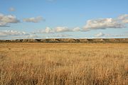
Caprock Escarpment south of Ralls


See also
 In Spanish: Condado de Crosby para niños
