
White River (Texas) facts for kids
Quick facts for kids White River |
|
|---|---|

Blanco Canyon carved by the White River
|
|
| Country | United States |
| State | Texas |
| Physical characteristics | |
| Main source | Callahan/Runningwater Draw Floyd County, Texas 973 m (3,192 ft) 33°58′44″N 101°29′28″W / 33.97889°N 101.49111°W |
| River mouth | Salt Fork, Brazos River Kent County, Texas 636 m (2,087 ft) 33°14′28″N 100°56′10″W / 33.24111°N 100.93611°W |
| Length | 100 km (62 mi) |
| Basin features | |
| Basin size | 4,377 km2 (1,690 sq mi) |
The White River is a stream in the South Plains of Texas that doesn't always flow, especially during dry times. It's a branch of the larger Brazos River. It starts about 8 miles (13 km) west of Floydada in Floyd County, where two smaller streams, Callahan and Runningwater Draws, join together.
From there, the White River flows southeast for about 62 miles (100 km). It ends when it joins the Salt Fork of the Brazos River in Kent County. Other small streams that flow into the White River include Pete, Crawfish, and Davidson Creeks. The river drains an area of about 1,690 square miles (4,377 km²).
The White River helped create Blanco Canyon by carving its way through the land as it flows down from the Llano Estacado. Long ago, on October 9, 1871, a battle called the Battle of Blanco Canyon took place along the river. Colonel Ranald S. Mackenzie fought against Quanah Parker there.
In 1963, a dam was built on the river in Crosby County. This created the White River Reservoir, which provides water for towns like Post, Spur, Crosbyton, and Ralls.
Spanish hunters and traders knew about this river long before settlers from other parts of Europe arrived. They called it Blanco, which means "white" in Spanish. This name is also used for the canyon. Over time, the name became "White River" in English. It was also sometimes called the "Blanco Fork of Brazos River" or the "White Fork of Brazos River".
People who live near the river say that its water level has been dropping. This is because of too much pumping of water from underground, which is emptying the Ogallala Aquifer. One person said, "you could catch fish in it until 1955.... Today, the water is 80 feet down."
Contents
Silver Falls: A Changing Landscape
Where U.S. Route 82 crosses the White River, there's a rest area with hiking trails. The main attraction here used to be Silver Falls. This was a beautiful spot where the White River, fed by natural springs, would flow over sandstone ledges.
Why Silver Falls is Often Dry Now
The springs that fed the White River at Silver Falls got their water from the Ogallala Aquifer. This underground water source has been used a lot by farms on the Llano Estacado. Because so much water is being pumped out, the water level in the aquifer is dropping.
Over the last ten years, the water table (the top of the underground water) has gone down about 0.8 feet (0.24 meters) each year. From 1987 to 2007, it dropped a total of 18.6 feet (5.7 meters). Because of this, the springs that once flowed into the White River have either completely dried up or are now just tiny trickles. This means the White River no longer has a steady flow of water. Today, Silver Falls is usually dry unless there's a big thunderstorm that brings a lot of rain to the area.
-
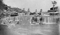
A spring-fed White River flowing across Silver Falls in 1891
-
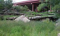
Due to agricultural pumping and resulting depletion of the Ogallala Aquifer, the White River no longer maintains a spring-fed base flow, and today, Silver Falls is often dry and overgrown by vegetation.


What is the River's Official Name?
The White River has been called many different names in the past. Some of these names include Freshwater Fork, Blanco Fork, or White Fork of the Brazos River, and Rio Blanco. In 1964, the United States Board on Geographic Names officially decided that the correct name for this stream is the White River.
See also
 In Spanish: Río Blanco (Texas) para niños
