Hood County, Texas facts for kids
Quick facts for kids
Hood County
|
|
|---|---|

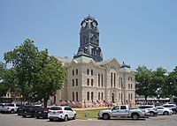
The Hood County Courthouse in Granbury
|
|

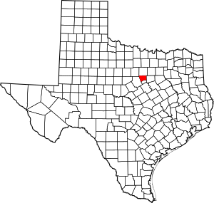
Location within the U.S. state of Texas
|
|
 Texas's location within the U.S. |
|
| Country | |
| State | |
| Founded | 1866 |
| Named for | John Bell Hood |
| Seat | Granbury |
| Largest city | Granbury |
| Area | |
| • Total | 437 sq mi (1,130 km2) |
| • Land | 421 sq mi (1,090 km2) |
| • Water | 16 sq mi (40 km2) 3.7% |
| Population
(2020)
|
|
| • Total | 61,598 |
| • Density | 140.96/sq mi (54.42/km2) |
| Time zone | UTC−6 (Central) |
| • Summer (DST) | UTC−5 (CDT) |
| Congressional district | 25th |
Hood County is a special area in the state of Texas, USA, called a county. In 2020, about 61,598 people lived here. The main town, or county seat, where the county government is located, is Granbury.
Hood County got its name from John Bell Hood. He was a very important general in the Confederate Army during the American Civil War. He also led a famous group of soldiers called Hood's Texas Brigade.
This county is close to the big cities of Dallas and Fort Worth. This means it's influenced by the larger Dallas–Fort Worth metroplex area.
Contents
History of Hood County
Hood County was officially created in 1866. It was formed using parts of two other counties: Johnson County and Erath County. As mentioned, it was named after General John Bell Hood. He was a well-known general in the Confederate Army.
Geography and Nature
According to the U.S. Census Bureau, Hood County covers a total area of about 437 square miles. Most of this area, about 421 square miles, is land. The remaining 16 square miles, which is about 3.7% of the county, is covered by water.
Main Roads in Hood County
These are the most important highways that run through Hood County:
Neighboring Counties
Hood County shares its borders with several other counties:
- Parker County to the north
- Johnson County to the east
- Somervell County to the south
- Erath County to the west
- Palo Pinto County to the northwest
Population and People
| Historical population | |||
|---|---|---|---|
| Census | Pop. | %± | |
| 1870 | 2,585 | — | |
| 1880 | 6,125 | 136.9% | |
| 1890 | 7,614 | 24.3% | |
| 1900 | 9,146 | 20.1% | |
| 1910 | 10,008 | 9.4% | |
| 1920 | 8,759 | −12.5% | |
| 1930 | 6,779 | −22.6% | |
| 1940 | 6,674 | −1.5% | |
| 1950 | 5,287 | −20.8% | |
| 1960 | 5,443 | 3.0% | |
| 1970 | 6,398 | 17.5% | |
| 1980 | 17,714 | 176.9% | |
| 1990 | 28,981 | 63.6% | |
| 2000 | 41,100 | 41.8% | |
| 2010 | 51,182 | 24.5% | |
| 2020 | 61,598 | 20.4% | |
| U.S. Decennial Census 1850–2010 2010 2020 |
|||
Hood County has grown a lot over the years. In 2000, there were 41,100 people living here. By 2020, the population had grown to 61,598. This shows that more and more people are choosing to live in Hood County.
Most people in Hood County are White. However, the county is also home to people from many different backgrounds. This includes people who are Black or African American, Native American, Asian, and those of Hispanic or Latino heritage. The number of people from diverse backgrounds has been increasing.
In 2000, about 28.8% of households had children under 18 living with them. The average household had about 2.5 people. The average age of people in the county was 42 years old.
Local Media
Hood County is part of the big TV market that includes Dallas and Fort Worth. This means people in Hood County can watch many TV channels from these cities. Some of these channels are KDFW-TV, KXAS-TV, and WFAA-TV.
For local news, Hood County has two newspapers. One is the Hood County Free Press, which is an online newspaper. The other is the Hood County News (https://hcnews.com), which comes out twice a week.
Schools and Education
Several school districts serve the students in Hood County. A school district is a local organization that runs public schools.
Here are the school districts that serve Hood County:
- Bluff Dale ISD (mostly in Erath County)
- Godley ISD (mostly in Johnson County)
- Granbury ISD (also in parts of Johnson and Parker Counties)
- Lipan ISD (also in parts of Erath, Palo Pinto, and Parker Counties)
- Tolar ISD
Communities in Hood County
Hood County has several towns and communities where people live.
Cities
These are the official cities in Hood County:
- Cresson (partly in Parker and Johnson counties)
- DeCordova
- Granbury (This is the county seat)
- Lipan
- Stockton Bend
- Tolar
Census-Designated Places
These are areas that are like towns but are not officially incorporated as cities:
- Canyon Creek
- Oak Trail Shores
- Pecan Plantation
Unincorporated Communities
These are smaller communities that are not part of any city or census-designated place:
See also
 In Spanish: Condado de Hood para niños
 | John T. Biggers |
 | Thomas Blackshear |
 | Mark Bradford |
 | Beverly Buchanan |


