Johnson County, Texas facts for kids
Quick facts for kids
Johnson County
|
|
|---|---|

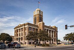
The Johnson County Courthouse
|
|

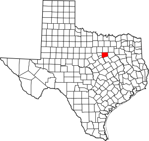
Location within the U.S. state of Texas
|
|
 Texas's location within the U.S. |
|
| Country | |
| State | |
| Founded | 1854 |
| Seat | Cleburne |
| Largest city | Burleson |
| Area | |
| • Total | 734 sq mi (1,900 km2) |
| • Land | 725 sq mi (1,880 km2) |
| • Water | 9.8 sq mi (25 km2) 1.3% |
| Population
(2020)
|
|
| • Total | 179,927 |
| • Estimate
(2023)
|
202,906 |
| • Density | 245.13/sq mi (94.65/km2) |
| Time zone | UTC−6 (Central) |
| • Summer (DST) | UTC−5 (CDT) |
| Congressional districts | 6th, 25th |
Johnson County is a county in the state of Texas. In 2020, about 179,927 people lived there. The main city, or county seat, is Cleburne.
Johnson County is named after Colonel Middleton Tate Johnson Sr. He was a Texas Ranger, a politician, and a soldier. He fought in the Mexican-American War and the American Civil War. Johnson County is part of the large Dallas–Fort Worth–Arlington metropolitan area.
Contents
History of Johnson County
The first person to settle in Johnson County was Henry Briden. He built a log cabin on the Nolan River in 1849. You can still see his old cabin today along State Highway 174 in Rio Vista, Texas.
The first county seat was Wardville. This town is now covered by the waters of Lake Pat Cleburne. In 1856, Buchanan became the new county seat.
In 1866, Johnson County was divided. The western part became Hood County. After this, Camp Henderson became the new county seat. It was renamed Cleburne to honor General Patrick Cleburne.
Geography of Johnson County
Johnson County covers a total area of about 734 square miles. Most of this area, about 725 square miles, is land. The remaining 9.8 square miles, or 1.3%, is covered by water.
Major Highways in Johnson County
Several important highways pass through Johnson County, making it easy to travel around.
 I-35W
I-35W Bus. I-35
 U.S. Highway 67
 U.S. Highway 287
 U.S. Highway 377
 State Highway 81
 State Highway 171
 State Highway 174
Counties Near Johnson County
Johnson County shares borders with several other counties:
- Tarrant County (to the north)
- Ellis County (to the east)
- Hill County (to the south)
- Bosque County (to the southwest)
- Somervell County (to the southwest)
- Hood County (to the west)
- Parker County (to the northwest)
Communities in Johnson County
Johnson County is home to many cities, towns, and smaller communities. Some of these places are located in more than one county.
Cities in Multiple Counties
- Burleson (also partly in Tarrant County)
- Cresson (also partly in Hood and Parker counties)
- Crowley (mostly in Tarrant County)
- Fort Worth (mostly in Tarrant County, with small parts in other counties, including Johnson)
- Mansfield (mostly in Tarrant County and partly in Ellis County)
- Venus (also partly in Ellis County)
Cities Only in Johnson County
Towns in Johnson County
Other Communities
- The Homesteads, Texas (a census-designated place)
- Beulah (unincorporated)
- Bono (unincorporated)
- Egan (unincorporated)
- Lillian (unincorporated)
- Parker (unincorporated)
- Sand Flat (unincorporated)
Population of Johnson County
| Historical population | |||
|---|---|---|---|
| Census | Pop. | %± | |
| 1860 | 4,305 | — | |
| 1870 | 4,923 | 14.4% | |
| 1880 | 17,911 | 263.8% | |
| 1890 | 22,313 | 24.6% | |
| 1900 | 33,819 | 51.6% | |
| 1910 | 34,460 | 1.9% | |
| 1920 | 37,286 | 8.2% | |
| 1930 | 33,317 | −10.6% | |
| 1940 | 30,384 | −8.8% | |
| 1950 | 31,390 | 3.3% | |
| 1960 | 34,720 | 10.6% | |
| 1970 | 45,769 | 31.8% | |
| 1980 | 67,649 | 47.8% | |
| 1990 | 97,165 | 43.6% | |
| 2000 | 126,811 | 30.5% | |
| 2010 | 150,934 | 19.0% | |
| 2020 | 179,927 | 19.2% | |
| 2023 (est.) | 202,906 | 34.4% | |
| U.S. Decennial Census 1850–2010 2020 |
|||
The population of Johnson County has grown a lot over the years. In 2020, there were 179,927 people living here. By 2023, the population was estimated to be even larger, around 202,906 people.
The county is made up of people from many different backgrounds. In 2023, about 25.9% of the population was Hispanic or Latino. About 64.4% were non-Hispanic White, and 5.8% were non-Hispanic Black. There were also smaller groups of non-Hispanic Asian, Native American, Pacific Islander, and people of two or more races.
Education in Johnson County
Johnson County has many school districts that serve its students.
- Alvarado Independent School District
- Burleson Independent School District
- Cleburne Independent School District
- Crowley Independent School District
- Godley Independent School District
- Granbury Independent School District
- Grandview Independent School District
- Joshua Independent School District
- Keene Independent School District
- Mansfield Independent School District
- Rio Vista Independent School District
- Venus Independent School District
For higher education, Hill College has a campus in Cleburne. It has been there since 1971. Johnson County is part of the area that Hill College serves.
Southwestern Adventist University is a private liberal arts university in Keene. It is the only four-year college in Johnson County. This university is connected to the Seventh-day Adventist Church and has been around since 1893.
Media in Johnson County
Johnson County is part of the Dallas/Fort Worth television market. This means people in the county can watch many TV channels from that area. Some local news channels include KDFW-TV, KXAS-TV, WFAA-TV, and KTVT-TV.
The local radio station is KCLE. It plays country music and also shares local news. For written news, people in Johnson County can read newspapers like the Cleburne Times-Review, the Burleson Star, and the Joshua Star.
See also
 In Spanish: Condado de Johnson (Texas) para niños
 | Lonnie Johnson |
 | Granville Woods |
 | Lewis Howard Latimer |
 | James West |

