
Parmer County, Texas facts for kids
Quick facts for kids
Parmer County
|
|
|---|---|

The Parmer County Courthouse in Farwell
|
|

Location within the U.S. state of Texas
|
|
 Texas's location within the U.S. |
|
| Country | |
| State | |
| Founded | 1907 |
| Named for | Martin Parmer |
| Seat | Farwell |
| Largest city | Friona |
| Area | |
| • Total | 885 sq mi (2,290 km2) |
| • Land | 881 sq mi (2,280 km2) |
| • Water | 4.4 sq mi (11 km2) 0.5% |
| Population
(2020)
|
|
| • Total | 9,869 |
| • Density | 11/sq mi (4/km2) |
| Time zone | UTC−6 (Central) |
| • Summer (DST) | UTC−5 (CDT) |
| Congressional district | 19th |
Parmer County is a special area in the state of Texas, located in the southwestern part of the Texas Panhandle. It sits on a high, flat area called the Llano Estacado. A "county" is like a smaller division of a state, similar to a district.
As of 2020, about 9,869 people live here. The main town, or "county seat," where the local government offices are, is Farwell. Parmer County was officially created in 1876 and started its government in 1907. It's named after Martin Parmer, who was an important person who signed the Texas Declaration of Independence.
For a long time, Parmer County was a "dry county," meaning you couldn't buy or sell alcohol there. But now, it's a "wet county," so alcohol sales are allowed.
Contents
Geography
Parmer County covers a total area of about 885 square miles. Most of this area, about 881 square miles, is land. The rest, about 4.4 square miles, is covered by water.
Main Roads
Here are some of the important highways that go through Parmer County:
 U.S. Highway 60
 U.S. Highway 70
 U.S. Highway 84
 State Highway 86
 State Highway 214
Neighboring Counties
Parmer County shares borders with these other counties:
- Deaf Smith County (to the north)
- Castro County (to the east)
- Lamb County (to the southeast)
- Bailey County (to the south)
- Curry County, New Mexico (to the west, in a different time zone)
Population Information
| Historical population | |||
|---|---|---|---|
| Census | Pop. | %± | |
| 1890 | 7 | — | |
| 1900 | 34 | 385.7% | |
| 1910 | 1,555 | 4,473.5% | |
| 1920 | 1,699 | 9.3% | |
| 1930 | 5,869 | 245.4% | |
| 1940 | 5,890 | 0.4% | |
| 1950 | 5,787 | −1.7% | |
| 1960 | 9,583 | 65.6% | |
| 1970 | 10,509 | 9.7% | |
| 1980 | 11,038 | 5.0% | |
| 1990 | 9,863 | −10.6% | |
| 2000 | 10,016 | 1.6% | |
| 2010 | 10,269 | 2.5% | |
| 2020 | 9,869 | −3.9% | |
| U.S. Decennial Census 1850–2010 2010 2020 |
|||
In 2000, there were 10,016 people living in Parmer County. About 66% of the people were White, and about 1% were Black or African American. Around 49% of the population identified as Hispanic or Latino.
The average family size was about 3 people. Many households had children under 18 living with them. The median age of people in the county was 32 years old. This means half the people were younger than 32, and half were older.
Towns and Communities
Here are the main towns and communities in Parmer County:
Cities
Other Communities
- Lazbuddie (This is a smaller community that is not officially a city)
Education
Students in Parmer County attend schools in several different school districts:
- Bovina Independent School District
- Farwell Independent School District
- Friona Independent School District
- Hereford Independent School District
- Lazbuddie Independent School District
After high school, students in the county can get services from Amarillo College, which is a community college.
Images for kids
-
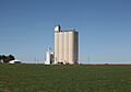
A grain elevator in the northwestern part of Parmer County.
-
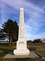
A monument in Farwell that remembers the Ozark Trail.
-
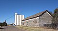
An old building and a grain elevator in Farwell.


See also
 In Spanish: Condado de Parmer para niños
