Curry County, New Mexico facts for kids
Quick facts for kids
Curry County
|
||
|---|---|---|
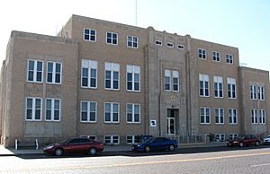
Curry County Courthouse in Clovis
|
||
|
||
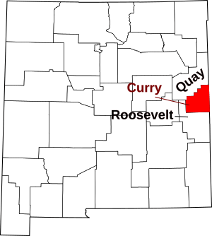
Location within the U.S. state of New Mexico
|
||
 New Mexico's location within the U.S. |
||
| Country | ||
| State | ||
| Founded | February 25, 1909 | |
| Named for | George Curry | |
| Seat | Clovis | |
| Largest city | Clovis | |
| Area | ||
| • Total | 1,408 sq mi (3,650 km2) | |
| • Land | 1,405 sq mi (3,640 km2) | |
| • Water | 3.2 sq mi (8 km2) 0.2%% | |
| Population
(2020)
|
||
| • Total | 48,430 | |
| • Density | 34.5/sq mi (13.3/km2) | |
| Time zone | UTC−7 (Mountain) | |
| • Summer (DST) | UTC−6 (MDT) | |
| Congressional district | 3rd | |
Curry County is a county located in the state of New Mexico. A county is like a smaller region within a state. As of the 2020 census, about 48,430 people lived here. Its main town, or county seat, is Clovis.
The county was named after George Curry. He was the governor of the New Mexico Territory from 1907 to 1910. A territory is an area that belongs to the United States but is not yet a state. Curry County is in the far eastern part of New Mexico. It is right next to Texas.
Contents
About Curry County
Where is Curry County?
Curry County is in the eastern part of New Mexico. It shares a border with Texas. The U.S. Census Bureau says the county covers about 1,408 square miles. Most of this area, about 1,405 square miles, is land. Only a small part, about 3.2 square miles, is water. This makes Curry County the fourth-smallest county in New Mexico by size.
Curry County is next to these other counties:
- Quay County to the northwest
- Roosevelt County to the south
- Bailey County, Texas to the southeast
- Parmer County, Texas to the east
- Deaf Smith County, Texas to the northeast
Who Lives Here?
The number of people living in Curry County has changed over the years. Here is how the population has grown:
| Historical population | |||
|---|---|---|---|
| Census | Pop. | %± | |
| 1910 | 11,443 | — | |
| 1920 | 11,236 | −1.8% | |
| 1930 | 15,809 | 40.7% | |
| 1940 | 18,159 | 14.9% | |
| 1950 | 23,351 | 28.6% | |
| 1960 | 32,691 | 40.0% | |
| 1970 | 39,517 | 20.9% | |
| 1980 | 42,019 | 6.3% | |
| 1990 | 42,207 | 0.4% | |
| 2000 | 45,044 | 6.7% | |
| 2010 | 48,376 | 7.4% | |
| 2020 | 48,430 | 0.1% | |
| U.S. Decennial Census 1790-1960 1900-1990 1990-2000 2010 |
|||
In 2010, there were 48,376 people living in Curry County. About 69.7% of the people were white. About 6.3% were African American. People of Hispanic or Latino background made up 39.5% of the population. The average age in the county was about 31.5 years old.
Towns and Villages
Curry County has several towns and communities.
Cities
Villages
Census-designated place
- Cannon AFB (This is a special area for the Air Force Base)
Unincorporated communities
These are smaller places that are not officially cities or villages:
Learning in Curry County
Students in Curry County attend schools in these districts:
- Clovis Municipal Schools
- Grady Municipal Schools
- Melrose Public Schools
- Texico Municipal Schools
See also
 In Spanish: Condado de Curry (Nuevo México) para niños
 | Selma Burke |
 | Pauline Powell Burns |
 | Frederick J. Brown |
 | Robert Blackburn |


