
Denton County, Texas facts for kids
Quick facts for kids
Denton County
|
||
|---|---|---|
|
County
|
||

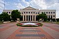
The Denton County Courts Building, built 1998
|
||
|
||

Location within the U.S. state of Texas
|
||
 Texas's location within the U.S. |
||
| Country | ||
| State | ||
| Founded | April 11, 1846 | |
| Named for | John B. Denton | |
| Seat | Denton | |
| Largest city | Denton | |
| Area | ||
| • Total | 953 sq mi (2,470 km2) | |
| • Land | 878 sq mi (2,270 km2) | |
| • Water | 75 sq mi (190 km2) 7.8% | |
| Population
(2020)
|
||
| • Total | 906,422 | |
| • Estimate
(2023)
|
1,006,492 |
|
| • Density | 951.1/sq mi (367.23/km2) | |
| Time zone | UTC−6 (Central) | |
| • Summer (DST) | UTC−5 (CDT) | |
| Congressional districts | 4th, 13th, 26th, 32nd | |

Denton County is a county in the U.S. state of Texas. It's located in the northern part of the state. In 2020, about 906,422 people lived there, making it the seventh-biggest county in Texas by population. The main city and county seat is Denton. The county was named after John B. Denton and was created in 1846. Denton County is part of a large area called the Dallas–Fort Worth metroplex. It has been one of the fastest-growing counties in the United States.
Contents
History of Denton County
Before settlers arrived, different Native American groups, like the Kichai and Lenape, sometimes lived in the area. In the early 1840s, people from the Peters Colony started to settle here. The area was part of Fannin County until Texas joined the United States.
On April 11, 1846, the First Texas Legislature officially created Denton County. It was named after John B. Denton, who died in 1841 during a conflict with a Native American village. At first, the county seat was a place called Pinckneyville. Later, it moved to Alton, where the Old Alton Bridge is today. Finally, the county seat was moved to Denton.
By 1860, the county's population grew to 5,031 people. In 1861, residents voted to leave the Union during the time leading up to the American Civil War. The vote was very close. In the early 1880s, the Missouri–Kansas–Texas Railroad reached Lewisville, a city in the southern part of the county. The Denton County Courthouse-on-the-Square was built in 1896. Today, it holds government offices and a museum.
Geography and Nature
| Weather chart for Denton, Texas | |||||||||||||||||||||||||||||||||||||||||||||||
|---|---|---|---|---|---|---|---|---|---|---|---|---|---|---|---|---|---|---|---|---|---|---|---|---|---|---|---|---|---|---|---|---|---|---|---|---|---|---|---|---|---|---|---|---|---|---|---|
| J | F | M | A | M | J | J | A | S | O | N | D | ||||||||||||||||||||||||||||||||||||
|
2.1
56
33
|
2.9
60
36
|
3.2
68
44
|
3.3
76
52
|
5.1
83
63
|
3.6
91
70
|
2.4
95
74
|
2.1
96
73
|
3.1
88
66
|
5
78
55
|
2.9
66
44
|
2.6
57
35
|
||||||||||||||||||||||||||||||||||||
| temperatures in °F precipitation totals in inches |
|||||||||||||||||||||||||||||||||||||||||||||||
|
Metric conversion
|
|||||||||||||||||||||||||||||||||||||||||||||||
Denton County covers about 953 square miles. Most of this is land (878 square miles), and 75 square miles (about 7.8%) are covered by water. The county is in northern Texas, about 35 miles south of the border with Oklahoma. Two branches of the Trinity River flow through it.
The biggest lake in Denton County is Lewisville Lake. It was created in 1954 when two smaller lakes, the Garza–Little Elm Reservoir and Lake Dallas, were joined together. The county is on the edge of the eastern Cross Timbers area and also includes parts of the Grand Prairie, which is part of the Texas blackland prairies.
Some parts of Denton County are on top of the Barnett Shale. This is a rock formation that contains a lot of natural gas. Between 1995 and 2007, the number of natural gas wells in the county grew from 156 to 1,820.
Lakes in Denton County
Neighboring Counties
Denton County shares borders with these other counties:
- Cooke County (north)
- Grayson County (northeast)
- Collin County (east)
- Dallas County (southeast)
- Tarrant County (south)
- Wise County (west)
Cities and Towns
Denton County has many cities and towns. Some of them are located entirely within Denton County, while others spread across multiple counties.
Cities in Multiple Counties
These cities are partly in Denton County and partly in other counties:
- Carrollton (also in Dallas and Collin Counties)
- Celina (mostly in Collin County)
- Coppell (mostly in Dallas County)
- Dallas (mostly in Dallas County)
- Fort Worth (mostly in Tarrant County)
- Frisco (mostly in Collin County)
- Grapevine (mostly in Tarrant County)
- Haslet (mostly in Tarrant County)
- Lewisville (small part in Dallas County)
- Plano (mostly in Collin County)
- Southlake (mostly in Tarrant County)
Cities Only in Denton County
Towns in Multiple Counties
These towns are partly in Denton County and partly in other counties:
- Flower Mound (small part in Tarrant County)
- Hebron (small part in Collin County)
- Prosper (mostly in Collin County)
- Trophy Club (small part in Tarrant County)
- Westlake (mostly in Tarrant County)
Towns Only in Denton County
Other Communities
- Census-designated places: These are areas that are like towns but are not officially incorporated as cities or towns.
- Unincorporated communities: These are small communities that are not part of any city or town.
- Ghost towns: These are places where people used to live, but now they are mostly empty.
- Alton
- Camey Spur
- Cooper Creek
- Drop
- Elizabethtown
- Green Valley
- Marshall Creek
- Mayhill
- Mingo
- Mustang
- Parvin
- Plainview
- Stony
Population and People
Denton County has grown a lot over the years. In 1850, only 641 people lived there. By 2020, the population had reached 906,422. This makes it one of the fastest-growing counties in the U.S.
| Race / Ethnicity (NH = Non-Hispanic) | Pop 1990 | Pop 2000 | Pop 2010 | Pop 2020 | % 1990 | % 2000 | % 2010 | % 2020 |
|---|---|---|---|---|---|---|---|---|
| White alone (NH) | 232,885 | 328,849 | 426,887 | 485,646 | 85.14% | 75.95% | 64.42% | 53.58% |
| Black or African American alone (NH) | 13,314 | 24,980 | 54,034 | 95,386 | 4.87% | 5.77% | 8.15% | 10.52% |
| Native American or Alaska Native alone (NH) | 1,326 | 2,093 | 3,143 | 3,582 | 0.48% | 0.48% | 0.47% | 0.40% |
| Asian alone (NH) | 6,753 | 17,327 | 43,091 | 92,751 | 2.47% | 4.00% | 6.50% | 10.23% |
| Pacific Islander alone (NH) | N/A | 186 | 411 | 650 | N/A | 0.04% | 0.06% | 0.07% |
| Other race alone (NH) | 234 | 559 | 1,176 | 3,909 | 0.09% | 0.13% | 0.18% | 0.43% |
| Mixed race or Multiracial (NH) | N/A | 6,363 | 13,036 | 41,720 | N/2 | 1.47% | 1.97% | 4.60% |
| Hispanic or Latino (any race) | 19,013 | 52,619 | 120,836 | 182,778 | 6.95% | 12.15% | 18.24% | 20.16% |
| Total | 273,525 | 432,976 | 662,614 | 906,422 | 100.00% | 100.00% | 100.00% | 100.00% |
In 2010, the population of Denton County was 662,614 people. The county had about 754 people per square mile. By 2020, the population grew to 906,422. This shows that many people are moving to communities outside of big cities like Dallas and Fort Worth.
In 2010, about 75% of the people in the county were White, 8.4% were African American, 0.7% were Native American, and 6.6% were Asian. About 18.2% of the population was Hispanic or Latino. By 2020, the population became even more diverse.
Education in Denton County
Denton County has many schools and colleges.
K-12 Schools
Several school districts serve the students in Denton County. Some districts are entirely within the county, while others cover parts of Denton County and other counties.
School Districts Entirely in Denton County
- Argyle Independent School District
- Aubrey Independent School District
- Denton Independent School District
- Lake Dallas Independent School District
- Lewisville Independent School District
- Little Elm Independent School District
- Ponder Independent School District
- Sanger Independent School District
School Districts Partly in Denton County
- Carrollton-Farmers Branch Independent School District
- Celina Independent School District
- Era Independent School District
- Frisco Independent School District
- Krum Independent School District
- Northwest Independent School District
- Pilot Point Independent School District
- Prosper Independent School District
- Slidell Independent School District
Private Schools
Denton County also has several private schools:
- Denton Calvary Academy
- Coram Deo Academy
- Lakeland Christian Academy
- Liberty Christian School
- Selwyn College Preparatory School
Colleges and Universities
.jpg)
Most of Denton County is served by North Central Texas College for community college classes. However, some areas are assigned to Collin College or Dallas College.
Denton County is also home to two four-year universities:
- University of North Texas (UNT)
- Texas Woman's University
Transportation
The Denton County Transportation Authority (DCTA) helps people get around the county. They offer bus services and a special on-demand service called GoZone in cities like Denton, Lewisville, and Highland Village. For areas outside these cities, SPAN Transit provides transportation.
The DCTA also runs the A-train. This is a commuter train that goes from Denton to Carrollton. In Carrollton, passengers can switch to the Green Line train, which is run by Dallas Area Rapid Transit (DART). From there, you can connect to other DART train lines in downtown Dallas.
Denton County has two airports: the Denton Municipal Airport and the Northwest Regional Airport in Roanoke. The large Dallas/Fort Worth International Airport is just a few miles south of the county.
Major Highways
Many important highways run through Denton County, connecting it to other parts of Texas:
 I-35
I-35 I-35E
I-35E I-35W
I-35W Bus. I-35
 US 77
US 77 US 377
 US 380
 SH 114
 SH 121 / Sam Rayburn Tollway
 SH 170
 Loop 288
 Pres. George Bush Turnpike
Notable People from Denton County
Many famous people have connections to Denton County, including:
- Dick Armey, a former U.S. House Majority Leader.
- Joan Blondell, a film and TV actress who attended UNT.
- Pat Boone, a pop singer who briefly attended UNT.
- Bowling for Soup, an American rock band based in Denton.
- Terry Bradshaw, a famous former football quarterback.
- Mason Cox, a professional Australian rules footballer.
- Phyllis George, a former Miss America and sportscaster.
- Joe Greene, a Hall of Fame football player.
- Jim Hightower, a former Texas Agriculture Commissioner.
- Norah Jones, a Grammy-winning jazz musician who studied at UNT.
- Meat Loaf, a singer and actor who attended UNT.
- Bill Moyers, a former White House press secretary who attended UNT.
- Anne Rice, a famous author who attended TWU and UNT.
- Ann Sheridan, a popular actress and singer born in Denton.
- Sly Stone, a musician and frontman of Sly and the Family Stone.
- Rex Tillerson, a former CEO of ExxonMobil and U.S. Secretary of State.
- Von Erich family, a famous family of professional wrestlers.
Images for kids
-
The Denton County Courts Building, built in 1998.
-

The official seal of Denton County, Texas.
See also
 In Spanish: Condado de Denton para niños
