Sanger, Texas facts for kids
Quick facts for kids
Sanger, Texas
|
|
|---|---|
 |
|

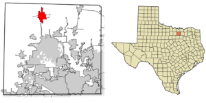
Location of Sanger in Denton County, Texas
|
|
| Country | United States |
| State | Texas |
| County | Denton |
| Government | |
| • Type | Council-manager |
| Area | |
| • Total | 11.81 sq mi (30.59 km2) |
| • Land | 11.76 sq mi (30.46 km2) |
| • Water | 0.05 sq mi (0.14 km2) |
| Elevation | 673 ft (205 m) |
| Population
(2020)
|
|
| • Total | 8,839 |
| • Density | 742.58/sq mi (286.71/km2) |
| Time zone | UTC-6 (Central (CST)) |
| • Summer (DST) | UTC-5 (CDT) |
| ZIP code |
76266
|
| Area code(s) | 940 |
| FIPS code | 48-65408 |
| GNIS feature ID | 2411812 |
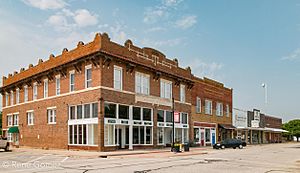
Sanger is a city located in Denton County, Texas, in the United States. In 2020, about 8,839 people lived there.
Contents
Where is Sanger Located?
Sanger is found at 33°21′47″N 97°10′34″W / 33.36306°N 97.17611°W. The city covers a total area of about 28.3 square kilometers (10.9 square miles). Only a small part of this area, about 0.1 square kilometers (0.04 square miles), is covered by water.
Sanger's Climate
The weather in Sanger is usually hot and humid in the summer. Winters are generally mild to cool. This type of weather is known as a humid subtropical climate.
Who Lives in Sanger?
The number of people living in Sanger has grown a lot over the years.
| Historical population | |||
|---|---|---|---|
| Census | Pop. | %± | |
| 1920 | 1,204 | — | |
| 1930 | 1,119 | −7.1% | |
| 1940 | 1,000 | −10.6% | |
| 1950 | 1,170 | 17.0% | |
| 1960 | 1,190 | 1.7% | |
| 1970 | 1,603 | 34.7% | |
| 1980 | 2,574 | 60.6% | |
| 1990 | 3,508 | 36.3% | |
| 2000 | 4,534 | 29.2% | |
| 2010 | 6,916 | 52.5% | |
| 2020 | 8,839 | 27.8% | |
| 2023 (est.) | 9,831 | 42.1% | |
| U.S. Decennial Census | |||
For example, in 1980, there were 2,574 people. By 2010, the population had grown to 6,916. In 2020, the city had 8,839 residents. There were 2,842 households and 2,055 families living in Sanger at that time.
Diversity in Sanger
Sanger is home to people from many different backgrounds. Here's a look at the racial makeup of the city in 2020:
| Race | Number of People | Percentage |
|---|---|---|
| White (Not Hispanic) | 6,029 | 68.21% |
| Black or African American (Not Hispanic) | 321 | 3.63% |
| Native American or Alaska Native (Not Hispanic) | 49 | 0.55% |
| Asian (Not Hispanic) | 80 | 0.91% |
| Pacific Islander (Not Hispanic) | 4 | 0.05% |
| Some other race (Not Hispanic) | 54 | 0.61% |
| Mixed/multiracial (Not Hispanic) | 453 | 5.13% |
| Hispanic or Latino | 1,849 | 20.92% |
| Total | 8,839 |
Note: The US Census counts Hispanic/Latino people as an ethnic group. They can be of any race.
Sanger's Economy
In 2022, Sanger did not have its own grocery store. Before that, there was one, but it closed. The Sanger Independent School District then started a special charity grocery store just for its students.
Learning in Sanger
Public schools in Sanger are managed by the Sanger Independent School District (Sanger ISD). Dr. Sandra McCoy-Jackson is the superintendent.
There are eight schools in Sanger, Texas:
- Sanger High School
- Linda Tutt High School
- Sanger Middle School
- Sanger 6th Grade Campus
- Clear Creek Intermediate School
- Butterfield Elementary School
- Chisholm Trail Elementary
- Tenderfoot Child Development Center
Sanger ISD has new facilities, including a high school and an elementary school. The city and the school district work closely together. Sanger ISD has also started a program to use more technology in teaching. Students in grades 8–12 can borrow technology devices, and all grades have more access to technology.
In 2022, about 20% of the adults in Sanger had a bachelor's degree from a college or university.
Famous People from Sanger
Some well-known people have connections to Sanger:
- Dane Evans – An American professional Canadian football quarterback.
- James F. Hollingsworth – A United States Army lieutenant general who was born in Sanger.
- Ty O'Neal – An American actor who lives in Sanger now.
- Jay Ramsey – An American singer, songwriter, and musician who grew up in Sanger.
- Lynn Stucky – A veterinarian and Republican member of the Texas House of Representatives.
- Larry Tidwell – An American college basketball coach who was born in Sanger.
- Marijohn Wilkin – An American songwriter famous in country music.
See also
 In Spanish: Sanger (Texas) para niños
 | May Edward Chinn |
 | Rebecca Cole |
 | Alexa Canady |
 | Dorothy Lavinia Brown |

