
Dallas County, Texas facts for kids
Quick facts for kids
Dallas County
|
||
|---|---|---|
|
From top, left to right: Dallas panorama, Dallas Hall in University Park, former Dallas County Courthouse with the Texas flag in 2017, Las Colinas in Irving
|
||
|
||

Location within the U.S. state of Texas
|
||
 Texas's location within the U.S. |
||
| Country | ||
| State | ||
| Founded | March 30, 1846 | |
| Named for | George M. Dallas | |
| Seat | Dallas | |
| Largest city | Dallas | |
| Area | ||
| • Total | 908.54 sq mi (2,353.1 km2) | |
| • Land | 873.06 sq mi (2,261.2 km2) | |
| • Water | 35.48 sq mi (91.9 km2) | |
| Population
(2020)
|
||
| • Total | 2,613,539 | |
| • Estimate
(2023)
|
2,606,358 |
|
| • Density | 2,876.636/sq mi (1,110.675/km2) | |
| Time zone | UTC−6 (Central) | |
| • Summer (DST) | UTC−5 (CDT) | |
| Congressional districts | 5th, 6th, 24th, 30th, 32nd, 33rd | |


Dallas County is a large and important county in the state of Texas. It is the second most populated county in Texas. In 2020, over 2.6 million people lived here. This makes it one of the most populated counties in the entire United States.
Dallas County is part of a big area called the Dallas-Arlington-Fort Worth metropolitan area. People often call this whole region the Dallas–Fort Worth metroplex. Many cities in Dallas County have grown so much that their borders blend together. They also blend with cities in nearby counties.
The main city and county seat is Dallas. Dallas is the third-largest city in Texas and the ninth-largest city in the U.S. Dallas County was started in 1846. It might have been named after George Mifflin Dallas. He was the 11th Vice President of the United States.
Contents
Where is Dallas County?
_UTA.jpg)
Dallas County covers about 909 square miles. Most of this area, about 873 square miles, is land. The rest, about 36 square miles, is water. The county also has 21 nature preserves. These are special areas of land kept natural for everyone to enjoy.
Neighboring Counties
Dallas County shares its borders with several other counties:
- Denton County (to the northwest)
- Collin County (to the northeast)
- Rockwall County (to the east)
- Kaufman County (to the southeast)
- Ellis County (to the south)
- Tarrant County (to the west)
Towns and Cities
Dallas County is home to many different communities. Some cities are so large they spread into more than one county.
Cities in Multiple Counties
These cities are partly in Dallas County and partly in other counties:
- Carrollton (also in Denton and Collin counties)
- Cedar Hill (also in Ellis County)
- Combine (also in Kaufman County)
- Coppell (also in Denton County)
- Dallas (also in Collin, Denton, Kaufman, and Rockwall counties)
- Ferris (mostly in Ellis County)
- Garland (also in Collin and Rockwall counties)
- Glenn Heights (also in Ellis County)
- Grand Prairie (also in Tarrant and Ellis counties)
- Grapevine (mostly in Tarrant and also in Denton County)
- Lewisville (mostly in Denton County)
- Mesquite (also in Kaufman County)
- Ovilla (mostly in Ellis County)
- Richardson (also in Collin County)
- Rowlett (also in Rockwall County)
- Sachse (also in Collin County)
- Seagoville (also in Kaufman County)
- Wylie (mostly in Collin and also in Rockwall County)
Cities Only in Dallas County
These cities are fully within Dallas County:
Towns in Dallas County
Unincorporated Areas
These are areas that are not part of any city or town.
Census-designated places
- Bear Creek Ranch
Other communities
Historical Communities
Many smaller communities used to exist in Dallas County. Over time, some of these were absorbed by larger cities like Dallas. Others merged to form new towns.
- Alpha
- Buckingham
- Cedar Springs
- Duck Creek
- East Dallas
- Embree
- Fruitdale
- Hatterville
- Hord's Ridge
- Kleberg
- La Reunion
- Letot
- Liberty Grove
- Lisbon
- Little Egypt
- Long Creek
- Meaders
- New Hope
- Noel Junction
- Oak Cliff
- Penn Springs
- Pleasant Grove
- Preston Hollow
- Renner
- Rylie
- Scyene
- Trinity Mills
- Tripp
Population of Dallas County
| Historical population | |||
|---|---|---|---|
| Census | Pop. | %± | |
| 1850 | 2,743 | — | |
| 1860 | 8,665 | 215.9% | |
| 1870 | 13,814 | 59.4% | |
| 1880 | 33,488 | 142.4% | |
| 1890 | 67,042 | 100.2% | |
| 1900 | 82,726 | 23.4% | |
| 1910 | 135,748 | 64.1% | |
| 1920 | 210,551 | 55.1% | |
| 1930 | 325,691 | 54.7% | |
| 1940 | 398,564 | 22.4% | |
| 1950 | 614,799 | 54.3% | |
| 1960 | 951,527 | 54.8% | |
| 1970 | 1,327,321 | 39.5% | |
| 1980 | 1,556,390 | 17.3% | |
| 1990 | 1,852,810 | 19.0% | |
| 2000 | 2,218,899 | 19.8% | |
| 2010 | 2,368,139 | 6.7% | |
| 2020 | 2,611,481 | 10.3% | |
| 2023 (est.) | 2,606,358 | 10.1% | |
| U.S. Decennial Census 2010–2020 |
|||
Dallas County is a very diverse place. People from many different backgrounds live here. In 2020, the county's population was 2,613,539.
The population has grown a lot over the years. In 1850, there were only 2,743 people. By 1950, it was over 600,000. Today, it's more than 2.6 million!
In 2020, about 40% of the people in Dallas County were of Hispanic or Latino background. About 28% were non-Hispanic White, and 22% were Black or African American. There are also growing Asian and multiracial communities. This mix of cultures makes Dallas County a vibrant place.
The average age in Dallas County in 2010 was 31 years old. This means it's a relatively young county. Many families with children live here.
Images for kids
-
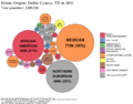
Ethnic origins in Dallas County, TX

See also
 In Spanish: Condado de Dallas (Texas) para niños
