Lancaster, Texas facts for kids
Quick facts for kids
Lancaster, Texas
|
|
|---|---|
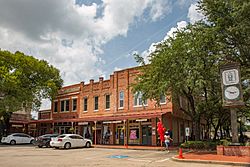
Lancaster's Historic Town Square
|
|
| Nickname(s):
The City of Trees
|
|
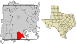
Location of Lancaster in Dallas County, Texas
|
|
| Country | |
| State | |
| County | |
| Government | |
| • Type | Council-Manager |
| Area | |
| • Total | 33.11 sq mi (85.77 km2) |
| • Land | 33.06 sq mi (85.63 km2) |
| • Water | 0.05 sq mi (0.14 km2) |
| Elevation | 522 ft (159 m) |
| Population
(2020)
|
|
| • Total | 41,275 |
| • Estimate
(2023)
|
40,215 |
| • Density | 1,186.50/sq mi (458.10/km2) |
| Time zone | UTC−6 (Central) |
| • Summer (DST) | UTC−5 (Central) |
| ZIP Codes |
75134, 75146
|
| Area code(s) | 214, 469, 945, 972 |
| FIPS code | 48-41212 |
| GNIS feature ID | 1339599 |
| Website | Lancaster-TX.com |
Lancaster is a city in Dallas County, Texas, United States. In 2020, its population was 41,275 people.
Lancaster was founded in 1852 as a frontier post, which was like an early settlement on the edge of new territory. It is one of the oldest communities in Dallas County. Today, Lancaster is a suburban city located in the Dallas–Fort Worth metroplex. It is about 15 miles (24 km) south of downtown Dallas.
Lancaster is part of the "Best Southwest" area. This area also includes the cities of Cedar Hill, DeSoto, and Duncanville.
Contents
History
How Lancaster Began
In 1841, the Republic of Texas government offered free land to companies that could bring new settlers to North Texas. William S. Peters and his partners helped about 600 families settle in what became known as Peters Colony between 1841 and 1844. Many early settlers came from Kentucky, Illinois, Missouri, and Tennessee.
The first group to settle in the Lancaster area arrived in January 1845. They formed a small community called Hardscrabble, made of log cabins.
A few miles north, another community called Pleasant Run was started in 1846. It grew to have a general store, a post office, a school, and a mill. However, Pleasant Run later declined, and Lancaster became the main community.
The Founding of Lancaster City
The founder of Lancaster was "A" Bledsoe, who was born in Lancaster, Kentucky, in 1801. He surveyed and planned the original town of Lancaster in 1852.
Bledsoe bought 430 acres of land and designed the town like his hometown in Kentucky. It had a town square with streets entering from the middle of each side. He started selling land lots in 1853, giving many to settlers from Pleasant Run. The official town plan was filed in 1857. A post office opened in Lancaster in 1860.
Growth and Challenges
During the American Civil War, a factory on West Main Street in Lancaster made replicas of .44 caliber Colt Dragoon guns. After the war, a drought made times tough for the economy. Things got better in the 1870s because the town was near busy cattle trails.
The first public well was dug in the town square in 1876. Fires damaged parts of the square in 1877, 1889, and 1918, but it was rebuilt each time. Local telephone service came to Lancaster in 1881. Lancaster officially became a city on May 5, 1886. The Lancaster Herald newspaper started printing a year later.
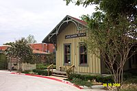
In December 1888, Lancaster got a train depot as a stop on the Dallas and Waco Railway. By 1891, it was part of the Missouri–Kansas–Texas Railroad (MKT) line. The Lancaster Tap Railroad, finished in 1890, connected Lancaster to another major rail line. The first official bank opened in 1889. By 1897, Lancaster had a public school, churches, and other organizations. From 1898 to 1901, Texas Christian University founder Randolph Clark started Randolph College in Lancaster.
Early 1900s
At the start of the 20th century, Lancaster had over 1,000 residents. It served many more people from nearby farms who came to work, shop, and go to school. The Texas Legislature created the Lancaster Independent School District in 1905. Over the next decade, voters approved plans to improve schools.
Electric lighting came to Lancaster in 1911. Farmers in the area grew many crops like wheat, cotton, and sweet potatoes. Businesses related to farming did well until the Dust Bowl and Great Depression caused the economy to slow down.
On February 27, 1934, Clyde Barrow, famous from Bonnie & Clyde, robbed the R.P. Henry and Sons Bank in Lancaster. He and Raymond Hamilton took over $4,000. In June 1936, a storm damaged many homes and the city's water tower. The economy started to improve in the early 1940s.
Becoming a Modern Suburb
Between 1900 and 1940, Lancaster's population grew slowly. By 1950, it had about 2,600 people. After that, the city grew much faster as it became a "bedroom community" for Dallas. This means many people lived in Lancaster but worked in Dallas. By 1960, the population had jumped to over 7,500.
In the 1970s, the town square was improved, and Cedar Valley College opened in 1977. Growth continued in the 1980s with new schools, shopping centers, and homes.
Recent Events
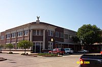
On April 25, 1994, a strong tornado hit Lancaster. It damaged or destroyed over 250 homes and every building on the town square. The White and Company Bank building, a local landmark, was badly damaged but rebuilt.
In 2005 and 2006, Lancaster was a finalist for the All-America City Award. In 2007, it was named a Tree City USA by the National Arbor Day Foundation.
Between 2000 and 2010, Lancaster's population grew by 40%, making it one of the fastest-growing cities in Dallas County. On April 3, 2012, another tornado struck the city, damaging 300 buildings. No deaths were reported from this tornado.
On June 23, 2019, Lancaster received the All-America City Award from the National Civic League. The city was recognized for its efforts to improve community health, including new parks and health programs.
Geography
Lancaster is in southern Dallas County, Texas. It is part of the Dallas–Fort Worth metroplex, which is the largest metropolitan area in Texas. The city covers about 30.35 square miles (78.6 km2). Most of this area is land, with a small amount of water.
Lancaster is located in the Blackland Prairie region. This area has flat or gently rolling land. Ten Mile Creek and its smaller streams flow through the city. Because the land was used for farming, much of the natural plant life has been cleared. However, areas near creeks still have trees like pecan, cedar elm, and various oak species.
Climate
Lancaster has a humid subtropical climate. This means it has hot, humid summers and mild to cool winters. July is usually the warmest month, and January is the coolest. May typically has the most rain.
| Climate data for Lancaster, Texas | |||||||||||||
|---|---|---|---|---|---|---|---|---|---|---|---|---|---|
| Month | Jan | Feb | Mar | Apr | May | Jun | Jul | Aug | Sep | Oct | Nov | Dec | Year |
| Mean daily maximum °F (°C) | 57 (14) |
61 (16) |
69 (21) |
77 (25) |
84 (29) |
92 (33) |
96 (36) |
96 (36) |
89 (32) |
79 (26) |
67 (19) |
58 (14) |
77 (25) |
| Mean daily minimum °F (°C) | 37 (3) |
41 (5) |
49 (9) |
56 (13) |
65 (18) |
73 (23) |
77 (25) |
77 (25) |
69 (21) |
58 (14) |
48 (9) |
39 (4) |
57 (14) |
| Average precipitation inches (mm) | 2.06 (52) |
2.70 (69) |
3.49 (89) |
3.07 (78) |
4.92 (125) |
4.11 (104) |
2.21 (56) |
1.87 (47) |
2.84 (72) |
4.79 (122) |
2.88 (73) |
2.74 (70) |
37.68 (957) |
| Source: The Weather Channel (extremes) | |||||||||||||
Demographics
| Historical population | |||
|---|---|---|---|
| Census | Pop. | %± | |
| 1880 | 497 | — | |
| 1890 | 741 | 49.1% | |
| 1900 | 1,045 | 41.0% | |
| 1910 | 1,115 | 6.7% | |
| 1920 | 1,190 | 6.7% | |
| 1930 | 1,133 | −4.8% | |
| 1940 | 1,151 | 1.6% | |
| 1950 | 2,632 | 128.7% | |
| 1960 | 7,501 | 185.0% | |
| 1970 | 10,522 | 40.3% | |
| 1980 | 14,807 | 40.7% | |
| 1990 | 22,117 | 49.4% | |
| 2000 | 25,894 | 17.1% | |
| 2010 | 36,361 | 40.4% | |
| 2020 | 41,275 | 13.5% | |
| U.S. Decennial Census | |||
As of the 2020 United States census, Lancaster had 41,275 people living in the city. There were 13,646 households and 9,660 families.
Economy
In its early days, Lancaster was a farming center. When railroads arrived in the late 1800s, it became a transportation hub. As the city grew, its economy became more varied.
Today, Lancaster's economy includes light manufacturing, distribution, health care, education, and retail services. The city is a good location for logistics companies, which handle the movement of goods. This is because of its location in the Dallas–Fort Worth area, available land, and easy access to highways, an airport, and a planned rail freight facility.
Park 20/35 is a large business park in Lancaster. It has manufacturing and warehouse facilities for companies like Quaker Oats/PepsiCo, Mars Petcare, and BMW.
Here are the top employers in Lancaster, according to the city's 2022 report:
| # | Employer | Employees |
|---|---|---|
| 1 | Lancaster Independent School District | 966 |
| 2 | Wal-Mart Stores, Inc. | 558 |
| 3 | United Natural Foods, Inc. | 402 |
| 4 | Oak Creek Homes / American Homestar | 312 |
| 5 | City of Lancaster | 310 |
| 6 | Cedar Valley College | 296 |
| 7 | AT&T Material Distribution Center | 271 |
| 8 | FFE Transportation Services, Inc. | 253 |
| 9 | Ollie's Bargain Outlet Distribution Center | 238 |
| 10 | Veterans Consolidated Mail Outpatient Pharmacy | 211 |
Education
Schools in Lancaster
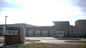
Most of Lancaster is served by the Lancaster Independent School District (LISD). This school district has 11 campuses, including elementary schools, a middle school, a high school, and an alternative school. About 6,800 students were enrolled in LISD in Fall 2013.
A small part of Lancaster is served by the Dallas Independent School District (DISD). Students in this area attend Wilmer-Hutchins Elementary, Kennedy-Curry Middle School, and Wilmer-Hutchins High School.
There are also two public charter schools in the city. Life School Lancaster opened in 2007 for students from kindergarten through sixth grade. The Accelerated Intermediate Academy (AIA) opened an elementary campus in Lancaster in 2012.
Colleges and Universities
Cedar Valley College is a two-year college located near the border of Lancaster and Dallas. It offers job training, continuing education, and college preparation programs. In spring 2013, 6,375 students were enrolled there.
The University of North Texas at Dallas campus is just north of Lancaster.
Public Library
The Lancaster Veterans Memorial Library is located in Lancaster Community Park. It moved to its current 23,000-square-foot building in May 2001. The library has a public meeting room, a reading lounge, and a center for family history research. Lancaster residents can get a free library card to borrow items and use the public computers.
Next to the library is a peaceful garden, which was funded by the Friends of the Lancaster Veterans Memorial Library.
Media
Lancaster's local newspaper is the Focus Daily News. This newspaper serves the southern suburbs of Dallas and is the largest suburban daily newspaper in Texas.
Parks and Recreation
Lancaster's Parks and Recreation Department takes care of the city's parks, recreation programs, and facilities.
Parks
Lancaster has over 600 acres of public parks. The 170-acre Lancaster Community Park is the most popular. It has a 6-acre pond called Contemplation Lake with a fishing pier, lighted fields for football and soccer, and trails for hiking and biking. There is also a playground, an amphitheater, and the Royce Clayton Baseball Field, which can seat 500 people. The Recreation Center, Senior Life Center, Library, and Public Safety Building are all in this park.
Lancaster City Park is another popular park with baseball/softball fields, playgrounds, tennis courts, a basketball court, and a walking trail. It also has an off-leash area for dogs. Cedardale Park and Complex in northern Lancaster has more sports fields and a playground.
Smaller neighborhood parks are located throughout the city. These include J.A. Dewberry Park, Jaycee Park, Kids Square Park, Meadowcreek Park, Rocky Crest Park, Stanford Park, and Verona Park. Heritage Park, with its famous gazebo, is in downtown Lancaster. The newest addition is the 2.4-mile Pleasant Run Hike and Bike Trail, which opened in 2010.
Two nature preserves are in Lancaster: Bear Creek Nature Park and the Ten Mile Creek Preserve. The 189-acre Bear Creek Nature Park has trails for walking and horseback riding, a fishing pond, a climbing rock, and a butterfly garden. It also has an outdoor classroom for kids. The Ten Mile Creek Preserve is mostly undeveloped to protect its natural meadows and woods. It has a two-mile unpaved trail.
Facilities
The Lancaster Recreation Center is 64,000 square feet. It has an indoor water park, a gym, a jogging track, and a fitness area with a dance room. It also has a banquet room and kitchen for events.
The Senior Life Center is a place for adults aged 50 and older. This 11,500-square-foot building opened in 2008. It has a dining hall, classrooms, a computer lab, and a reading lounge. Transportation is available for Lancaster residents who need it.
Country View Golf Course is an 18-hole public golf course. It opened in 1989 and has a chipping area, putting green, and driving range.
Culture
Landmarks
Lancaster has three properties listed on the National Register of Historic Places: the Randlett House, the Captain R. A. Rawlins House, and the W. A. Strain Farm-Strain House.
The Texas Historical Commission has placed 14 historical markers in the Lancaster area. These markers tell the story of important places and events.
- Towns/Communities
- Town of Lancaster (1974) – This marker is in the Historic Town Square and remembers the city's founding.
- Pleasant Run (1974) – This marker is at the Regions Bank building and remembers the former Pleasant Run community.
- Historic Homes
- Captain R. A. Rawlins House (1964)
- W. A. Strain House (1977)
- Winniford House (1994)
- Educational Institution
- Rocky Crest School (2012) – This marker is at the site of a school that served African-American students before schools were integrated.
- Graveyard
- Edgewood Cemetery (1974)
- Places of Worship
- First Presbyterian Church of Lancaster (1976)
- First United Methodist Church of Lancaster (1976)
- First Baptist Church of Lancaster (1977)
- First Christian Church of Lancaster (1979)
- St. Paul Freewill Baptist Church (1985)
- Former Sites
- Site of the Confederate Arms Factory (1936) – This marker is where a gun factory once stood.
- Former Site of Head House (1978)
Infrastructure
Transportation
Lancaster is served by two major highways. Interstate 35E runs along the western side of the city. Interstate 20 runs along the far north side. Interstate 45 is about five miles to the east.
Main roads within the city include State Highway 342 (also called Dallas Avenue), Houston School Road, Pleasant Run Road, and Belt Line Road.
Lancaster Regional Airport is a public airport located two miles southeast of downtown Lancaster. It is used for general aviation, which means it's for private planes and smaller aircraft, not big passenger jets. It also helps reduce air traffic at Dallas–Fort Worth International Airport and Dallas Love Field. The airport has one runway that is 6,502 feet (1,982 meters) long.
The city has public transportation, but it is not part of Dallas Area Rapid Transit (DART). However, the Cedar Valley College campus is served by DART Bus Route 553, which is the southernmost DART stop.
See also
 In Spanish: Lancaster (Texas) para niños
 | William L. Dawson |
 | W. E. B. Du Bois |
 | Harry Belafonte |


