Cedar Hill, Texas facts for kids
Quick facts for kids
Cedar Hill, Texas
|
||
|---|---|---|
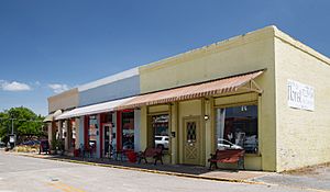
Historic downtown Cedar Hill, Texas
|
||
|
||
| Motto(s):
Where Opportunities Grow Naturally
|
||
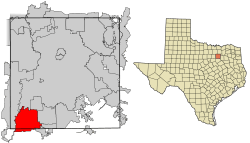
Location of Cedar Hill in Dallas County, Texas
|
||
| Country | United States | |
| State | Texas | |
| Counties | Dallas, Ellis | |
| Government | ||
| • Type | Council-Manager | |
| Area | ||
| • Total | 35.88 sq mi (92.93 km2) | |
| • Land | 35.79 sq mi (92.69 km2) | |
| • Water | 0.09 sq mi (0.24 km2) 0.26% | |
| Elevation | 791 ft (241 m) | |
| Population
(2020)
|
||
| • Total | 49,148 | |
| Demonym(s) | Cedarhillian | |
| Time zone | UTC-6 (CST) | |
| • Summer (DST) | UTC-5 (CDT) | |
| ZIP codes |
75104, 75106
|
|
| Area code(s) | 214, 469, 945, 972 | |
| FIPS code | 48-13492 | |
| GNIS feature ID | 2409416 | |
Cedar Hill is a city in Texas, located in both Dallas and Ellis counties. It's about 16 miles southwest of downtown Dallas. You'll find it near Joe Pool Lake and Cedar Hill State Park. In 2020, nearly 50,000 people lived there. Cedar Hill is a suburb of Dallas. It's part of the "Best Southwest" area, along with DeSoto, Duncanville, and Lancaster.
Long ago, Cedar Hill was on the Chisholm Trail, a famous cattle route. It was even the temporary capital of Dallas County. But in 1856, a powerful tornado hit, destroying many buildings. After that, the county capital moved to Dallas.
Contents
History of Cedar Hill
Cedar Hill was started around 1846 by settlers from the Peters Colony. These pioneers came from places like Kentucky and Alabama. About 197 families and 184 single men settled here. This made Cedar Hill the biggest settlement in the area at that time.
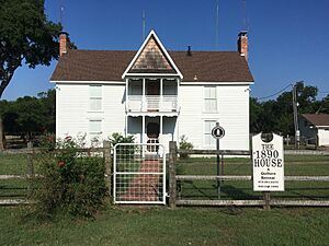
The city has five homes listed on the National Register of Historic Places. Four historical buildings are on the Texas Historical Commission's list. There are also two graveyards called "Historical Texas Cemeteries." One of these is thought to be the oldest integrated cemetery in Dallas County.
The 1856 Tornado Disaster
On April 29, 1856, a tornado struck Cedar Hill. It killed at least nine people and destroyed almost all buildings. Livestock also died. Only two structures were left standing.
One survivor was Robert Crawford, a teacher and pastor. He gave four acres of his land for a public graveyard. The nine tornado victims were buried there. This graveyard was lost for about 100 years. It was found again and certified in 2006. It is now called the Crawford Tornado Graveyard. A special marker was placed there on April 29, 2012. This was 156 years after the tornado.
The Cedar Hill Bank Robbery
On October 8, 1932, the First State Bank of Cedar Hill was robbed. The robber was Raymond Hamilton, who worked with Bonnie and Clyde. He took the money and locked the bank workers in the vault.
Later, Hamilton heard that some money might have been hidden. So, he came back and robbed the bank again! These two robberies caused the bank to lose all its money. It had to close for good.
Raymond Hamilton was later caught and put in Eastham Prison. But on January 17, 1934, Bonnie and Clyde broke him out. The gang was known to have secret hideouts in the Cedar Hill area. Hamilton was caught again on April 24, 1934.
The building where the robbery happened is still in downtown Cedar Hill. Today, it is a barbershop. In 2008, the city recognized it as a historic place.
Geography of Cedar Hill
Cedar Hill is located in North Texas. It is next to Grand Prairie to the west. Dallas is to the north, and Duncanville is to the northeast. DeSoto is to the east. Glenn Heights and Ovilla are to the southeast. Midlothian is to the south. Most of Cedar Hill is in Dallas County. A small part is in Ellis County.
The city covers about 35.88 square miles (92.93 square kilometers). Most of this area is land. Only a tiny part, about 0.26%, is water.
Cedar Hill is sometimes called the "hill country of Dallas." This is because it has many hills, like the "hill country" near Austin. The city has many native eastern red cedar trees. It stands about 800 feet (244 meters) above sea level. This is the highest point between the Red River and the Gulf Coast.
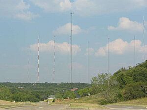
Because it is so high up, many local radio and TV stations have their antennas here. Weather radar equipment for tracking tornadoes is also on these tall towers. These towers can reach thousands of feet into the air.
The city sits on a type of limestone called "Austin chalk." This is covered with a clay topsoil. The western part of the city, near Lake Ridge, is on a different type of rock called Eagle Ford shale. This area is around Joe Pool Lake.
Population and People
| Historical population | |||
|---|---|---|---|
| Census | Pop. | %± | |
| 1940 | 476 | — | |
| 1950 | 732 | 53.8% | |
| 1960 | 1,848 | 152.5% | |
| 1970 | 2,610 | 41.2% | |
| 1980 | 6,849 | 162.4% | |
| 1990 | 19,976 | 191.7% | |
| 2000 | 32,093 | 60.7% | |
| 2010 | 45,028 | 40.3% | |
| 2020 | 49,148 | 9.1% | |
| 2023 (est.) | 48,411 | 7.5% | |
| U.S. Decennial Census 2010 2020 |
|||
| Race / Ethnicity (NH = Non-Hispanic) | Pop 2010 | Pop 2020 | % 2010 | % 2020 |
|---|---|---|---|---|
| White alone (NH) | 11,604 | 8,646 | 25.77% | 17.59% |
| Black or African American alone (NH) | 23,146 | 25,790 | 51.40% | 52.47% |
| Native American or Alaska Native alone (NH) | 134 | 157 | 0.30% | 0.32% |
| Asian alone (NH) | 893 | 1,035 | 1.98% | 2.11% |
| Pacific Islander alone (NH) | 18 | 22 | 0.04% | 0.04% |
| Some Other Race alone (NH) | 63 | 200 | 0.14% | 0.41% |
| Mixed Race or Multi-Racial (NH) | 765 | 1,417 | 1.70% | 2.88% |
| Hispanic or Latino (any race) | 8,405 | 11,881 | 18.67% | 24.17% |
| Total | 45,028 | 49,148 | 100.00% | 100.00% |
Cedar Hill has grown a lot as a suburb of Dallas. In 1950, only 732 people lived there. By 2020, the population had grown to 49,148 people.
In 2020, the people living in Cedar Hill were from many different backgrounds. About 52.47% were Black or African American. About 24.17% were Hispanic or Latino American. About 17.59% were non-Hispanic white. The rest were multiracial, Asian American, or other groups. This mix of cultures shows how the U.S. population is changing.
In 2020, the average income for a household in Cedar Hill was $75,715.
Economy and Businesses
In the early 1990s, Cedar Hill was growing fast. People wanted to make sure the city grew in a good way. So, a group was formed to plan for economic development. They asked residents what they wanted for Cedar Hill's future.
In 1994, voters approved a special sales tax. This money would help fund economic growth. The Cedar Hill Economic Development Corporation (EDC) was then started. They help bring new businesses to the city and keep existing ones.
Since 2000, many new stores have opened. The Plaza at Cedar Hill opened in 2000. It has many large and small shops. Later that year, The Cedar Hill Crossing was built. In 2003, Cedar Village was created. This area connects a new city hall and historic downtown with shops, homes, and entertainment.
Other shopping centers like Pleasant Run Towne Crossing and Cedar Hill Pointe also opened. Hillside Village (formerly Uptown Village) opened in 2008. This large shopping center has many stores and restaurants. It is a popular place for shopping and dining.
The city is also working on a plan called the City Center Vision Plan. This plan aims to make Cedar Hill's downtown a lively place. It will have places to walk, shops, and homes. In 2014, a large apartment complex called Midtown Apartments was built. It gives residents easy access to outdoor activities, shops, and restaurants.
Education in Cedar Hill
Most students in Cedar Hill go to schools in the Cedar Hill Independent School District. Some parts of the city are served by the Duncanville Independent School District or the Midlothian Independent School District.
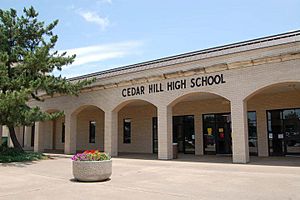
Students in the Cedar Hill ISD attend Cedar Hill High School or Cedar Hill Collegiate High School. Those in Duncanville ISD go to Duncanville High School. Students in Midlothian ISD go to Midlothian High School. There are also charter schools like Life School and private schools like Trinity Christian School – Cedar Hill.
For college, residents in Dallas County can attend Dallas College. Those in Ellis County can go to Navarro College.
Arts and Nature
Nature Preserves and Parks
Cedar Hill has set aside a lot of land for parks and nature. About 20% of the city is parks and green space. There are 3,000 acres of nature reserves. These include Dogwood Canyon and Cedar Hill State Park.
Dogwood Canyon Natural Area
Dogwood Canyon was formed where two different natural areas meet. One is the Blackland Prairie, which covers most of Dallas County. The other is the white rock of the Austin Chalk deposits.
Many animals live in the canyon. Birds like the painted bunting and black-capped vireo can be seen. The golden-cheeked warbler, which is an endangered bird, also lives here. You might also spot bobcats, coyotes, lizards, and snakes.
The canyon is named for the beautiful flowering Dogwood trees. Other plants like the White trout-lily grow here. There are also rare types of orchids.
Cedar Hill State Park
Cedar Hill State Park opened in 1991. It is on the northeast side of Joe Pool Lake. The park has 1,826 acres of land and many miles of shoreline. It's a special place where rolling tallgrass prairie meets rugged limestone escarpment.
The park protects important parts of the native tallgrass prairie. Long ago, a huge tallgrass prairie stretched from Texas to Canada. Today, less than one percent of it is left. The park has rare grasses like Indian grass, little bluestem, and big bluestem. They have also planted Eastern gamma grass and meadow pinks.
In the park's wooded hills, you can find bobcats, coyotes, foxes, and raccoons. The lake is great for fishing. You can catch largemouth bass, white bass, crappie, and catfish. The park is also home to about 200 types of birds. The painted bunting is a popular bird to see from May to August.
Joe Pool Lake
Cedar Hill is right next to Joe Pool Lake. The lake was created in 1986. It covers 6,469 acres and is up to 75 feet deep. You can get to Joe Pool Lake through Cedar Hill State Park. There are also three other parks along its edges.
Sports and Recreation
Cedar Hill hosts many sports events. The city has several sports complexes. These include 21 baseball and softball fields. There are also 18 soccer fields, 7 basketball courts, and 6 tennis courts. You can find 4 football fields and a 36-hole disc golf course too.
Points of Interest in Cedar Hill
Tall Towers of Cedar Hill
In the 1950s, Cedar Hill became home to what was called Hill Tower. Cedar Hill's high elevation, about 880 feet above sea level, made it perfect for TV and FM radio towers. These towers could reach both Fort Worth and Dallas. Hill Tower was the first tower shared by two TV stations at once.
At that time, KRLD-TV (CBS) and WFAA-TV (ABC) were top Dallas TV stations. They both wanted the same tower spot. So, they decided to build Hill Tower together. The tower was over 1,500 feet tall. It had an 80-foot platform with two antennas, one for each station. People called it 'the candelabra'.
Later, WBAP-TV (NBC) also moved its tower to Cedar Hill. Today, Cedar Hill has the most radio and TV antennas in the county, with 14 towers. You can see these towers from 20 miles away on a clear night. They are a landmark for travelers and pilots.
Penn Farm Agricultural History Center
Farmers like John Wesley Penn used the land's natural resources. They built farms and provided for their families. The Penn family lived and raised animals on the native prairie grasses for over a hundred years. During that time, most of the tallgrass prairie in Dallas County disappeared. It was plowed for crops like wheat or cotton. But because Cedar Hill is rocky and hilly, the prairie at Penn Farm survived.
The Penn Farm Agricultural History Center was created from parts of Penn Farm. The farm dates back to the 1850s. It is located inside Cedar Hill State Park. The center teaches people about early life in Cedar Hill. It also shows how human inventions changed the tallgrass prairie. Many original buildings are still standing. They show how the Penn family adapted their tools over time.
Dogwood Canyon Audubon Center
The Dogwood Canyon Audubon Center was built through a partnership. It was a joint effort between Cedar Hill and the National Audubon Society. The center officially opened in 2011.
The visitor center is very eco-friendly. It has a special certification for being green. This means it uses energy, water, and materials wisely. It also uses other sustainable methods.
In 2015, the center worked with the Cedar Hill Independent School District. They studied how outdoor science education helps students. Fifth-grade students from Cedar Hill ISD took part. They had weekly lessons at the Audubon Center. These students scored 20% higher on related tests than those who did not participate. This was the first study of its kind in Texas.
Recreation and Outdoor Fun
Parks for Play
Cedar Hill manages 32 park properties. These include 6 community parks and 17 neighborhood parks. There is also 1 special purpose park, 3 nature preserves, and 4 greenbelts.
Hike and Bike Trails
Cedar Hill has over 45 miles of trails for walking and biking. Some newer trails include Pleasant Run Trail and Lake Ridge Hike and Bike Trail. The Red Oak Creek Trail is also a recent addition.
The DORBA Trail is the longest trail in Cedar Hill State Park. It is for both hiking and biking. This trail was created by the Dallas Off-Road Bicycle Association. It is known as one of the best mountain biking trails in Texas.
An ADA accessible trail is available at the Dogwood Canyon Audubon Center.
Several creeks are located around the state park, including Baggett Branch.
Images for kids
See also
 In Spanish: Cedar Hill (Texas) para niños
 | Janet Taylor Pickett |
 | Synthia Saint James |
 | Howardena Pindell |
 | Faith Ringgold |


