
Dallam County, Texas facts for kids
Quick facts for kids
Dallam County
|
|
|---|---|

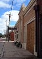
1922 Dallam County Courthouse in Dalhart
|
|

Location within the U.S. state of Texas
|
|
 Texas's location within the U.S. |
|
| Country | |
| State | |
| Founded | 1891 |
| Seat | Dalhart |
| Largest city | Dalhart |
| Area | |
| • Total | 1,505 sq mi (3,900 km2) |
| • Land | 1,503 sq mi (3,890 km2) |
| • Water | 2.0 sq mi (5 km2) 0.1% |
| Population
(2020)
|
|
| • Total | 7,115 |
| • Density | 4.7/sq mi (1.8/km2) |
| Time zone | UTC−6 (Central) |
| • Summer (DST) | UTC−5 (CDT) |
| Congressional district | 13th |
Dallam County is a county located in the far northwest part of Texas, a state in the United States. In 2020, about 7,115 people lived there. The main town and county seat is Dalhart. The county was created in 1876 and officially organized in 1891. It is named after James Wilmer Dallam, who was a lawyer and also published newspapers.
Contents
History of Dallam County
Dallam County was first formed in 1876 from parts of Bexar County. It was named after James Wilmer Dallam, a lawyer famous for making the first collection of Texas laws. The first people to settle in this area arrived around 1870. This led to conflicts with the native Comanche and Kiowa tribes, known as the Red River War in 1874 and 1875.
Around 1900, a railroad company, the Chicago, Rock Island and Pacific Railroad, built tracks through the county. These tracks connected Liberal, Kansas, to Tucumcari, New Mexico. Where these new tracks met another railway, the Fort Worth and Denver Railway, a town was started. It was named Dalhart, combining letters from Dallam County and Hartley County, as the town sits between both. This small railroad stop quickly grew into a large town. In 1903, Dalhart became the official county seat.
Dallam County was one of the places hit hardest by the Dust Bowl. This was a time in the 1930s when severe dust storms caused by drought and poor farming methods damaged a lot of land.
Geography of Dallam County
Dallam County covers about 1,505 square miles. Most of this area is land, with only a small amount of water.
Dallam County is special because it borders two other U.S. states. These are Oklahoma to the north and New Mexico to the west. This means it's part of a "tripoint" where Texas, Oklahoma, and New Mexico meet.
Main Roads in Dallam County
 U.S. Highway 54
 U.S. Highway 87
 U.S. Highway 287
 U.S. Highway 385
 State Highway 102
Neighboring Counties
- Cimarron County, Oklahoma (north)
- Sherman County (east)
- Moore County (southeast)
- Hartley County (south)
- Union County, New Mexico (west)
Protected Natural Areas
- Rita Blanca National Grassland (part of this protected area is in Dallam County)
Population of Dallam County
The population of Dallam County has changed over the years. Here's how it has grown or shrunk:
| Historical population | |||
|---|---|---|---|
| Census | Pop. | %± | |
| 1890 | 112 | — | |
| 1900 | 146 | 30.4% | |
| 1910 | 4,001 | 2,640.4% | |
| 1920 | 4,528 | 13.2% | |
| 1930 | 7,830 | 72.9% | |
| 1940 | 6,494 | −17.1% | |
| 1950 | 7,640 | 17.6% | |
| 1960 | 6,302 | −17.5% | |
| 1970 | 6,012 | −4.6% | |
| 1980 | 6,531 | 8.6% | |
| 1990 | 5,461 | −16.4% | |
| 2000 | 6,222 | 13.9% | |
| 2010 | 6,703 | 7.7% | |
| 2020 | 7,115 | 6.1% | |
| U.S. Decennial Census 1850–2010 2010 2020 |
|||
In 2020, there were 7,115 people living in Dallam County. The population density was about 4.7 people per square mile. The median age in the county was 31 years old. This means half the people were younger than 31 and half were older.
Education in Dallam County
Students in Dallam County attend schools in these districts:
- Dalhart Independent School District
- Stratford Independent School District
- Texline Independent School District
Towns and Communities
Cities
- Dalhart (This is the county seat and is partly in Hartley County)
Towns
Small Communities (Unincorporated)
Old or Abandoned Towns (Ghost Towns)
- Chamberlin
- Perico
- Ware
Images for kids
-
The XIT Museum in Dalhart
-
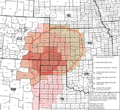
Map showing the area affected by the 1930s Dust Bowl

.svg)
See also
 In Spanish: Condado de Dallam para niños
