
Sherman County, Texas facts for kids
Quick facts for kids
Sherman County
|
|
|---|---|

Sherman County Courthouse
|
|

Location within the U.S. state of Texas
|
|
 Texas's location within the U.S. |
|
| Country | |
| State | |
| Founded | 1889 |
| Named for | Sidney Sherman |
| Seat | Stratford |
| Largest city | Stratford |
| Area | |
| • Total | 923 sq mi (2,390 km2) |
| • Land | 923 sq mi (2,390 km2) |
| • Water | 0.2 sq mi (0.5 km2) 0.02% |
| Population
(2020)
|
|
| • Total | 2,782 |
| • Density | 3/sq mi (1/km2) |
| Time zone | UTC−6 (Central) |
| • Summer (DST) | UTC−5 (CDT) |
| Congressional district | 13th |
Sherman County is a county located in the northern part of Texas, a state in the United States. In 2020, about 2,782 people lived there. The main town and county seat of Sherman County is Stratford.
Sherman County was officially created in 1876 and started operating in 1889. It is named after Sidney Sherman, a brave soldier who fought in the Texas Revolution. It's interesting to know that while Sherman County and the city of Sherman, Texas are both named after Sidney Sherman, they are very far apart. The city of Sherman is in Grayson County, about 430 miles to the southeast.
Contents
What is Sherman County Like?
Sherman County covers a total area of about 923 square miles. Most of this area is land, with only a tiny bit (0.02%) covered by water. It's a large county, but not many people live there.
Main Roads in Sherman County
Several important highways pass through Sherman County, helping people travel and transport goods. These include:
 U.S. Highway 54
 U.S. Highway 287
 State Highway 15
Neighboring Counties
Sherman County shares its borders with several other counties and even another state. These include:
- Texas County, Oklahoma (to the north)
- Hansford County (to the east)
- Moore County (to the south)
- Dallam County (to the west)
- Cimarron County, Oklahoma (to the northwest)
- Hartley County (to the southwest)
- Hutchinson County (to the southeast)
Who Lives in Sherman County?
The number of people living in Sherman County has changed over the years. In 1890, only 34 people lived there! The population grew over time, reaching its highest in 1970 with 3,657 people. By 2020, the population was 2,782.
| Historical population | |||
|---|---|---|---|
| Census | Pop. | %± | |
| 1890 | 34 | — | |
| 1900 | 104 | 205.9% | |
| 1910 | 1,476 | 1,319.2% | |
| 1920 | 1,473 | −0.2% | |
| 1930 | 2,314 | 57.1% | |
| 1940 | 2,026 | −12.4% | |
| 1950 | 2,443 | 20.6% | |
| 1960 | 2,605 | 6.6% | |
| 1970 | 3,657 | 40.4% | |
| 1980 | 3,174 | −13.2% | |
| 1990 | 2,858 | −10.0% | |
| 2000 | 3,186 | 11.5% | |
| 2010 | 3,034 | −4.8% | |
| 2020 | 2,782 | −8.3% | |
| U.S. Decennial Census 1850–2010 2010 2020 |
|||
Diversity in Sherman County
Sherman County is home to people from many different backgrounds. The U.S. Census collects information about race and ethnicity. In 2020, about 48.96% of the people were White (not Hispanic or Latino). A large part of the population, about 47.27%, identified as Hispanic or Latino.
Other groups include Black or African American, Native American, Asian, and people of two or more races. This mix of cultures makes Sherman County a diverse place.
Families and Age Groups
In 2000, there were 1,124 households in the county. Many of these households (68.0%) were married couples living together. About 40.7% of households had children under 18 living with them.
The county's population has a mix of ages. In 2000, about 31.4% of the people were under 18 years old. About 13.6% were 65 years or older. The average age in the county was 34 years old.
Towns and Communities
Sherman County has a few towns and one former town.
Cities in Sherman County
- Stratford: This is the largest town and the county seat. It's where the main county government offices are located.
- Texhoma: This city is unique because it's split between Texas and Oklahoma. Part of it is in Sherman County, Texas, and the other part is in Oklahoma.
Former Town
- Coldwater: This was once a town in Sherman County, but it is now a ghost town, meaning it is no longer inhabited.
Images for kids
-
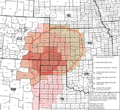
This map shows the area affected by the Dust Bowl in the 1930s, which included parts of Sherman County.
.svg)
See also
 In Spanish: Condado de Sherman (Texas) para niños
