
Grayson County, Texas facts for kids
Quick facts for kids
Grayson County
|
||
|---|---|---|

The Grayson County Courthouse in Sherman
|
||
|
||

Location within the U.S. state of Texas
|
||
 Texas's location within the U.S. |
||
| Country | ||
| State | ||
| Founded | 1846 | |
| Named for | Peter Wagener Grayson | |
| Seat | Sherman | |
| Largest city | Sherman | |
| Area | ||
| • Total | 979 sq mi (2,540 km2) | |
| • Land | 933 sq mi (2,420 km2) | |
| • Water | 46 sq mi (120 km2) 4.7% | |
| Population
(2020)
|
||
| • Total | 135,543 | |
| • Density | 138.45/sq mi (53.456/km2) | |
| Time zone | UTC−6 (Central) | |
| • Summer (DST) | UTC−5 (CDT) | |
| Congressional district | 4th | |

Grayson County is a county in the state of Texas. In 2020, about 135,543 people lived there. The main city and county seat is Sherman.
The county was started in 1846. It is named after Peter Wagener Grayson, who was an attorney general for the Republic of Texas. Grayson County is part of the Sherman-Denison metropolitan area. This area is also part of the larger Dallas-Fort Worth-Arlington region.
Grayson County is located right on the border with Oklahoma. It is part of the Texoma area, which is close to Lake Texoma and the Red River.
Contents
History of Grayson County
Early Settlers and Growth
The first people known to live in what is now Grayson County were Native American groups like the Caddo, Tonkawa, Ionis, and Kichai. These groups grew crops and traded with Spanish and French people at trading posts along the Red River. Trading posts were set up in places like Preston Bend, Warren, and Pilot Grove in the 1830s.
In the early 1840s, more people started moving to the area near the Red River. This happened after Peters Colony was established. On March 17, 1846, the Texas State Legislature created Grayson County from Fannin County. The county seat, Sherman, was also named by the state.
During the 1850s, trading and farming became very important in Preston Bend. This was helped by Preston Road, which was the first trail in Texas that went from Preston Bend all the way to Austin. The county grew even more when Sherman became a stop on the Butterfield Overland Mail route in 1856.
Civil War and Reconstruction
When the Civil War began, people in Grayson County had different ideas about secession (leaving the Union). In 1861, the county voted to stay in the Union. However, a very sad event called the Great Hanging at Gainesville happened nearby, where more than 40 men were killed. This event caused a lot of division. Many men from Grayson County fought for the Confederacy.
After the Civil War, during the Reconstruction era, Grayson County and much of Texas faced economic problems. Moving cattle herds north along Preston Road helped bring in money for the county during this time.
Railroads and New Towns
Grayson County grew a lot in the 1870s and 1880s. This was because two major railroads, the Houston and Texas Central and the Missouri, Kansas, and Texas, started operating in the county in 1872. With the railroads, cotton became the most important farm product. Many towns were founded during this time, including Denison, Van Alstyne, Howe, Whitewright, Pottsboro, and Tom Bean.
In 1879, a group of early settlers in North Texas formed the Old Settlers Association of North Texas in Grayson County. They bought 26 acres of land and continued to meet every year for many years.
Important Events of the 20th Century
On May 15, 1896, a very strong tornado hit Sherman. It was an F5 tornado, which is the strongest kind. It was 400 yards wide and 28 miles long. The tornado killed 73 people and injured 200. About 50 homes were destroyed.
In 1930, during the Sherman Riot of 1930, the county's old courthouse from 1876 was burned down. Texas Governor Dan Moody sent National Guard troops to control the situation. The current Grayson County courthouse was finished in 1936.
In 1931, there was a disagreement called the Bridge War (also known as the Red River Bridge War). It was a conflict between Oklahoma and Texas over a toll bridge and a new free bridge crossing the Red River. No one was hurt in this "bloodless" conflict.
In 1938, the U.S. Congress approved building a dam on the Red River. This dam, now called Denison Dam, was partly built by German prisoners of war during World War II. Lake Texoma was formed by this dam and is used for fun activities, watering crops, and making electricity.
Perrin Air Force Base was built in 1941. When the base closed in 1971, it was a big change for the county. However, the base was turned into a civilian airport, North Texas Regional Airport - Perrin Field, which helped lessen the impact.
The Eisenhower Birthplace State Historic Site in Denison is the birthplace of Dwight D. Eisenhower, who later became a U.S. President. The site was bought and fixed up in 1952. Today, a private group takes care of it.
Grayson County is special because it is the only county in Texas where deer can only be hunted with bows, no matter the season.
Geography
Grayson County covers a total area of 979 square miles. About 933 square miles is land, and 46 square miles (4.7%) is water.
Major Highways
 U.S. Highway 69
 U.S. Highway 75
 U.S. Highway 82
 U.S. Highway 377
 State Highway 5
 State Highway 11
 State Highway 56
 State Highway 91
 State Highway 160
 State Highway 289
 Spur 503
Neighboring Counties
- Marshall County, Oklahoma (north)
- Bryan County, Oklahoma (northeast)
- Fannin County (east)
- Collin County (south)
- Denton County (southwest)
- Cooke County (west)
- Love County, Oklahoma (northwest)
Protected Areas
Communities
Cities
- Denison
- Dorchester
- Gunter
- Knollwood
- Sadler
- Sherman (county seat)
- Southmayd
- Tom Bean
- Trenton (mostly in Fannin County)
- Van Alstyne (small part in Collin County)
- Whitesboro
Towns
- Bells
- Collinsville
- Howe
- Pottsboro
- Tioga
- Whitewright (small part in Fannin County)
Census-designated places
Other Unincorporated Communities
Population Information
| Historical population | |||
|---|---|---|---|
| Census | Pop. | %± | |
| 1850 | 2,008 | — | |
| 1860 | 8,184 | 307.6% | |
| 1870 | 14,387 | 75.8% | |
| 1880 | 38,108 | 164.9% | |
| 1890 | 53,211 | 39.6% | |
| 1900 | 63,661 | 19.6% | |
| 1910 | 65,996 | 3.7% | |
| 1920 | 74,165 | 12.4% | |
| 1930 | 65,843 | −11.2% | |
| 1940 | 69,499 | 5.6% | |
| 1950 | 70,467 | 1.4% | |
| 1960 | 73,043 | 3.7% | |
| 1970 | 83,225 | 13.9% | |
| 1980 | 89,796 | 7.9% | |
| 1990 | 95,021 | 5.8% | |
| 2000 | 110,595 | 16.4% | |
| 2010 | 120,877 | 9.3% | |
| 2020 | 135,543 | 12.1% | |
| U.S. Decennial Census 1850–2010 2010 2020 |
|||
| Race / Ethnicity (NH = Non-Hispanic) | Pop 2000 | Pop 2010 | Pop 2020 | % 2000 | % 2010 | % 2020 |
|---|---|---|---|---|---|---|
| White alone (NH) | 92,857 | 95,103 | 95,211 | 83.96% | 78.68% | 70.24% |
| Black or African American alone (NH) | 6,385 | 6,938 | 7,448 | 5.77% | 5.74% | 5.49% |
| Native American or Alaska Native alone (NH) | 1,314 | 1,603 | 1,876 | 1.19% | 1.33% | 1.38% |
| Asian alone (NH) | 613 | 1,034 | 1,958 | 0.55% | 0.86% | 1.44% |
| Pacific Islander alone (NH) | 45 | 38 | 58 | 0.04% | 0.03% | 0.04% |
| Other race alone (NH) | 34 | 77 | 348 | 0.03% | 0.06% | 0.26% |
| Mixed race or Multiracial (NH) | 1,828 | 2,396 | 7,776 | 1.65% | 1.98% | 5.74% |
| Hispanic or Latino (any race) | 7,519 | 13,688 | 20,868 | 6.80% | 11.32% | 15.40% |
| Total | 110,595 | 120,877 | 135,543 | 100.00% | 100.00% | 100.00% |
In 2000, there were 110,595 people living in Grayson County. By 2020, the population had grown to 135,543 people. The tables above show how the population has changed over time and the different ethnic groups living in the county.
Images for kids
-
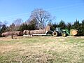
A rancher transports round bales of hay down a rural road in Grayson County, Texas. The economy of the county relies in part upon agriculture and ranchers.

See also
 In Spanish: Condado de Grayson (Texas) para niños
