
Love County, Oklahoma facts for kids
Quick facts for kids
Love County
|
|
|---|---|

Love County Courthouse in October 2014
|
|

Location within the U.S. state of Oklahoma
|
|
 Oklahoma's location within the U.S. |
|
| Country | |
| State | |
| Founded | 1907 |
| Named for | Overton Love, a judge of the Chickasaw Nation |
| Seat | Marietta |
| Largest city | Marietta |
| Area | |
| • Total | 532 sq mi (1,380 km2) |
| • Land | 514 sq mi (1,330 km2) |
| • Water | 18 sq mi (50 km2) 3.5%% |
| Population
(2020)
|
|
| • Total | 10,146 |
| • Density | 19.071/sq mi (7.364/km2) |
| Time zone | UTC−6 (Central) |
| • Summer (DST) | UTC−5 (CDT) |
| Congressional district | 4th |
Love County is a county located in the southern part of Oklahoma, a state in the United States. In 2020, about 10,146 people lived there. The main town and county seat is Marietta.
Love County was officially created in 1907 when Oklahoma became a state. It was named after Overton Love. He was an important leader, farmer, and businessman from the Chickasaw Nation.
For visitors, the Oklahoma Department of Tourism calls Love County part of 'Chickasaw Country'. It is also part of the Texoma region, which is near Lake Texoma.
Contents
History of Love County
Early Days and Native American Lands
In 1803, the Louisiana Purchase added a huge amount of land to the United States. This land included almost all of what is now Oklahoma. Explorers and traders soon began traveling through the area. They hoped to find new trade routes.
The Quapaw people were the main Native American group living south of the Canadian River. In 1818, the Quapaws gave their land to the U.S. government. The Choctaw people then moved into this area in the early 1830s. A few years later, the Chickasaw people were given land in the middle of the Choctaw territory. This happened between 1837 and 1838.
Overton Love and Early Settlements
Overton Love was one of the first Chickasaw people to settle in what is now Love County. He was 20 years old when he arrived in the area in 1843. He had traveled from Mississippi. His settlement became known as Love's Valley. This area is about 6 miles (9.7 km) east of the modern town of Marietta.
Overton Love became a very successful farmer and cattle rancher. He owned a large amount of land near the Red River. He also became an important political leader for the Chickasaw Nation. He served as a judge and was a member of their government council.
Before Oklahoma became a state, this area was part of Pickens County. This was in the Chickasaw Nation, which was part of Indian Territory. There were three main towns: Marietta (founded 1887), Leon (established 1883), and Thackerville (established 1882). There were also smaller communities like Burneyville and Overbrook.
Geography of Love County
Land and Water Features
Love County covers about 532 square miles (1,378 km²). Most of this area, about 514 square miles (1,331 km²), is land. The remaining 18 square miles (47 km²) is water. This means about 3.5% of the county is covered by water. Love County is one of the smallest counties in Oklahoma by land area.
The county is located in a region called the Red River Plains. The land here is gently rolling or hilly. The Red River flows through the county. Other smaller rivers and streams like Simon Creek, Walnut Bayou, Hickory Creek, and Mud Creek also drain the area. Two important lakes are partly in Love County: Lake Murray is on the northeastern border, and Lake Texoma is on the southern border.

Neighboring Counties
Love County shares borders with several other counties:
- Carter County (to the north)
- Marshall County (to the east)
- Cooke County, Texas (to the south)
- Montague County, Texas (to the southwest)
- Jefferson County (to the northwest)
Population of Love County
How Many People Live Here?
The population of Love County has changed over the years. Here's a look at how many people have lived there during different census counts:
- 1910: 10,236 people
- 1920: 12,433 people
- 1930: 9,639 people
- 1940: 11,433 people
- 1950: 7,721 people
- 1960: 5,862 people
- 1970: 5,637 people
- 1980: 7,469 people
- 1990: 8,157 people
- 2000: 8,831 people
- 2010: 9,423 people
- 2020: 10,146 people
In 2000, there were 8,831 people living in Love County. There were 3,442 households, which are groups of people living together. About 31.7% of these households had children under 18 years old. The average age of people in the county was 39 years old.
Economy of Love County
Main Industries and Jobs
Love County is home to the Winstar World Casino. This large casino is located near the border with Texas. The Chickasaw Nation operates the casino. It is the biggest private employer in Love County, meaning it provides the most jobs.
Farming and ranching have always been very important to the county's economy. People have been growing crops and raising animals here since the county was first settled. The county also produces natural gas, which is used for energy.
Education in Love County
Love County has several school districts that serve its students:
- Turner Public Schools
- Marietta Public Schools
- Thackerville Public Schools
- Greenville Public Schools
Transportation in Love County
Major Roads
Several important highways run through Love County, making it easy to travel to other areas:
 Interstate 35
 U.S. Highway 77
 State Highway 32
 State Highway 76
 State Highway 77S
 State Highway 89
 State Highway 96
Airports
There are a few airports in Love County for small planes:
- Falconhead Airport (37K) in Burneyville
- McGehee Catfish Restaurant Airport (T40) in Marietta (now closed)
- McGehee Catfish Restaurant Airport (4O2) in Marietta (now closed)
Communities in Love County
City
- Marietta (This is the county seat, where the main government offices are.)
Towns
Unincorporated Communities
These are smaller communities that are not officially organized as cities or towns:
Census-Designated Places
These are areas that the U.S. Census Bureau defines for gathering population data, but they are not official towns:
- Burneyville
- Greenville
Images for kids
-
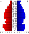
Age pyramid for Love County, Oklahoma, based on census 2000 data.

See also
 In Spanish: Condado de Love para niños
