
Montague County, Texas facts for kids
Quick facts for kids
Montague County
|
|
|---|---|
|
County
|
|

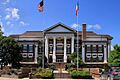
The Montague County Courthouse in Montague
|
|

Location within the U.S. state of Texas
|
|
 Texas's location within the U.S. |
|
| Country | |
| State | |
| Founded | 1858 |
| Named for | Daniel Montague |
| Seat | Montague |
| Largest city | Bowie |
| Area | |
| • Total | 938 sq mi (2,430 km2) |
| • Land | 931 sq mi (2,410 km2) |
| • Water | 7.4 sq mi (19 km2) 0.8% |
| Population
(2020)
|
|
| • Total | 19,965 |
| • Density | 21.285/sq mi (8.218/km2) |
| Time zone | UTC−6 (Central) |
| • Summer (DST) | UTC−5 (CDT) |
| Congressional district | 13th |
Montague County is a county located in the state of Texas. It was created in 1857 and officially started working in 1858. The county is named after Daniel Montague, who was a land surveyor and a soldier.
As of the 2020 census, about 19,965 people live in Montague County. The main town and county seat where the county government is located is Montague.
Contents
History of Montague County
In the middle to late 1800s, Montague County was home to an important trading post. This place was called Red River Station. It was set up near the Red River by Jesse Chisholm.
The Chisholm Trail and Cattle Drives
Jesse Chisholm was a Cherokee merchant. He was also a very important interpreter for the Republic of Texas and the United States. With the help of Black Bear, a Lenape guide, Chisholm explored and developed a famous path. This path became known as the Chisholm Trail. It stretched north through Indian Territory (which is now Oklahoma) and into Kansas.
After the American Civil War, ranchers in Texas had a problem. There were too many cattle, and prices for beef were very low. They learned that people in the East wanted beef and would pay high prices. So, ranchers started to move their cattle to Kansas. In Kansas, the cattle could be loaded onto trains and sent East.
Red River Station in Montague County became the starting point for these cattle drives. Thousands of Texas Longhorn cattle were gathered there each year. Cowboys from East and West Texas would bring their cattle. Then, they would drive them overland all the way to Kansas. It's estimated that about five million cattle were moved north this way. This helped ranchers get much better prices for their cattle. Later, when railroads were built into Texas, the long cattle drives to Kansas were no longer needed.
Geography of Montague County
Montague County covers a total area of about 938 square miles. Most of this area, about 931 square miles, is land. The remaining 7.4 square miles, or 0.8%, is covered by water.
Counties Next to Montague County
Montague County shares its borders with several other counties:
- Jefferson County, Oklahoma (to the north)
- Love County, Oklahoma (to the northeast)
- Cooke County (to the east)
- Wise County (to the south)
- Jack County (to the southwest)
- Clay County (to the west)
Protected Natural Areas
Part of the Lyndon B. Johnson National Grassland is located within Montague County. This is a special area managed for conservation and public use.
Population and People
The population of Montague County has changed over the years. Here's how it has grown:
| Historical population | |||
|---|---|---|---|
| Census | Pop. | %± | |
| 1860 | 849 | — | |
| 1870 | 890 | 4.8% | |
| 1880 | 11,257 | 1,164.8% | |
| 1890 | 18,863 | 67.6% | |
| 1900 | 24,800 | 31.5% | |
| 1910 | 25,123 | 1.3% | |
| 1920 | 22,200 | −11.6% | |
| 1930 | 19,159 | −13.7% | |
| 1940 | 20,442 | 6.7% | |
| 1950 | 17,070 | −16.5% | |
| 1960 | 14,893 | −12.8% | |
| 1970 | 15,326 | 2.9% | |
| 1980 | 17,410 | 13.6% | |
| 1990 | 17,274 | −0.8% | |
| 2000 | 19,117 | 10.7% | |
| 2010 | 19,719 | 3.1% | |
| 2020 | 19,965 | 1.2% | |
| 2021 (est.) | 20,409 | 3.5% | |
| U.S. Decennial Census 1850–2010 2010 2020 |
|||
Diversity in Montague County
The people living in Montague County come from different backgrounds. Here's a look at the racial and ethnic groups:
| Race / Ethnicity (NH = Non-Hispanic) | Pop 2000 | Pop 2010 | Pop 2020 | % 2000 | % 2010 | % 2020 |
|---|---|---|---|---|---|---|
| White alone (NH) | 17,717 | 17,347 | 16,342 | 92.68% | 87.97% | 81.85% |
| Black or African American alone (NH) | 28 | 38 | 73 | 0.15% | 0.19% | 0.37% |
| Native American or Alaska Native alone (NH) | 123 | 137 | 155 | 0.64% | 0.69% | 0.78% |
| Asian alone (NH) | 49 | 59 | 84 | 0.26% | 0.30% | 0.42% |
| Native Hawaiian or Pacific Islander alone (NH) | 3 | 3 | 4 | 0.02% | 0.02% | 0.02% |
| Other Race alone (NH) | 2 | 3 | 34 | 0.01% | 0.02% | 0.17% |
| Mixed Race or Multiracial (NH) | 160 | 202 | 912 | 0.84% | 1.02% | 4.57% |
| Hispanic or Latino (any race) | 1,035 | 1,930 | 2,361 | 5.41% | 9.79% | 11.83% |
| Total | 19,117 | 19,719 | 19,965 | 100.00% | 100.00% | 100.00% |
In 2000, there were 19,117 people living in the county. The average number of people per square mile was about 20. Most people were White (95.95%). About 5.41% of the population was Hispanic or Latino.
The average household had 2.41 people, and the average family had 2.91 people. About 28.70% of households had children under 18 living with them. The median age in the county was 41 years old.
Education in Montague County
Montague County has several school districts that serve its students. These districts help make sure children get a good education.
School Districts Serving Montague County
- Alvord ISD
- Bowie ISD
- Forestburg ISD
- Gold-Burg ISD
- Montague ISD
- Nocona ISD
- Prairie Valley ISD
- Saint Jo ISD
- Slidell ISD
For students seeking higher education, a branch of North Central Texas College is located in Bowie.
Transportation in Montague County
Montague County is crossed by several important roads that help people travel and transport goods.
Major Highways in Montague County
 U.S. Highway 81
 U.S. Highway 82
 U.S. Highway 287
 State Highway 59
 State Highway 101
 State Highway 175
Farm to Market Roads
These roads connect rural areas and farms to larger towns and markets.
 FM 103
 FM 174
 FM 455
 FM 677
 FM 730
 FM 922
 FM 1106
 FM 1125
 FM 1630
 FM 1655
 FM 1749
 FM 1758
 FM 1759
 FM 1806
 FM 1815
 FM 1816
 FM 1956
 FM 2382
 FM 2634
 FM 2849
 FM 2953
 FM 3043
 FM 3301
 FM 3394
 FM 3428
Towns and Communities
Montague County has several towns and smaller communities where people live.
Cities in Montague County
Census-Designated Places
These are areas identified by the census for statistical purposes, but they are not officially incorporated as cities.
Other Communities
These are smaller, unincorporated communities.
- Belcherville
- Bonita
- Dye
- Forestburg
- Fruitland
- Hardy
- Illinois Bend
- Mallard
- New Harp
- Spanish Fort
- Stoneburg
Ghost Towns
These are places that were once communities but are now mostly abandoned.
- Capps Corner
- Corinth
- Gladys
- Hynds City
- Red River Station
- Rowland
- Salona
Images for kids
-
The Montague County Courthouse in Montague
See also
 In Spanish: Condado de Montague para niños
