Clay County, Texas facts for kids
Quick facts for kids
Clay County
|
|
|---|---|

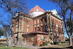
Clay County Courthouse in Henrietta
|
|

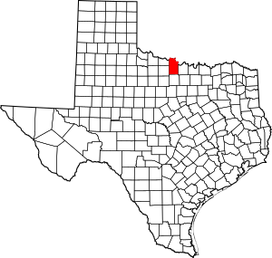
Location within the U.S. state of Texas
|
|
 Texas's location within the U.S. |
|
| Country | |
| State | |
| Founded | 1860 |
| Named for | Henry Clay |
| Seat | Henrietta |
| Largest city | Henrietta |
| Area | |
| • Total | 1,117 sq mi (2,890 km2) |
| • Land | 1,089 sq mi (2,820 km2) |
| • Water | 28 sq mi (70 km2) 2.5% |
| Population
(2020)
|
|
| • Total | 10,218 |
| • Density | 9/sq mi (3/km2) |
| Time zone | UTC−6 (Central) |
| • Summer (DST) | UTC−5 (CDT) |
| Congressional district | 13th |
Clay County is a county in the U.S. state of Texas. In 2020, about 10,218 people lived there. The main town, or county seat, is Henrietta. Clay County was started in 1857 and officially set up in 1860. It is named after Henry Clay, a famous American leader from Kentucky. He was a Senator and a United States Secretary of State. Clay County is also part of the larger Wichita Falls area in North Texas.
Contents
About Clay County
Clay County is known for its history and natural beauty. A rancher and oilman named Joseph Sterling Bridwell once owned a large ranch here. He was also a philanthropist, meaning he gave money to help others.
Geography and Nature
Clay County covers a total area of 1,117 square miles. Most of this area, 1,089 square miles, is land. The rest, 28 square miles, is water.
Lake Arrowhead State Park
One of the special places in Clay County is Lake Arrowhead State Park. This park covers 524 acres and is located on Lake Arrowhead. The lake itself is very large, covering 14,390 acres. Its shoreline stretches for 106 miles!
At Lake Arrowhead State Park, you can enjoy many outdoor activities. These include bicycling, watching birds, boating, camping, canoeing, and fishing. You can also go hiking, horseback riding, or simply study nature. It's a great spot for picnicking, swimming, and observing wildlife.
Neighboring Counties
Clay County shares its borders with several other counties:
- Jefferson County, Oklahoma (to the north)
- Montague County (to the east)
- Jack County (to the south)
- Archer County (to the west)
- Wichita County (to the northwest)
- Cotton County, Oklahoma (to the northwest)
People of Clay County
The number of people living in Clay County has changed over the years. Here's a look at the population from different census counts:
| Historical population | |||
|---|---|---|---|
| Census | Pop. | %± | |
| 1860 | 109 | — | |
| 1880 | 5,045 | — | |
| 1890 | 7,503 | 48.7% | |
| 1900 | 9,231 | 23.0% | |
| 1910 | 17,043 | 84.6% | |
| 1920 | 16,864 | −1.1% | |
| 1930 | 14,545 | −13.8% | |
| 1940 | 12,524 | −13.9% | |
| 1950 | 9,896 | −21.0% | |
| 1960 | 8,351 | −15.6% | |
| 1970 | 8,079 | −3.3% | |
| 1980 | 9,582 | 18.6% | |
| 1990 | 10,024 | 4.6% | |
| 2000 | 11,006 | 9.8% | |
| 2010 | 10,752 | −2.3% | |
| 2020 | 10,218 | −5.0% | |
| U.S. Decennial Census 1850–2010 2010 2020 |
|||
In 2000, there were 11,006 people living in Clay County. The population density was about 10 people per square mile. Most people in the county were White (95.35%). A smaller number were Black or African American (0.42%), Native American (1.03%), or Asian (0.10%). About 3.67% of the population was Hispanic or Latino.
The average age in the county in 2000 was 40 years old. About 24.90% of the people were under 18 years old.
Getting Around Clay County
Several important roads help people travel through Clay County.
Main Highways
Farm to Market Roads
These roads connect rural areas to larger towns.
Towns and Communities
Clay County has several towns and communities where people live.
Cities
- Bellevue
- Byers
- Dean
- Henrietta (This is the county seat, the main town for county government.)
- Jolly
- Petrolia
Town
- Windthorst (Most of this town is in Archer County.)
Small Communities
- Bluegrove
- Buffalo Springs
- Charlie
- Hurnville
- Joy
- Newport (Also partly in Jack County.)
- Shannon
- Stanfield
- Thornberry
- Vashti
Ghost Towns
These are places where towns used to be, but now very few or no people live there.
- Deer Creek
- Halsell
- Prospect
- Raymond
Education in Clay County
Students in Clay County attend schools in various school districts:
- Bellevue Independent School District
- Bowie Independent School District
- Burkburnett Independent School District
- Gold-Burg Independent School District
- Henrietta Independent School District
- Midway Independent School District
- Petrolia Consolidated Independent School District
- Windthorst Independent School District
For college, the county is served by Vernon College.
See also
 In Spanish: Condado de Clay (Texas) para niños
 | Precious Adams |
 | Lauren Anderson |
 | Janet Collins |


