Wichita County, Texas facts for kids
Quick facts for kids
Wichita County
|
|
|---|---|

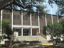
The Wichita County Courthouse in downtown Wichita Falls
|
|

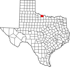
Location within the U.S. state of Texas
|
|
 Texas's location within the U.S. |
|
| Country | |
| State | |
| Founded | February 1, 1882 |
| Seat | Wichita Falls |
| Largest city | Wichita Falls |
| Area | |
| • Total | 633 sq mi (1,640 km2) |
| • Land | 628 sq mi (1,630 km2) |
| • Water | 5.3 sq mi (14 km2) 0.8% |
| Population
(2020)
|
|
| • Total | 129,350 |
| • Estimate
(2022)
|
129,978 |
| • Density | 204.34/sq mi (78.90/km2) |
| Time zone | UTC−6 (Central) |
| • Summer (DST) | UTC−5 (CDT) |
| Congressional district | 13th |
Wichita County is a place in the state of Texas, United States. In 2020, about 129,350 people lived there. The main city, where the county government is located, is Wichita Falls. The county was officially started in 1858 and began working in 1882. Wichita County is part of the larger Wichita Falls area.
Contents
Exploring Wichita County's Geography
Wichita County covers a total area of about 633 square miles. Most of this area is land, with only a small part (about 5.3 square miles) covered by water. The Wichita River and other smaller streams flow through the county.
Main Roads in Wichita County
Many important roads help people travel through Wichita County. These include major highways that connect the county to other parts of Texas and nearby states.
Neighboring Counties
Wichita County shares its borders with several other counties. Some are in Texas, and others are in the nearby state of Oklahoma.
- Tillman County, Oklahoma (north)
- Cotton County, Oklahoma (northeast)
- Clay County (east)
- Archer County (south)
- Wilbarger County (west)
- Baylor County (southwest)
Discovering Wichita County's Geology
Wichita County is part of an area known as the Texas Red Beds. These are layers of red-colored rock that formed a very long time ago, during the Early Permian period.
Scientists first found fossils of ancient animals from the Permian period here in 1877. Since then, they have discovered rare fossils of amphibians, which are animals that can live both in water and on land. They have also found many fossils of other four-legged animals from that time, like the Dimetrodon and Diadectes.
Understanding Wichita County's Population
The number of people living in Wichita County has changed over the years. Here's a quick look at how the population has grown:
| Historical population | |||
|---|---|---|---|
| Census | Pop. | %± | |
| 1880 | 433 | — | |
| 1890 | 4,831 | 1,015.7% | |
| 1900 | 5,806 | 20.2% | |
| 1910 | 16,094 | 177.2% | |
| 1920 | 72,911 | 353.0% | |
| 1930 | 74,416 | 2.1% | |
| 1940 | 73,604 | −1.1% | |
| 1950 | 98,493 | 33.8% | |
| 1960 | 123,528 | 25.4% | |
| 1970 | 120,563 | −2.4% | |
| 1980 | 121,082 | 0.4% | |
| 1990 | 122,378 | 1.1% | |
| 2000 | 131,664 | 7.6% | |
| 2010 | 131,500 | −0.1% | |
| 2020 | 129,350 | −1.6% | |
| 2022 (est.) | 129,978 | −1.2% | |
| U.S. Decennial Census 1850–2010 2010-2020 |
|||
In 2000, about 131,664 people lived in the county. The population density was about 210 people per square mile. This means that, on average, 210 people lived in an area the size of one square mile.
The average household in Wichita County had about 2.49 people. The average family had about 3.04 people. About 25.2% of the people in the county were under 18 years old. The median age, which is the middle age of all the people, was 33 years old.
The average income for a household in the county was $33,780. For families, it was $40,937. About 13.2% of the people in Wichita County lived below the poverty line. This included 17.4% of those under 18 and 9.8% of those 65 or older.
Communities in Wichita County
Wichita County has several towns and cities where people live.
Cities
- Cashion Community
- Burkburnett
- Electra
- Iowa Park
- Wichita Falls (This is the county seat, where the main government offices are.)
Town
Unincorporated Communities
These are smaller areas that are not officially part of a city or town.
Education in Wichita County
Several school districts serve the students in Wichita County. These districts manage the public schools in different areas.
- Burkburnett Independent School District
- City View Independent School District
- Electra Independent School District
- Holliday Independent School District
- Iowa Park Consolidated Independent School District
- Wichita Falls Independent School District
For students who want to continue their education after high school, Vernon College also serves this area.
See also
 In Spanish: Condado de Wichita (Texas) para niños
 | Frances Mary Albrier |
 | Whitney Young |
 | Muhammad Ali |

