
Henrietta, Texas facts for kids
Quick facts for kids
Henrietta
|
|
|---|---|

|
|

Location of Henrietta, Texas
|
|
 |
|
| Country | United States |
| State | Texas |
| County | Clay |
| Area | |
| • Total | 5.21 sq mi (13.49 km2) |
| • Land | 5.11 sq mi (13.22 km2) |
| • Water | 0.10 sq mi (0.26 km2) |
| Elevation | 915 ft (279 m) |
| Population
(2020)
|
|
| • Total | 3,111 |
| • Density | 609.40/sq mi (235.29/km2) |
| Time zone | UTC-6 (Central (CST)) |
| • Summer (DST) | UTC-5 (CDT) |
| ZIP code |
76365
|
| Area code(s) | 940 |
| FIPS code | 48-33284 |
| GNIS feature ID | 2410743 |
Henrietta is a city in Texas, United States. It is the main town, also known as the county seat, of Clay County. Henrietta is part of the larger Wichita Falls area. In 2020, about 3,111 people lived there. This was a small decrease from the 3,141 people counted in 2010.
Contents
History of Henrietta
Henrietta is one of the oldest towns in north central Texas. It is located where several important roads meet. These include U.S. Highway 287, U.S. Highway 82, State Highway 148, and Farm to Market Road 1197.
Clay and Montague counties were created in 1857. They were separated from Cooke County. Henrietta was chosen as the county seat, which is the main town for the county government. No one is quite sure how Henrietta got its name.
In 1860, Henrietta was the only town in Clay County. It had 109 residents, 10 houses, and a general store. It was on the far western edge of where Anglo settlers were moving in north-central Texas. However, Native Americans still lived in the area and were a threat to new settlers.
In 1862, Henrietta opened its post office. During the early 1860s, there were many attacks from local tribes. By late 1862, Henrietta was left empty. White settlers moved back east to Cooke and Montague counties. The buildings that were left were burned.
Settlers tried to return to Henrietta again. In 1865, after the Civil War, a group trying to resettle was attacked and killed. Some Quakers also tried to move back to the old town site. But its members were either killed or had to leave. In 1870, fifty soldiers and Kiowa Indians fought a battle in the ruins of Henrietta.
After this battle, white settlers returned to Henrietta for good. In 1874, the post office reopened. Henrietta quickly became an important center for business in north-central Texas. In 1882, the Fort Worth and Denver Railway reached Henrietta. In 1887, the Gainesville, Henrietta, and Western Railway also arrived.
In 1895, the Wichita Falls Railway connected Henrietta with Wichita Falls. This railway was later sold and operated by the Missouri-Kansas-Texas Railroad, also known as the Katy. This part of the track was removed in 1970.
Henrietta became a supply point for different businesses in north-central Texas. This included mining in Foard and Archer counties. In 1910, the Southwestern Railway Company built a rail line connecting Henrietta with Archer City.
Even though it was settled earlier, Henrietta officially became a city in 1881. The Clay County courthouse was built in 1884 and is still used today. By 1890, the city had grown to 2,100 people. It had a large opera house with 400 seats, five churches, a new jail, and a school. From 1893 to 1895, it even had a college called Henrietta Normal College. This college trained teachers. Henrietta remained the main business center of the county around 1900.
The St. Elmo Hotel was built around 1895 in Henrietta. Famous guests stayed there, including Quanah Parker, a Comanche leader, and U.S. President Theodore Roosevelt. When the top floors of the hotel burned, it closed and never reopened. Part of the first floor now holds an antiques shop.
Henrietta's growth slowed down in the 1900s. This happened as Wichita Falls grew much faster and became the main economic center in the area. The Southwestern Railway line was closed in 1920. The Gainesville, Henrietta, and Western Railway line closed in 1969. By 1990, the population was still under 3,000 people. In 2000, it reached over 3,000 for the first time since 1970. Today, Henrietta is often seen as a "bedroom community" for Wichita Falls. This means many people who live in Henrietta work in Wichita Falls. But Henrietta is still the largest city in Clay County.
The play Texas, performed in the summers near Amarillo, is based on Henrietta's history. The 1995 movie, The Stars Fell on Henrietta, was produced by Clint Eastwood. It stars Robert Duvall and shows the Texas oil boom of the 1930s. The movie is set in Henrietta.
Geography
Henrietta is located near the center of Clay County. It is about 20 miles southeast of Wichita Falls. It is also 28 miles northwest of Bowie and 95 miles northwest of Fort Worth.
The city has a total area of about 13.5 square kilometers (5.21 square miles). Most of this area is land, about 13.2 square kilometers (5.11 square miles). A small part, about 0.3 square kilometers (0.10 square miles), is water.
Population Information
| Historical population | |||
|---|---|---|---|
| Census | Pop. | %± | |
| 1890 | 2,100 | — | |
| 1900 | 1,614 | −23.1% | |
| 1910 | 2,104 | 30.4% | |
| 1920 | 2,563 | 21.8% | |
| 1930 | 2,020 | −21.2% | |
| 1940 | 2,391 | 18.4% | |
| 1950 | 2,813 | 17.6% | |
| 1960 | 3,062 | 8.9% | |
| 1970 | 2,897 | −5.4% | |
| 1980 | 3,149 | 8.7% | |
| 1990 | 2,896 | −8.0% | |
| 2000 | 3,264 | 12.7% | |
| 2010 | 3,141 | −3.8% | |
| 2020 | 3,111 | −1.0% | |
| U.S. Decennial Census | |||
| Race | Number | Percentage |
|---|---|---|
| White (NH) | 2,727 | 87.66% |
| Black or African American (NH) | 21 | 0.68% |
| Native American or Alaska Native (NH) | 24 | 0.77% |
| Asian (NH) | 29 | 0.93% |
| Some Other Race (NH) | 13 | 0.42% |
| Mixed/Multi-Racial (NH) | 131 | 4.21% |
| Hispanic or Latino | 166 | 5.34% |
| Total | 3,111 |
As of the 2020 United States census, there were 3,111 people living in Henrietta. There were 1,287 households and 817 families in the city.
Education
The city of Henrietta is served by the Henrietta Independent School District. South of town, between Henrietta and Jacksboro, students attend Midway Independent School District.
Transportation
Henrietta is connected by several important roads:
 U.S. Highway 287 goes west to Wichita Falls and east-southeast to Fort Worth.
 U.S. Highway 82 goes west to Lubbock and east to Nocona.
 State Highway 148 goes south to Jacksboro and north to Petrolia.
 Farm to Market Road 1197 goes north to Hurnville.
 Farm to Market Road 2847 goes southwest to FM 2606, Lake Arrowhead, and Halsell.
Climate
The weather in Henrietta has hot, humid summers. Winters are usually mild to cool. This type of weather is called a humid subtropical climate.
Notable People
Some well-known people have connections to Henrietta:
- Charline Arthur (1929–1987), a musician who played boogie woogie and blues.
- Finis Alonzo Crutchfield Jr. (1916–1986), a United Methodist Church bishop, was born in Henrietta.
- Frank N. Ikard, a congressman from Texas from 1951 to 1961, was born in Henrietta in 1914.
Images for kids
-
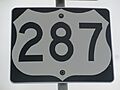
U.S. Route 287 has long been a key traffic artery in Henrietta.
-
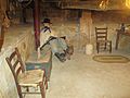
Sleeping guard exhibit at Clay County 1890 Jail Museum
-
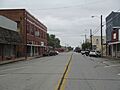
A portion of Henrietta
-
The First Baptist Church at 208 S. Graham Street in Henrietta was originally established in 1876. In 2013, the church had more than 1,300 members.
-
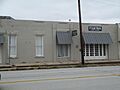
An antiques shop occupies part of the building which once housed the St. Elmo Hotel, long ago destroyed in a fire.
-
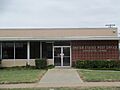
The U.S. Post Office is located in the southeastern corner of Courthouse Square in Henrietta.


See also
 In Spanish: Henrietta (Texas) para niños
