
Bowie, Texas facts for kids
Quick facts for kids
Bowie
|
|
|---|---|
.jpg)
Downtown Bowie, Texas
|
|
| Country | United States |
| State | Texas |
| County | Montague |
| Government | |
| • Type | Council-Manager |
| Area | |
| • Total | 5.54 sq mi (14.36 km2) |
| • Land | 5.52 sq mi (14.29 km2) |
| • Water | 0.02 sq mi (0.06 km2) |
| Elevation | 1,116 ft (340 m) |
| Population
(2020)
|
|
| • Total | 5,448 |
| • Estimate
(2021)
|
5,534 |
| • Density | 983.4/sq mi (379.39/km2) |
| Time zone | UTC-6 (Central (CST)) |
| • Summer (DST) | UTC-5 (CDT) |
| ZIP code |
76230
|
| Area code(s) | 940 |
| FIPS code | 48-09640 |
| GNIS feature ID | 2409888 |
Bowie (pronounced BOO-ee) is a city located in Montague County, Texas, in the United States. In 2020, about 5,448 people lived there.
Contents
History of Bowie, Texas
Bowie officially became a town on July 22, 1881. It is in Montague County, Texas. There is also a Bowie County in Texas, but that's a different place!
The town grew quickly when the Fort Worth and Denver Railway arrived in 1882. This made it easier for people and goods to travel.
In 1884, a group of four men robbed the First National Bank of Bowie. They took more than $10,000 in gold coins. The people of the town chased after them and caught the robbers. The robbers were then punished for their crimes.
By 1913, Bowie had grown to more than 5,000 people. It even had a school called the Bowie Commercial College.
A famous visitor, U.S. President Franklin D. Roosevelt, came to Bowie on his train on July 11, 1938. He playfully bought biscuits from a businessman named Amon G. Carter. Mr. Carter had grown up in Bowie.
Later, in 1941, another person named Rex Beard, Jr., robbed the First National Bank of Bowie. He was caught in December of the same year.
Geography and Roads
Bowie covers a total area of about 5.52 square miles (14.29 square kilometers). Most of this area is land.
Main Roads in Bowie
Several important roads pass through Bowie, making it easy to travel to and from the city:
- U.S. Route 81
- U.S. Route 287
- Texas State Highway 59
People Living in Bowie
The number of people living in Bowie has changed over the years. Here's how the population has grown:
| Historical population | |||
|---|---|---|---|
| Census | Pop. | %± | |
| 1890 | 1,486 | — | |
| 1900 | 2,600 | 75.0% | |
| 1910 | 2,874 | 10.5% | |
| 1920 | 3,179 | 10.6% | |
| 1930 | 3,131 | −1.5% | |
| 1940 | 3,470 | 10.8% | |
| 1950 | 4,544 | 31.0% | |
| 1960 | 4,566 | 0.5% | |
| 1970 | 5,185 | 13.6% | |
| 1980 | 5,610 | 8.2% | |
| 1990 | 4,990 | −11.1% | |
| 2000 | 5,219 | 4.6% | |
| 2010 | 5,218 | 0.0% | |
| 2020 | 5,448 | 4.4% | |
| 2021 (est.) | 5,534 | 6.1% | |
| U.S. Decennial Census | |||
Bowie's Population in 2020
The 2020 United States census counted 5,448 people living in Bowie. There were 1,911 households and 1,333 families.
Here's a look at the different groups of people living in Bowie in 2020:
| Group | Number of People | Percentage of Total |
|---|---|---|
| White (NH) | 4,177 | 76.67% |
| Black or African American (NH) | 33 | 0.61% |
| Native American or Alaska Native (NH) | 44 | 0.81% |
| Asian (NH) | 36 | 0.66% |
| Pacific Islander (NH) | 2 | 0.04% |
| Some other group (NH) | 7 | 0.13% |
| Mixed/multiracial (NH) | 275 | 5.05% |
| Hispanic or Latino | 874 | 16.04% |
| Total | 5,448 |
Bowie's Population in 2010
In 2010, the census showed that 5,218 people lived in Bowie. There were 2,090 households and 2,489 housing units.
The population density was about 945.6 people per square mile. This means that, on average, about 945 people lived in each square mile of the city.
The average household had 2.32 people, and the average family had 2.99 people.
The money earned by households in Bowie was about $33,846 per year (median income). The per capita income (money earned per person) was $19,063.
Education in Bowie
Students in Bowie attend schools that are part of the Bowie Independent School District. There is also a local college branch, North Central Texas College, for higher education.
Famous People from Bowie
Some well-known people have connections to Bowie:
- James V. Allred: He was the 33rd Governor of Texas.
- Amon Carter: A famous businessman who created and published the Fort Worth Star-Telegram newspaper.
- Woodrow Chambliss: An actor.
Gallery
-
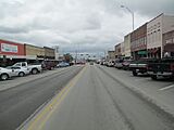
A look at downtown Bowie (2013)
-
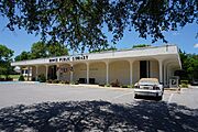
Bowie Public Library
-
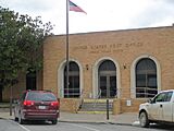
U.S. Post Office in Bowie
-
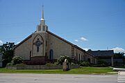
St. Peter Lutheran Church at 906 Highway 59 North in Bowie; pastor Larry Knobloch (2013)

.jpg)

.jpg)
See also
 In Spanish: Bowie (Texas) para niños
