
Jefferson County, Oklahoma facts for kids
Quick facts for kids
Jefferson County
|
|
|---|---|

Jefferson County Courthouse in Waurika (2014)
|
|

Location within the U.S. state of Oklahoma
|
|
 Oklahoma's location within the U.S. |
|
| Country | |
| State | |
| Founded | 1907 |
| Named for | Thomas Jefferson |
| Seat | Waurika |
| Largest city | Waurika |
| Area | |
| • Total | 774 sq mi (2,000 km2) |
| • Land | 759 sq mi (1,970 km2) |
| • Water | 15 sq mi (40 km2) 2.0%% |
| Population
(2020)
|
|
| • Total | 5,337 |
| • Density | 6.9/sq mi (2.7/km2) |
| Time zone | UTC−6 (Central) |
| • Summer (DST) | UTC−5 (CDT) |
| Congressional district | 4th |
Jefferson County is a county in the state of Oklahoma. In 2020, about 5,337 people lived there. The main town, or county seat, is Waurika. The county was created in 1907 when Oklahoma became a state. It was named after Thomas Jefferson, who was a President of the United States.
Contents
History of Jefferson County
Early Native American Life
In the 1750s, the Taovaya Indians, a group from the Wichita tribe, built two villages. These villages were along the Red River. One was in what is now Jefferson County, and the other was across the river in Texas.
These villages became a busy trading place. Comanches would bring things like horses and mules to trade. They exchanged them for French goods like powder, knives, and cloth. The Taovaya also grew and traded crops like corn, melons, and pumpkins.
In 1759, the Spanish army attacked these villages. This was after the Taovaya and their friends destroyed a Spanish mission. But the Native American tribes won, defeating the Spanish army. This event is known as the Battle of the Twin Villages.
By 1841, the Taovaya villages were empty. Many Taovaya people had died from smallpox. Also, other Native American tribes and American settlers moved into their lands.
Tribal Lands and New Settlements
In the 1830s, the Choctaw tribe gained control of most of the land that is now Jefferson County. The Chickasaw tribe, who were related to the Choctaw, also started to move into the area. In 1855, the two tribes officially divided their lands. This area then became part of the Chickasaw Nation.
Later, the western part of the county became a reservation for the Kiowa, Comanche, and Apache tribes. This happened because of the 1867 Medicine Lodge Treaty. In 1901, this land was opened up for non-Native American settlers.
Cattle Trails and Railroads
After the American Civil War, the Chisholm Trail became very important. This trail passed through Jefferson County. It was used to move large groups of cattle from Texas to markets in Kansas.
Later, railroads were built along these old trails. In 1892, the Chicago, Rock Island and Pacific Railway laid tracks here. More lines were built, connecting towns like Lawton and Waurika. The last railroad in the county was built in 1923, but it closed in 1942.
Oklahoma Statehood
Before Oklahoma became a state, this area was part of the Pickens County, Chickasaw Nation.
When Oklahoma became a state in 1907, the Chickasaw government ended. This is when Jefferson County was officially created. At first, the town of Ryan was chosen as the county seat. But in 1908, there was an election between Ryan, Sugden, and Waurika. No town won enough votes. Another election was held in 1912, and this time, Waurika was chosen as the county seat.
Geography of Jefferson County
Jefferson County covers about 774 square miles. Most of this is land (759 square miles), and a small part is water (15 square miles). The county's rivers and streams flow into the Red River. Two important creeks are Beaver Creek and Mud Creek.
Waurika Lake was created in 1971. It was made by building a dam on Beaver Creek in the northwestern part of the county.
Main Roads
- U.S. Highway 70
- U.S. Highway 81
- State Highway 5
- State Highway 32
- State Highway 79
- State Highway 89


Neighboring Counties
- Stephens County (north)
- Carter County (northeast)
- Love County (east)
- Montague County, Texas (south)
- Clay County, Texas (southwest)
- Cotton County (west)
Population Changes
| Historical population | |||
|---|---|---|---|
| Census | Pop. | %± | |
| 1910 | 17,430 | — | |
| 1920 | 17,664 | 1.3% | |
| 1930 | 17,392 | −1.5% | |
| 1940 | 15,107 | −13.1% | |
| 1950 | 11,122 | −26.4% | |
| 1960 | 8,192 | −26.3% | |
| 1970 | 7,125 | −13.0% | |
| 1980 | 8,183 | 14.8% | |
| 1990 | 7,010 | −14.3% | |
| 2000 | 6,818 | −2.7% | |
| 2010 | 6,472 | −5.1% | |
| 2020 | 5,337 | −17.5% | |
| U.S. Decennial Census 1790-1960 1900-1990 1990-2000 2010-2019 |
|||
In 2000, there were 6,818 people living in Jefferson County. About 87% of the people were White, and about 5% were Native American. About 7% of the population was of Hispanic or Latino background.
The average age of people in the county in 2000 was 40 years old. About 24% of the population was under 18 years old.
Towns and Communities
Cities
- Waurika (This is the county seat, the main town for county government.)
Towns
Small Communities (Unincorporated)
These are smaller places that are not officially towns or cities.
Images for kids
-
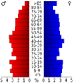
Age pyramid for Jefferson County, Oklahoma, based on census 2000 data.

See also
 In Spanish: Condado de Jefferson (Oklahoma) para niños
