Carter County, Oklahoma facts for kids
Quick facts for kids
Carter County
|
|
|---|---|

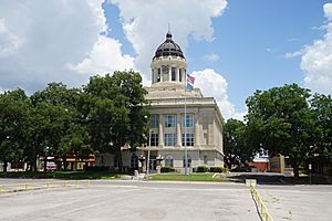
Carter County Courthouse in Ardmore
|
|

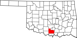
Location within the U.S. state of Oklahoma
|
|
 Oklahoma's location within the U.S. |
|
| Country | |
| State | |
| Founded | 1907 |
| Named for | Ben W. Carter |
| Seat | Ardmore |
| Largest city | Ardmore |
| Area | |
| • Total | 834 sq mi (2,160 km2) |
| • Land | 822 sq mi (2,130 km2) |
| • Water | 12 sq mi (30 km2) 1.4%% |
| Population
(2020)
|
|
| • Total | 48,003 |
| • Density | 58/sq mi (22/km2) |
| Time zone | UTC−6 (Central) |
| • Summer (DST) | UTC−5 (CDT) |
| Congressional district | 4th |
Carter County is a county in the state of Oklahoma, USA. In 2020, about 48,003 people lived there. The main city and county seat is Ardmore.
The county is named after Captain Ben W. Carter. He was a Cherokee person who lived with the Chickasaw people. Carter County is also part of the Ardmore Micropolitan Statistical Area. It is also part of the Texoma region.
Contents
History of Carter County
Before Oklahoma became a state, the area that is now Carter County was part of Pickens County. This was in the Chickasaw Nation of the Indian Territory.
Railroads and Oil
After the Civil War, the U.S. government made the Chickasaw government allow railroads to be built. The Gulf, Colorado and Santa Fe Railway built a line north from Texas.
Later, the Arkansas and Choctaw Railway built a line to Ardmore. Oil production in the area led to even more railroads being built. Some of these older rail lines were stopped in 1976.
Oil and gas production started early in the 1900s. The Healdton oil field opened in 1913. This helped Ardmore become a major center for oil production.
Ardmore's Growth and Industry
In 1915, a big fire happened in Ardmore when a train car exploded. This sad event killed 43 people and destroyed much of the downtown area.
However, Ardmore and the local oil industry recovered. The city also became a place for manufacturing. Companies like Akron Tire and Rubber Company built factories there. Later, Uniroyal and Michelin North America also had tire plants in Ardmore. By the early 2000s, manufacturing was the biggest part of the county's economy.
Geography of Carter County
According to the U.S. Census Bureau, Carter County covers about 834 square miles. Most of this is land (822 square miles), and a small part is water (12 square miles).
Land and Water
The county has different types of land. These include parts of the Arbuckle Mountains and flat plains. The northern part of the county drains into the Washita River. Several smaller streams in the southern part flow directly into the Red River.
Oil Geology
The Healdton Field is an important oil area in Carter County. It produces oil from different rock layers deep underground. This area has a special underground shape called an "anticline." It is like a long, raised fold in the rocks.
Oil was first found here in the 1890s, but laws stopped drilling on "Indian lands" for a while. The official discovery of the Healdton oil field is credited to a well drilled in 1913.
Major Highways
Adjacent Counties
Carter County shares borders with these other counties:
- Garvin County (north)
- Murray County (northeast)
- Johnston County (east)
- Marshall County (southeast)
- Love County (south)
- Jefferson County (southwest)
- Stephens County (northwest)
People of Carter County (Demographics)
| Historical population | |||
|---|---|---|---|
| Census | Pop. | %± | |
| 1910 | 25,358 | — | |
| 1920 | 40,247 | 58.7% | |
| 1930 | 41,419 | 2.9% | |
| 1940 | 43,292 | 4.5% | |
| 1950 | 36,455 | −15.8% | |
| 1960 | 39,044 | 7.1% | |
| 1970 | 37,349 | −4.3% | |
| 1980 | 43,610 | 16.8% | |
| 1990 | 42,919 | −1.6% | |
| 2000 | 45,621 | 6.3% | |
| 2010 | 47,557 | 4.2% | |
| 2020 | 48,003 | 0.9% | |
| U.S. Decennial Census 1790-1960 1900-1990 1990-2000 2010 |
|||
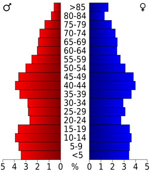
In 2000, there were 45,621 people living in Carter County. About 18,000 households were counted. The population density was about 55 people per square mile.
Most people in the county were White (77.4%). There were also significant numbers of Black or African American people (7.60%) and Native American people (7.92%). About 2.78% of the population was Hispanic or Latino. By 2020, the population had grown to 48,003 people.
In 2000, about 32.50% of households had children under 18 living with them. The average household had 2.47 people. The median age in the county was 38 years old.
In 2000, the median income for a household was $29,405 per year. For families, it was $36,729. About 16.60% of the population lived below the poverty line. By 2021, the median household income had risen to $52,906. The poverty rate was about 14.2%.
Communities in Carter County
Cities
- Ardmore (county seat)
- Healdton
- Lone Grove
- Wilson
Towns
Unincorporated Communities
These are smaller places that are not officially cities or towns:
See also
 In Spanish: Condado de Carter (Oklahoma) para niños
 | George Robert Carruthers |
 | Patricia Bath |
 | Jan Ernst Matzeliger |
 | Alexander Miles |


