Wilson, Oklahoma facts for kids
Quick facts for kids
Wilson, Oklahoma
|
|
|---|---|

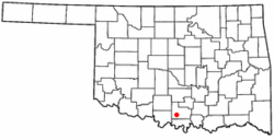
Location of Wilson, Oklahoma
|
|
| Country | United States |
| State | Oklahoma |
| County | Carter |
| Area | |
| • Total | 5.66 sq mi (14.65 km2) |
| • Land | 5.64 sq mi (14.62 km2) |
| • Water | 0.01 sq mi (0.03 km2) |
| Elevation | 909 ft (277 m) |
| Population
(2020)
|
|
| • Total | 1,399 |
| • Density | 247.87/sq mi (95.71/km2) |
| Time zone | UTC-6 (Central (CST)) |
| • Summer (DST) | UTC-5 (CDT) |
| ZIP code |
73463
|
| Area code(s) | 580 |
| FIPS code | 40-81500 |
| GNIS feature ID | 2412275 |
Wilson is a small town located in Carter County, Oklahoma, in the United States. In 2010, about 1,724 people lived there. Wilson is part of the larger Ardmore area. It is also known for having one of Oklahoma's oldest Assemblies of God churches.
Contents
History of Wilson
The town of Wilson has an interesting past. In 1913, John Ringling, famous for the Ringling Brothers Circus, built a railway line. This line went west from Ardmore to the place where Wilson would later be.
Ringling himself chose the name for the new settlement. It was first called "New Wilson." This was to honor Charles Wilson, who was the manager of the Ringling Brothers Circus. A post office opened in the town on January 17, 1914. The town officially became a city in the same year. Later, in 1918, its name was shortened to just Wilson.
Geography of Wilson
Wilson is found in the southwestern part of Carter County. U.S. Highway 70 goes through the town, just north of the main populated area.
This highway connects Wilson to other places. If you go east on Highway 70, you will reach Ardmore in about 16 miles (26 km). Ardmore is the main city of Carter County. If you travel west for about 35 miles (56 km), you will arrive in Waurika.
According to the United States Census Bureau, Wilson covers a total area of about 5.7 square miles (14.7 km2). A very small part of this area, about 0.01 square miles (0.03 km2), is water.
Population and People
| Historical population | |||
|---|---|---|---|
| Census | Pop. | %± | |
| 1920 | 2,286 | — | |
| 1930 | 2,517 | 10.1% | |
| 1940 | 1,700 | −32.5% | |
| 1950 | 1,832 | 7.8% | |
| 1960 | 1,647 | −10.1% | |
| 1970 | 1,569 | −4.7% | |
| 1980 | 1,585 | 1.0% | |
| 1990 | 1,639 | 3.4% | |
| 2000 | 1,584 | −3.4% | |
| 2010 | 1,724 | 8.8% | |
| 2020 | 1,399 | −18.9% | |
| U.S. Decennial Census | |||
In the year 2000, there were 1,584 people living in Wilson. These people lived in 625 households, and 426 of these were families. The town had about 278 people per square mile (107 per km2). There were 785 homes in total.
Most of the people in Wilson were White (about 89.7%). About 6.6% were Native American. A small number of people were from other backgrounds. About 1.8% of the population was Hispanic or Latino.
Age Groups
The population in Wilson was spread out across different age groups.
- About 26.5% of the people were under 18 years old.
- About 7.8% were between 18 and 24 years old.
- About 23.9% were between 25 and 44 years old.
- About 21.5% were between 45 and 64 years old.
- About 20.2% were 65 years old or older.
The average age of people in Wilson was 38 years. For every 100 females, there were about 89 males.
Historic Places
Just north of Wilson, there is a special building called the Healdton Oil Field Bunkhouse. This building is listed on the National Register of Historic Places. This means it is an important historical site that is protected.
See also
 In Spanish: Wilson (Oklahoma) para niños
 | Audre Lorde |
 | John Berry Meachum |
 | Ferdinand Lee Barnett |

