Carter, Oklahoma facts for kids
Quick facts for kids
Carter, Oklahoma
|
|
|---|---|

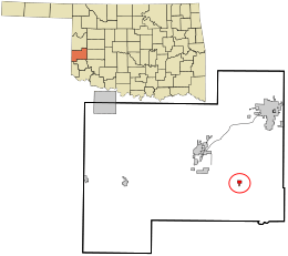
Location in Beckham County and the state of Oklahoma
|
|
| Country | United States |
| State | Oklahoma |
| County | Beckham |
| Area | |
| • Total | 0.53 sq mi (1.38 km2) |
| • Land | 0.53 sq mi (1.38 km2) |
| • Water | 0.00 sq mi (0.00 km2) |
| Elevation | 1,828 ft (557 m) |
| Population
(2020)
|
|
| • Total | 183 |
| • Density | 343.98/sq mi (132.86/km2) |
| Time zone | UTC-6 (Central (CST)) |
| • Summer (DST) | UTC-5 (CDT) |
| ZIP code |
73627
|
| Area code(s) | 580 |
| FIPS code | 40-12300 |
| GNIS feature ID | 2413175 |
Carter is a small town located in Beckham County, Oklahoma, in the United States. It's a quiet place where people live and work. According to the 2020 census, 183 people called Carter home.
Geography of Carter
Carter is a small town, covering about 0.5 square miles (1.38 square kilometers) of land. It doesn't have any large lakes or rivers within its borders.
You can find Carter where two main roads meet: State Highway 34 and State Highway 55. Highway 55 actually starts right here in Carter!
Carter's Climate
The weather in Carter, Oklahoma, changes throughout the year. Summers are usually hot, and winters are cool. The town gets some rain, especially in spring and early summer.
| Climate data for Carter, Oklahoma | |||||||||||||
|---|---|---|---|---|---|---|---|---|---|---|---|---|---|
| Month | Jan | Feb | Mar | Apr | May | Jun | Jul | Aug | Sep | Oct | Nov | Dec | Year |
| Mean daily maximum °F (°C) | 49.6 (9.8) |
54.9 (12.7) |
64.9 (18.3) |
74.8 (23.8) |
82.7 (28.2) |
90.6 (32.6) |
96.9 (36.1) |
95.3 (35.2) |
86.5 (30.3) |
75.8 (24.3) |
61.8 (16.6) |
51.4 (10.8) |
73.8 (23.2) |
| Mean daily minimum °F (°C) | 22.7 (−5.2) |
27.5 (−2.5) |
35.9 (2.2) |
46.0 (7.8) |
55.1 (12.8) |
64.1 (17.8) |
68.6 (20.3) |
66.9 (19.4) |
59.4 (15.2) |
47.6 (8.7) |
35.5 (1.9) |
25.9 (−3.4) |
46.3 (7.9) |
| Average precipitation inches (mm) | 0.5 (13) |
0.8 (20) |
1.5 (38) |
1.9 (48) |
4.3 (110) |
3.7 (94) |
1.7 (43) |
2.4 (61) |
3.0 (76) |
2.2 (56) |
1.4 (36) |
0.6 (15) |
24 (610) |
| Source 1: weather.com | |||||||||||||
| Source 2: Weatherbase.com | |||||||||||||
People of Carter
The number of people living in Carter has changed over the years. Here's a look at the population from 1910 to 2020:
| Historical population | |||
|---|---|---|---|
| Census | Pop. | %± | |
| 1910 | 265 | — | |
| 1920 | 389 | 46.8% | |
| 1930 | 642 | 65.0% | |
| 1940 | 535 | −16.7% | |
| 1950 | 406 | −24.1% | |
| 1960 | 364 | −10.3% | |
| 1970 | 311 | −14.6% | |
| 1980 | 367 | 18.0% | |
| 1990 | 286 | −22.1% | |
| 2000 | 254 | −11.2% | |
| 2010 | 256 | 0.8% | |
| 2020 | 183 | −28.5% | |
| U.S. Decennial Census | |||
In 2000, there were 254 people living in Carter. Most people in Carter were White (about 85%). Some residents were Native American or from other backgrounds. About 11% of the population was Hispanic or Latino.
The town had 114 households. Many of these were married couples living together. About 26% of households had children under 18. The average age of people in Carter was 37 years old.
Education in Carter
Students in Carter attend schools in two different public school districts. Parts of the town are served by Merritt Public Schools, and other parts are served by Sentinel Public Schools.
See also
 In Spanish: Carter (Oklahoma) para niños
 | James B. Knighten |
 | Azellia White |
 | Willa Brown |

