
Marietta, Oklahoma facts for kids
Quick facts for kids
Marietta, Oklahoma
|
|
|---|---|
_(cropped).jpg)
Aerial view of Marietta
|
|
| Motto(s):
"Gateway To Lake Country"
|
|

Location of Marietta, Oklahoma
|
|
| Country | United States |
| State | Oklahoma |
| County | Love |
| Area | |
| • Total | 2.59 sq mi (6.71 km2) |
| • Land | 2.58 sq mi (6.69 km2) |
| • Water | 0.01 sq mi (0.02 km2) |
| Elevation | 837 ft (255 m) |
| Population
(2020)
|
|
| • Total | 2,719 |
| • Density | 1,053.06/sq mi (406.53/km2) |
| Time zone | UTC-6 (Central (CST)) |
| • Summer (DST) | UTC-5 (CDT) |
| ZIP code |
73448
|
| Area code(s) | 580 |
| FIPS code | 40-46500 |
| GNIS feature ID | 2411034 |
.jpg)
Marietta is a city in Love County, Oklahoma, United States. It is also the county seat, which means it's where the main government offices for the county are located.
In 2020, about 2,719 people lived in Marietta. This was a small increase from the 2,626 people counted in 2010. Marietta is part of the Ardmore, Oklahoma area. The Oklahoma Department of Tourism calls this area 'Chickasaw Country' for visitors. It is also part of the larger Texoma region, which is near the border of Texas and Oklahoma.
Contents
History of Marietta
Early Settlers and Farming
People were first drawn to the Marietta area because of its rich land. This land was close to the Red River. It was perfect for farming and raising cattle. Cotton quickly became the most important crop grown here.
A man named William "Bill" Washington had a very large cattle ranch. His brother, Jeremiah Calvin Washington (Jerry), lived nearby. Jerry became the town's first postmaster in 1887. He was also a banker and a rancher. Some local stories say the town was named after Jerry's wife, Marietta Love Washington.
Railroad and Growth
The Gulf, Colorado and Santa Fe Railway built its train tracks through the area in 1887. This helped Marietta grow a lot. The first train ran on July 28, 1887.
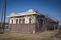
By 1907, when Oklahoma became a state, Marietta had 1,391 people. The Love County Courthouse was built in 1910. It was one of the first courthouses built in Oklahoma after it became a state. Today, it is listed on the National Register of Historic Places.
In 1910, Marietta had 1,546 residents. The town had at least three banks, three churches, and many shops.
Recent Events
On April 27, 2024, a very strong tornado hit the northwestern part of Marietta. Many buildings were badly damaged, including a large warehouse and a supermarket. Sadly, one person died on I-35 during the storm.
Geography
Marietta is located about 15 miles (24 km) north of the Red River. It is also about 114 miles (183 km) south of Oklahoma City.
The city covers a total area of about 2.4 square miles (6.2 km2). Most of this area is land, with a very small amount of water.
Population Information
| Historical population | |||
|---|---|---|---|
| Census | Pop. | %± | |
| 1900 | 842 | — | |
| 1910 | 1,546 | 83.6% | |
| 1920 | 1,977 | 27.9% | |
| 1930 | 1,505 | −23.9% | |
| 1940 | 1,837 | 22.1% | |
| 1950 | 1,875 | 2.1% | |
| 1960 | 1,933 | 3.1% | |
| 1970 | 2,013 | 4.1% | |
| 1980 | 2,494 | 23.9% | |
| 1990 | 2,306 | −7.5% | |
| 2000 | 2,445 | 6.0% | |
| 2010 | 2,626 | 7.4% | |
| 2020 | 2,719 | 3.5% | |
| U.S. Decennial Census | |||
In 2010, Marietta had 2,626 people living in 983 households. About 34% of these households had children under 18. The average household had 2.6 people.
The population was spread out by age. About 28.7% of the people were under 18. About 15.1% were 65 years or older. The average age in Marietta was 33.7 years.
Economy
Marietta's downtown area faced challenges when Interstate 35 was built nearby. This highway made it easier for people to bypass the downtown shops.
Around the year 2000, the main employers were the Marietta Bakery and Siemens Dematic. The bakery had about 400 workers, and Siemens had 65. In 2004, both companies closed.
Later, the Chickasaw Nation bought the Siemens plant. They hired many of the former workers again. This facility now builds and fixes equipment for oil fields. The Chickasaw Nation also bought the bakery and reopened it. However, it now has fewer workers than before.
Transportation
Highways
Marietta is located on State Highway 32. It is also at the corner of U.S. Route 77. Interstate 35 is just east of the city.
Airports
There are a few airports near Marietta.
- McGehee Catfish Restaurant Airport was located southwest of Marietta. It is now closed.
- Love County Airport was northwest of Marietta. It is also closed.
- Hankins Airport (1OK9) is a private airport north of Marietta.
- Faith Field Airport (OL27) is another private airport northeast of Marietta.
Notable residents
- Guilherme Marchi - He is a former professional bull rider. He won the PBR World Champion title in 2008. He is now an assistant coach for the Kansas City Outlaws PBR team.
Photo gallery
-
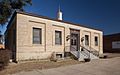
United States Post Office
-
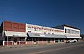
Downtown Marietta
-
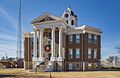
Love County Courthouse
-
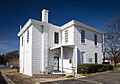
Old Love County Jail
-
Santa Fe Depot
.jpg)
.jpg)
.jpg)
.jpg)
.jpg)
See also
 In Spanish: Marietta (condado de Love, Oklahoma) para niños
