Union County, New Mexico facts for kids
Quick facts for kids
Union County
|
|
|---|---|

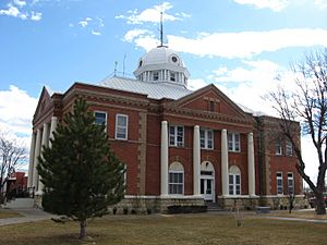
Union County Courthouse in Clayton
|
|

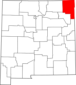
Location within the U.S. state of New Mexico
|
|
 New Mexico's location within the U.S. |
|
| Country | |
| State | |
| Founded | January 1, 1894 |
| Seat | Clayton |
| Largest town | Clayton |
| Area | |
| • Total | 3,831 sq mi (9,920 km2) |
| • Land | 3,824 sq mi (9,900 km2) |
| • Water | 7.1 sq mi (18 km2) 0.2%% |
| Population
(2020)
|
|
| • Total | 4,079 |
| • Density | 1.06474/sq mi (0.41110/km2) |
| Time zone | UTC−7 (Mountain) |
| • Summer (DST) | UTC−6 (MDT) |
| Congressional district | 3rd |
Union County is the county farthest to the east in the state of New Mexico. It is named "Union" because people living there wanted to unite and form a new county.
In 2020, about 4,079 people lived here. This makes it one of the least populated counties in New Mexico. The main town and county seat is Clayton. Union County was officially created in 1894. It shares borders with Colorado to the north and with Oklahoma and Texas to the east.
Contents
History of Union County
Union County was created by a special law in 1893. It officially started on January 1, 1894. This is when the first elected leaders took their jobs. The county got its name because people from three different counties wanted to join together. They all wanted to form a new, single county.
Over time, parts of Union County were used to create other counties. Quay County was formed in 1903. Later, Harding County was created in 1920.
At one point, more than 20,000 people lived in Union County. There were many busy towns and communities. Some of these included Amistad, Hayden, Sedan, Pasamonte, Gladstone, Mt Dora, Grenville, Des Moines, Folsom, and Dedman. Dedman is now known as Capulin.
Geography of Union County
Union County covers a total area of about 3,831 square miles. Most of this area, about 3,824 square miles, is land. A small part, about 7.1 square miles, is water.
Counties Nearby
Union County is special because it borders counties from four different states.
- Las Animas County, Colorado (north)
- Baca County, Colorado (northeast)
- Cimarron County, Oklahoma (east)
- Dallam County, Texas (east)
- Hartley County, Texas (southeast)
- Quay County (south)
- Harding County (south)
- Colfax County (west)
One of its neighbors, Cimarron County in Oklahoma, is unique. It is the only county in the U.S. that borders counties from five different states.
Protected Natural Areas
Union County is home to some important natural places.
Population and People
| Historical population | |||
|---|---|---|---|
| Census | Pop. | %± | |
| 1900 | 4,528 | — | |
| 1910 | 11,404 | 151.9% | |
| 1920 | 16,680 | 46.3% | |
| 1930 | 11,036 | −33.8% | |
| 1940 | 9,095 | −17.6% | |
| 1950 | 7,372 | −18.9% | |
| 1960 | 6,068 | −17.7% | |
| 1970 | 4,925 | −18.8% | |
| 1980 | 4,725 | −4.1% | |
| 1990 | 4,124 | −12.7% | |
| 2000 | 4,174 | 1.2% | |
| 2010 | 4,549 | 9.0% | |
| 2020 | 4,079 | −10.3% | |
| U.S. Decennial Census 1790-1960 1900-1990 1990-2000 2010 |
|||
The population of Union County has changed a lot over the years. In 1920, it had its highest population with over 16,000 people. Since then, the number of people living in the county has generally decreased. By 2020, the population was 4,079.
Communities in Union County
Union County has several towns and villages where people live.
Town
- Clayton (This is the main town and the county seat.)
Villages
Census-designated place
Other Communities
See also
 In Spanish: Condado de Union (Nuevo México) para niños
 | Madam C. J. Walker |
 | Janet Emerson Bashen |
 | Annie Turnbo Malone |
 | Maggie L. Walker |


