
Clayton, New Mexico facts for kids
Quick facts for kids
Clayton, New Mexico
|
|
|---|---|

Main Street (2008)
|
|

Location of Clayton within Union County and New Mexico
|
|
| Country | United States |
| State | New Mexico |
| County | Union |
| Area | |
| • Total | 7.79 sq mi (20.19 km2) |
| • Land | 7.77 sq mi (20.12 km2) |
| • Water | 0.03 sq mi (0.07 km2) |
| Elevation | 4,967 ft (1,514 m) |
| Population
(2020)
|
|
| • Total | 2,643 |
| • Density | 340.15/sq mi (131.34/km2) |
| Time zone | UTC−7 (Mountain (MST)) |
| • Summer (DST) | UTC−6 (MDT) |
| ZIP code |
88415
|
| Area code | 575 |
| FIPS code | 35-15720 |
| GNIS ID | 2413209 |
| Website | claytonnm.org |
Clayton is a small town located in Union County, New Mexico, in the United States. It's also the main town, or county seat, for Union County. In 2020, about 2,643 people lived there.
Contents
History of Clayton
.jpg)
The area where Clayton now stands was first explored by Americans traveling on the Santa Fe Trail. This famous trail was created in 1821. It opened up trade between Santa Fe and the United States.
A man named William Becknell, often called the "Father of the Santa Fe Trail," was the first to use it for trade. He found a shorter path called the Cimarron Cutoff. This shortcut saved over 100 miles on the journey.
The Cimarron Cutoff went right through the Clayton area. Travelers used Rabbit Ear Mountain as a guide. People soon noticed the good soil and green hills, which were perfect for raising animals.
Cattle ranchers and sheep herders started ranches here. These ranches were very large and spread out. Things changed when the railroad came to the area. Stephen Dorsey, a rancher nearby, got the rights to the land where the railroad would run. He then planned out the town.
Clayton was named after a son of Stephen W. Dorsey, who was a U.S. Senator from Arkansas. The town was officially started in 1887. It quickly became a big center for shipping livestock (farm animals) from places like the Pecos River and the Texas Panhandle.
Geography of Clayton
Clayton covers about 4.7 square miles (12.2 square kilometers) of land. It sits at an elevation of about 5,050 feet (1,539 meters) above sea level. The town is located in the northeast corner of New Mexico. It's about 10 miles from the Texas border and 11 miles from the Oklahoma border.
Clayton is part of the Plains region of New Mexico. This area stretches from the Sangre de Cristo Mountains to the Guadalupe Mountains. Near Clayton, you can visit Clayton Lake State Park and Capulin Volcano National Monument. There's also a large natural carbon dioxide field nearby called Bravo Dome.
People in Clayton also talk about old underground tunnels. Locals believe these tunnels once connected many buildings in town. Most of them have been closed off for safety reasons. No one is completely sure why they were built. Some think they were used during the time when alcohol was forbidden (Prohibition) in the 1920s. Others believe they were safe places during big storms, like one in 1908 that destroyed the courthouse. Still others think they were just for maintenance. The mystery of these tunnels adds a special charm to Clayton.
Clayton's Climate
| Monthly Normal and Record High and Low Temperatures | ||||||||||||
| Month | Jan | Feb | Mar | Apr | May | Jun | Jul | Aug | Sep | Oct | Nov | Dec |
|---|---|---|---|---|---|---|---|---|---|---|---|---|
| Rec High °F | 80 | 81 | 86 | 91 | 99 | 104 | 102 | 102 | 99 | 93 | 85 | 83 |
| Norm High °F | 47.4 | 51.5 | 58.2 | 66.1 | 74.2 | 83.9 | 87.4 | 85.1 | 77.9 | 68.5 | 55.7 | 48 |
| Norm Low °F | 20.3 | 23.7 | 29.2 | 37.2 | 46.7 | 55.9 | 60.2 | 59.2 | 51.5 | 40.6 | 28.7 | 21.6 |
| Rec Low °F | -21 | -17 | -11 | 9 | 23 | 37 | 45 | 45 | 26 | 12 | -10 | -14 |
| Precip (in) | 0.3 | 0.27 | 0.62 | 0.99 | 2.08 | 2.21 | 2.81 | 2.69 | 1.56 | 0.74 | 0.54 | 0.32 |
| snowfall (in) | 4.0 | 3.4 | 5.2 | 2.0 | 0.7 | 0.0 | 0.0 | 0.0 | 0.1 | 0.7 | 3.2 | 4.0 |
| Source: USTravelWeather.com [1] | ||||||||||||
Clayton's Population
| Historical population | |||
|---|---|---|---|
| Census | Pop. | %± | |
| 1910 | 970 | — | |
| 1920 | 2,157 | 122.4% | |
| 1930 | 2,518 | 16.7% | |
| 1940 | 3,188 | 26.6% | |
| 1950 | 3,515 | 10.3% | |
| 1960 | 3,314 | −5.7% | |
| 1970 | 2,931 | −11.6% | |
| 1980 | 2,968 | 1.3% | |
| 1990 | 2,484 | −16.3% | |
| 2000 | 2,524 | 1.6% | |
| 2010 | 2,980 | 18.1% | |
| 2020 | 2,643 | −11.3% | |
| U.S. Decennial Census | |||
In 2010, there were 2,980 people living in Clayton. About 1,025 households were in the town. Most of the population (77.8%) lived in these households.
Looking at the population, about 27.7% were under 18 years old. About 18.7% were 65 years or older. The average age in Clayton was 40 years old.
Clayton's Economy
Clayton first grew as a trading center along the Santa Fe Trail. Today, its economy mainly relies on two things:
- Agriculture: This includes farming and raising animals.
- Tourism: People visit Clayton for its history and nearby attractions.
Community Life in Clayton
Clayton has a special parade every July 4th. It's a fun way for the community to celebrate.
You can visit the Herzstein Memorial Museum. It's run by the Union County Historical Society. The museum is free to enter and focuses on the history of the county and the region. It's also an official center for learning about the Santa Fe Trail.
Just 15 miles (24 km) north of town is Clayton Lake State Park. This park has a lake for fishing. It's also famous for its amazing collection of fossilized dinosaur footprints!
One of America's oldest movie theaters is in Clayton. It opened in 1916 as The Mission Theater. Today, it's called the Luna Theater and still shows movies every weekend. The outside of the theater looks like an old Spanish mission. The inside has cool Art Deco designs. It has been carefully fixed up over the years, even getting new projection equipment.
Many parts of the theater are original, like the seats, lights, and ticket booth. A man named Morris Herzstein built the theater in 1916. Before the Great Depression, the Mission Theater was very popular. It even offered free Christmas movies for kids, where Santa Claus would give out small gifts. In 1935, T.F. Murphy bought the theater, renamed it the Luna Theater, and made some updates. The Luna Theater is a very historic place. It was added to the National Register of Historic Places in 2007.
Transportation in Clayton
Clayton is connected by several highways:
- US Route 412 and US Route 64 both run through town, generally from southwest to northeast.
- US Route 87 runs generally from northwest to southeast.
The Clayton Municipal Airpark is two miles east of town. It opened in December 1946. It has two runways, with the longest one being about 6,307 feet (1,922 meters) long. Currently, there are no regular passenger flights.
BNSF provides freight (cargo) train service. Passenger train service stopped on September 11, 1967.
Gallery
-
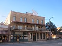
Eklund Hotel (established 1905), 2010
-
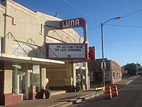
Luna Theater, 2010
-
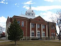
Union County Courthouse, 2008


See also
 In Spanish: Clayton (Nuevo México) para niños
