Kiowa National Grassland facts for kids
Quick facts for kids Kiowa National Grassland |
|
|---|---|

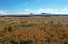
Kiowa National Grassland with Rabbit Ear Mountains in the background.
|
|
| Location | Northeastern New Mexico, USA |
| Nearest city | Clayton, NM |
| Area | 137,131 acres (554.95 km2) |
| Established | 1960 |
| Governing body | U.S. Forest Service |
| Website | Kiowa and Rita Blanca National Grasslands |
The Kiowa National Grassland is a special protected area in northeastern New Mexico. It's a huge grassland that's part of the Great Plains. Here you can find wide-open prairie lands and even a part of the amazing Canadian River Canyon. It's a great place to explore nature and learn about the history of the American West.
Contents
Where is Kiowa National Grassland?
The Kiowa National Grassland is made up of two separate areas in northeastern New Mexico. The western part is located in the northwestern area of Harding County, along with parts of Mora and Colfax counties. The smaller eastern part is in Union County, right near the borders of Oklahoma and Texas.
This grassland covers a huge area! It's about 137,131 acres (55,495 ha) in total. That's a lot of space for plants, animals, and outdoor adventures.
Who Manages the Grassland?
The U.S. Forest Service takes care of the Kiowa National Grassland. They also manage other grasslands and forests, like the Cibola National Forest. Their main office is in Albuquerque, New Mexico. There are also local offices in Clayton that help manage the area.
Nearby Towns and Communities
The small community of Mills is located within the western part of the Kiowa National Grassland. For the eastern part, the town of Clayton is the closest place to find supplies or services.
What is the Grassland Like?
Both parts of the Kiowa National Grassland are a mix of public land and private land. This means you'll see different types of property as you explore.
Weather and Landscape
The grassland sits at an elevation of about 4,500 to 6,300 feet (1,400 to 1,900 m) above sea level. This high elevation helps keep the summer temperatures a bit cooler than other parts of the Great Plains. In July, the average high temperature in Clayton is around 87 °F (31 °C), and the low is 60 °F (16 °C). In January, it's colder, with highs around 47 °F (8 °C) and lows around 20 °F (−7 °C).
The area gets about 15 inches (380 mm) of rain each year. Most of the rain falls in July and August, while January and February are the driest months.
Plants and Trees
Most of the Kiowa National Grassland (about 79 percent) is covered in semi-arid steppe grassland, also known as shortgrass prairie. This means you'll see lots of grasses that are good at living in dry conditions.
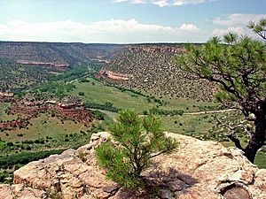
About ten percent of the land has Pinyon and Juniper trees, mostly in the western part. You can also find some Ponderosa Pine trees in the Canadian River Canyon. Other plants include Sand Sagebrush and trees like Cottonwood and Willow near water sources.
The Canadian River is the only river that flows all year round. You might also see Playa lakes, which are shallow lakes that fill up with rainwater during certain times of the year.
Ranching and Wildlife
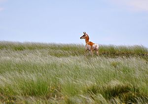
A big part of the Kiowa National Grassland is used by ranchers to graze cattle. This is an important economic activity for the area. The grassland is also home to many types of wildlife.
Fun Things to Do
The Kiowa National Grassland offers many opportunities for outdoor fun and learning about history.
Eastern Unit Adventures
- McNees Crossing: About 22 miles northeast of Clayton, you'll find McNees Crossing. This was an important water stop on the historic Santa Fe Trail. In the past, traders used this trail. You can learn about its history, including a story from 1828 when two young traders were killed here. A short trail leads to a historical marker.
- Santa Fe Trail Section: Seventeen miles north of Clayton, there's a three-mile section of the Santa Fe Trail that you can explore. It's perfect for walking or horseback riding. You can still see the ruts left by wagons that traveled this way almost 200 years ago!

Western Unit Exploration
- Canadian River Canyon (Mills Canyon): Six miles west of the community of Mills, you'll find the rim of the Canadian River Canyon, also called Mills Canyon. About 15 miles of this beautiful red-rock canyon are within the National Grassland. The canyon is about 700 feet (210 m) deep and more than 1 mi (1.6 km) wide!
- Camping and Hiking: There's a basic campground on the canyon rim. You can also find a road that goes down into the canyon, which is great for walking, horseback riding, or driving a high-clearance vehicle.
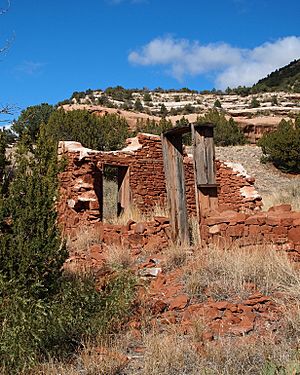
- Historical Ruins: On the canyon floor, you can see the ruins of Melvin Mills' old homestead. He had an apple orchard and a home here in the early 1900s.
- Wildlife: The canyon is full of wildlife, including Barbary Sheep, which thrive among the cliffs. The Canadian River is also a good spot for fishing, with fish like Largemouth Bass and Channel Catfish.
Protecting the Wilderness
In 2008, a proposal was made to create a wilderness area covering 6,032 acres (2,441 ha) in the Cimarron River Canyon. This would help protect about eight miles of the canyon, keeping it in its natural, untouched state. In a wilderness area, activities like fishing, hunting, and non-motorized travel (like hiking) are allowed.
 | James B. Knighten |
 | Azellia White |
 | Willa Brown |


