Amistad, New Mexico facts for kids
Quick facts for kids
Amistad, New Mexico
|
|
|---|---|

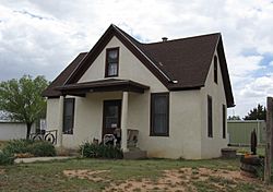
Amistad Museum, May 2008
|
|
| Country | United States |
| State | New Mexico |
| County | Union |
| Elevation | 4,472 ft (1,363 m) |
| Population | |
| • Total | 137 |
| Time zone | UTC-7 (MST) |
| • Summer (DST) | UTC-6 (MDT) |
| ZIP Code |
88410
|
| Area code(s) | 575 |
| GNIS feature ID | 898619 |
Amistad is a small place in Union County, New Mexico, United States. It is called an unincorporated community. This means it's a group of homes and businesses that isn't officially a town or city. It's about 39 miles south of Clayton. You can find it along State Route 402.
Contents
History of Amistad
Early Days and Cattle Drives
Amistad was an important stop in the late 1800s. It was a place where cowboys would rest during long cattle drives. These drives moved large groups of cattle across the country.
How Amistad Got Its Name
In 1906, a minister named Henry S. Wannamaker helped people move to the area. He was a Congregational minister. He put ads in church newspapers to encourage people to get land. This was part of the Homestead Act. This act allowed people to claim land from the government if they promised to live on it and improve it.
More than 40 older ministers decided to move to Amistad. They formed a group called "The Improvement Association." They chose the name Amistad for their new community. Amistad is a Spanish word that means friendship.
Growing and Changing
A post office was opened in Amistad in 1907. At one point, the community even had two local newspapers! Over the years, fewer people lived there. But Amistad is still a place where people live today.
 | James B. Knighten |
 | Azellia White |
 | Willa Brown |


