Carrollton, Texas facts for kids
Quick facts for kids
Carrollton, Texas
|
||
|---|---|---|
|
Carrollton Water Tower
|
||
|
||

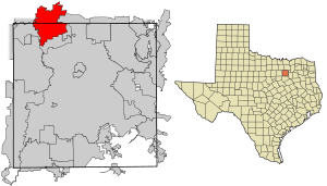
Location in Dallas County and the state of Texas
|
||
| Country | ||
| State | ||
| Counties | Dallas, Denton, Collin | |
| Government | ||
| • Type | Council-Manager | |
| Area | ||
| • Total | 37.43 sq mi (96.94 km2) | |
| • Land | 36.66 sq mi (94.94 km2) | |
| • Water | 0.77 sq mi (2.00 km2) 2.19% | |
| Elevation | 482 ft (147 m) | |
| Population
(2020)
|
||
| • Total | 133,454 | |
| • Estimate
(2021)
|
133,251 | |
| • Density | 3,565.4/sq mi (1,376.67/km2) | |
| Time zone | UTC−6 (Central) | |
| • Summer (DST) | UTC−5 (Central) | |
| ZIP codes |
75006, 75007, 75010, 75011
|
|
| Area code(s) | 214, 469, 945, 972 | |
| FIPS code | 48-13024 | |
| GNIS feature ID | 2409992 | |
| Website | http://www.cityofcarrollton.com | |
Carrollton is a city in Texas, a state in the United States. It is located in three different counties: Dallas, Denton, and Collin. In 2020, about 133,434 people lived there. This makes Carrollton the 27th largest city in Texas.
Contents
History of Carrollton
The Carrollton area was first settled in 1842 by Jared Ford. Later, in 1844, the A. W. Perry family claimed land nearby. They worked with Wade H. Witt to build a mill.
Many early settlers came from Carrollton, Illinois. This is likely how the Texas city got its name. These families, like the Furneaux and Jackson families, owned large areas of land.
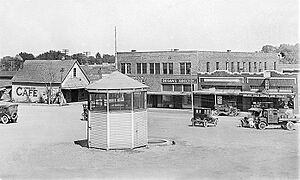
At first, Carrollton was mostly a farming community. But things changed when the Dallas-Wichita Railroad was built in 1878. This helped the town grow in importance for industries. The railroad was extended to Denton in 1880. By 1885, Carrollton had flour mills, cotton gins, two churches, and a school. About 150 people lived there.
Another railroad, the "Cotton Belt," crossed through in 1888. Carrollton became a busy shipping center for farm products and animals. This helped it grow bigger than nearby Trinity Mills.
In 1913, Carrollton officially became a city. W.F. Vinson was elected as its first mayor. A gravel industry started in 1912, and by the late 1940s, Carrollton was known as a "grain and gravel" town. It also had a brick plant and a dairy industry.
After World War II, Carrollton grew very quickly. Its population jumped from 1,610 in 1950 to 13,855 in 1970. As Dallas grew, many people moved to Carrollton, making it a popular suburb. Between 1970 and 1980, the population grew by 193% to 40,595 people! By 2010, over 119,000 people called Carrollton home.
Carrollton has been recognized as a great place to live. In 2006, Money magazine named it the 19th best place to live in the United States. In 2008, it was ranked the 15th best place to live among smaller cities.
Carrollton's Location and Weather
| Weather chart for Carrollton, Texas | |||||||||||||||||||||||||||||||||||||||||||||||
|---|---|---|---|---|---|---|---|---|---|---|---|---|---|---|---|---|---|---|---|---|---|---|---|---|---|---|---|---|---|---|---|---|---|---|---|---|---|---|---|---|---|---|---|---|---|---|---|
| J | F | M | A | M | J | J | A | S | O | N | D | ||||||||||||||||||||||||||||||||||||
|
1.9
55
36
|
2.3
61
41
|
3.1
69
49
|
3.5
77
56
|
5.3
84
65
|
3.9
92
73
|
2.4
96
77
|
2.2
96
76
|
2.7
89
69
|
4.7
79
58
|
2.6
66
47
|
2.5
57
39
|
||||||||||||||||||||||||||||||||||||
| temperatures in °F precipitation totals in inches source: Weather.com / NWS |
|||||||||||||||||||||||||||||||||||||||||||||||
|
Metric conversion
|
|||||||||||||||||||||||||||||||||||||||||||||||
Carrollton covers about 96 square kilometers (37 square miles). Most of this area is land, with a small part being water. As mentioned, Carrollton is unique because it's located in parts of three different counties: Dallas, Denton, and Collin.
Climate in Carrollton
Carrollton has a humid subtropical climate. This means it has hot, humid summers and mild winters. July is usually the warmest month. The highest temperature ever recorded was 112 degrees Fahrenheit (44 degrees Celsius) in 1980. January is typically the coolest month. The lowest temperature ever recorded was 1 degree Fahrenheit (minus 17 degrees Celsius) in 1989. May usually gets the most rain.
People of Carrollton
| Historical population | |||
|---|---|---|---|
| Census | Pop. | %± | |
| 1920 | 573 | — | |
| 1930 | 689 | 20.2% | |
| 1940 | 921 | 33.7% | |
| 1950 | 1,610 | 74.8% | |
| 1960 | 4,242 | 163.5% | |
| 1970 | 13,855 | 226.6% | |
| 1980 | 40,595 | 193.0% | |
| 1990 | 82,169 | 102.4% | |
| 2000 | 109,576 | 33.4% | |
| 2010 | 119,097 | 8.7% | |
| 2020 | 133,434 | 12.0% | |
| 2023 (est.) | 132,918 | 11.6% | |
| U.S. Decennial Census | |||
Carrollton has grown a lot since 1920, when only 573 people lived there. By 2020, the population had reached 133,434. This growth shows how popular Carrollton has become as a suburb of Dallas.
The city is home to many different groups of people, making it a very diverse place. In 2020, about 37% of the people were non-Hispanic white. Hispanic or Latino people made up about 31% of the population. There are also significant numbers of Black or African American people (nearly 10%) and Asian Americans (almost 17%). This mix of cultures makes Carrollton a vibrant community.
Carrollton's Economy
| # | Employer | # of Employees |
|---|---|---|
| 1 | AmerisourceBergen | 1500 |
| 2 | Halliburton | 1000 |
| 3 | Thomson Reuters | 1000 |
| 4 | Western Extrusions | 850 |
| 5 | Securus Technologies | 800 |
| 6 | AER Manufacturing Inc. | 750 |
| 7 | Baylor Scott & White | 640 |
| 8 | Fairway Mortgage Company | 550 |
| 9 | G6 Hospitality | 500 |
| 10 | Hilton Reservations Worldwide | 450 |
Carrollton has its own strong economy, even though it's close to Dallas. Many important companies have their main offices or big operations here. These include FASTSIGNS International, Inc., Halliburton's Easywell, Heelys, Inc., Motel 6 (G6 Hospitality), SECURUS Technologies, and Woot Inc. (which is part of Amazon).
Carrollton also has the largest Korean community in Texas and the southern United States. There's a special area called Koreatown Carrollton. It's full of many Asian restaurants and businesses. This helps the local economy grow and makes the city a fun place to visit.
Education in Carrollton
Most students in Carrollton attend schools in the Carrollton-Farmers Branch Independent School District (CFBISD). Some parts of the city are also served by the Dallas Independent School District (DISD) and the Lewisville Independent School District (LISD). A small section in Collin County is part of the Plano Independent School District (PISD).
CFBISD has three high schools in Carrollton: Newman Smith High School, R.L. Turner High School, and Creekview High School. LISD operates Hebron High School.
There are also several private schools and charter schools in Carrollton. For older students, there are colleges nearby like Dallas College, Collin College, and North Central Texas College.
Carrollton has two public libraries: Hebron & Josey and Josey Ranch Lake. The Japanese School of Dallas, which helps Japanese students keep up with their studies, holds classes at Ted Polk Middle School in Carrollton.
Getting Around Carrollton
Carrollton is well-connected to the wider Dallas area by major highways. These include Interstate 35E, the President George Bush Turnpike, and the Sam Rayburn Tollway.
For air travel, Dallas/Fort Worth International Airport is only about five miles away. Dallas Love Field is also nearby, about eight miles south.
The city also has public transportation through Dallas Area Rapid Transit's (DART) light rail system. The Green Line has stops in Carrollton, including North Carrollton/Frankford Station, Trinity Mills, and Downtown Carrollton. Trinity Mills is also where you can catch the A-train, which goes to Lewisville and Denton. The Silver Line is a new train line that will also have a stop in Downtown Carrollton.
Famous People from Carrollton
Many talented people have lived in or come from Carrollton, including:
- Anthony Ampaipitakwong, a soccer player
- Carson Blair, a former baseball catcher for the Oakland Athletics
- David Blough, a quarterback for the NFL's Minnesota Vikings, who went to Creekview High School
- Ashley Cain, a champion figure skater
- Rafael Cruz, father of U.S. Senator Ted Cruz
- Laganja Estranja, a drag performer from RuPaul's Drag Race
- Cherami Leigh, an actress and voice actress
- Rhema Marvanne, a child gospel singer
- Jason Maxiell, a former NBA player for the Detroit Pistons, who attended Newman Smith High School
- Katie Meili, an Olympic swimmer who won gold and bronze medals
- Keith Moreland, a professional baseball player and broadcaster
- Noah Ringer, a Taekwondo champion and actor in The Last Airbender
- Ryan Russell, a professional football player
- Melissa Rycroft, a former Dallas Cowboys cheerleader and TV personality
- Taylor Teagarden, a former baseball catcher for the Baltimore Orioles
- Vanilla Ice (Robert Van Winkle), a famous rapper and TV star
- Deron Williams, a former NBA player for the Cleveland Cavaliers
- Travis Wilson, a former NFL wide receiver for the Cleveland Browns
See also
 In Spanish: Carrollton (Texas) para niños
 | Dorothy Vaughan |
 | Charles Henry Turner |
 | Hildrus Poindexter |
 | Henry Cecil McBay |


