Pantego, Texas facts for kids
Quick facts for kids
Town of Pantego
|
|
|---|---|

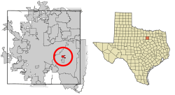
Location of Pantego in Tarrant County, Texas
|
|
| Country | United States |
| State | Texas |
| County | Tarrant |
| Incorporated (city) | May 22, 1952 |
| Area | |
| • Total | 1.04 sq mi (2.70 km2) |
| • Land | 1.04 sq mi (2.70 km2) |
| • Water | 0.00 sq mi (0.00 km2) |
| Elevation | 587 ft (179 m) |
| Population
(2020)
|
|
| • Total | 2,568 |
| • Estimate
(2021)
|
2,528 |
| • Density | 2,469/sq mi (951.1/km2) |
| Time zone | UTC-6 (CST) |
| • Summer (DST) | UTC-5 (CDT) |
| ZIP code |
76013
|
| Area code(s) | 817 |
| FIPS code | 48-55020 |
| GNIS feature ID | 2413106 |
| Website | http://www.townofpantego.com |
Pantego is a town in Tarrant County, Texas, United States. In 2020, about 2,568 people lived there. It is special because it is completely surrounded by the bigger cities of Arlington and Dalworthington Gardens. Pantego is also part of a very large area called the Dallas–Fort Worth metroplex, which is a big group of cities and towns.
Contents
History of Pantego

Early Explorers and Settlers
The first Europeans to visit this area might have been explorers led by Luis de Moscoso in 1542. They are thought to have camped near a place now called Village Creek. European settlers started arriving in the Pantego area around the 1840s. After a battle in 1841 between Texas General Edward H. Tarrant and Native Americans, a trading post was set up. The rich soil in the area attracted many farmers. By the late 1800s, several businesses related to farming were doing well.
How Pantego Got Its Name
After the Civil War, a settler and state representative named Frederick Forney Foscue bought the land that is now Pantego. He bought land, then sold and rented it to other settlers. This makes him the first land developer of Pantego.
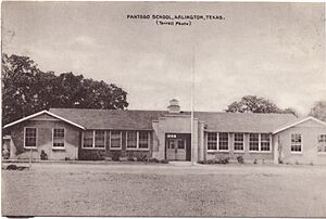
According to local stories, Colonel Foscue had a Native American friend named Pantego. In 1883, Colonel Foscue gave land for a school. People say the school was named Pantego to honor his friend. The town grew shortly after and took the name Pantego. You can still see this history in the town's logo, which features a feather.
Town Incorporation
Pantego first became an official town in 1949. However, it stopped being a town in February 1952. It then became an official town again on May 22, 1952.
Geography of Pantego
Location and Size
According to the United States Census Bureau, the town of Pantego covers about 1.0 square mile (2.6 square kilometers). All of this area is land. There are no large bodies of water within the town limits.
Surrounding Cities
Pantego's southern border touches Dalworthington Gardens. Both Pantego and Dalworthington Gardens are completely surrounded by the much larger city of Arlington. This means you have to drive through Arlington to get to Pantego or Dalworthington Gardens.
Population and People
| Historical population | |||
|---|---|---|---|
| Census | Pop. | %± | |
| 1950 | 646 | — | |
| 1960 | 238 | −63.2% | |
| 1970 | 1,779 | 647.5% | |
| 1980 | 2,431 | 36.6% | |
| 1990 | 2,371 | −2.5% | |
| 2000 | 2,318 | −2.2% | |
| 2010 | 2,394 | 3.3% | |
| 2020 | 2,568 | 7.3% | |
| 2021 (est.) | 2,528 | 5.6% | |
| U.S. Decennial Census | |||
Population Changes Over Time
The population of Pantego has changed over the years. The table to the right shows how many people lived in Pantego during different census years. In 2020, the town had 2,568 residents.
Who Lives in Pantego?
| Race | Number | Percentage |
|---|---|---|
| White (NH) | 1,927 | 75.04% |
| Black or African American (NH) | 144 | 5.61% |
| Native American or Alaska Native (NH) | 14 | 0.55% |
| Asian (NH) | 47 | 1.83% |
| Some other race (NH) | 18 | 0.7% |
| Mixed/multiracial (NH) | 123 | 4.79% |
| Hispanic or Latino | 295 | 11.49% |
| Total | 2,568 |
As of the 2020 United States census, there were 2,568 people living in Pantego. These people made up 1,064 households, with 672 of those being families. The table above shows the different racial and ethnic groups living in Pantego in 2020.
Education in Pantego
Colleges and Universities
Pantego itself does not have any colleges or universities. However, it is very close to Arlington and the rest of the Dallas/Fort Worth metropolitan area. This larger area has many colleges and universities. Some of these include the University of Texas at Arlington, the Southeast Campus of the Tarrant County College system, and Arlington Baptist University. This means students in Pantego have many options for higher education nearby.
Public Schools
Pantego is part of the Arlington Independent School District (AISD). This means that students living in Pantego go to schools within the AISD. Specifically, students from Pantego are assigned to:
- Hill Elementary School
- Bailey Junior High School
- Arlington High School
In Texas, school district boundaries are not always the same as city or county boundaries. This is because school districts have their own separate governments. For Pantego, a separate school district was never created. Instead, the already established Arlington ISD has served the entire town of Pantego since the mid-20th century.
Private Schools
Pantego Christian Academy has buildings located both within Pantego and Arlington. Around 2008, the school bought a 57,000 square foot (5,300 square meter) building. This building, located at 2221 West Park Row Drive, is used as their high school campus.
See also
 In Spanish: Pantego (Texas) para niños
 | James Van Der Zee |
 | Alma Thomas |
 | Ellis Wilson |
 | Margaret Taylor-Burroughs |


