Mulberry Creek (Red River tributary) facts for kids
Quick facts for kids Mulberry Creek |
|
|---|---|

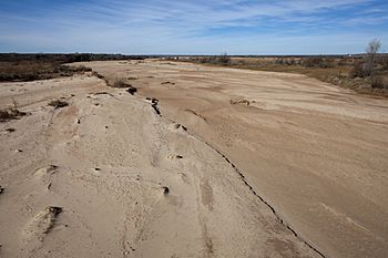
Sandy bed of Mulberry Creek, Hall County, Texas
|
|
| Physical characteristics | |
| Main source | Armstrong County, Texas 3,443 ft (1,049 m) 35°06′50″N 101°31′26″W / 35.113941°N 101.523785°W |
| River mouth | Hall County, Texas 2,029 ft (618 m) 34°36′46″N 100°52′31″W / 34.612655°N 100.875232°W |
| Length | 58 mi (93 km) |
| Basin features | |
| River system | Red River of the South |
| Tributaries |
|
Mulberry Creek is a special kind of stream in Texas. It's about 58 miles (93 km) long. This creek starts as a shallow dip in the high plains of the Llano Estacado in Armstrong County, Texas. From there, it flows southeast until it joins the Prairie Dog Town Fork Red River in Hall County, Texas.
Contents
Understanding Mulberry Creek
Mulberry Creek is known as an intermittent stream. This means it doesn't always have water flowing in it. Instead, it flows only after heavy rainstorms. When a lot of rain falls, the water runs off the land and fills the creek bed.
Where Does the Water Come From?
The creek begins on the high plains, which are very flat areas. These plains are part of a large region called the Llano Estacado. The water that forms the creek comes from rain that collects in shallow dips in this flat land.
What is an Ephemeral Draw?
The very beginning of Mulberry Creek is called an ephemeral draw. An ephemeral draw is like a small ditch or valley that only carries water for a short time. This happens right after a big rain. Most of the time, these draws are dry.
Mulberry Creek's Journey
Mulberry Creek starts its journey in Armstrong County. It flows towards the southeast. Along its path, the creek drops off a big cliff-like edge. This edge is known as the Caprock Escarpment.
Crossing the Caprock
The Caprock Escarpment is a major landform in Texas. It marks where the flat high plains end and the land drops down. Mulberry Creek crosses this escarpment just south of a town called Claude, Texas.
Flowing Through Ranch Country
After dropping off the Caprock, the stream continues its journey. It flows southeast through areas with very few people. This land is mostly used for ranches in eastern Armstrong County and western Hall County. Finally, it meets up with the Prairie Dog Town Fork Red River.
How Far Does It Drop?
From where it starts to where it joins the Prairie Dog Town Fork, Mulberry Creek drops a lot in elevation. It goes down about 1,414 feet (431 meters). This means the land it flows over changes from flat to quite steep in some places.
 | Aaron Henry |
 | T. R. M. Howard |
 | Jesse Jackson |

