Tierra Blanca Creek facts for kids
Quick facts for kids Tierra Blanca Creek |
|
|---|---|

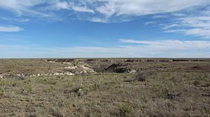
Canyon carved by Tierra Blanca Creek
|
|

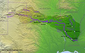
Map of the Red River watershed
|
|
| Country | United States |
| Physical characteristics | |
| Main source | Curry County, New Mexico 4,524 ft (1,379 m) 34°49′45″N 103°13′22″W / 34.8292321°N 103.2227271°W |
| River mouth | Randall County, Texas 3,471 ft (1,058 m) 35°00′10″N 101°54′09″W / 35.002778°N 101.902500°W |
| Length | 109 mi (175 km) |
Tierra Blanca Creek is a special stream in the southwestern United States. It starts in Curry County, New Mexico, and flows across a large, flat area called the Llano Estacado. This creek is about 75 miles (120 km) long. It eventually joins Palo Duro Creek in Randall County, Texas. Together, they form part of the Prairie Dog Town Fork Red River.
This creek helped create a huge place called Palo Duro Canyon. This canyon is the second largest in the United States. Tierra Blanca Creek drops about 1,050 feet (320 meters) from where it begins to where it meets Palo Duro Creek.
Contents
Water Levels and Challenges
The amount of water in Tierra Blanca Creek changes a lot. It is an ephemeral stream, which means it only flows sometimes. During dry periods, parts of the creek can become very small or even completely dry. This happens often because the area has a semi-arid climate, meaning it doesn't get much rain.
Flash Floods
Even though it can dry up, the creek also experiences big floods. It is the only stream bed that drains a large area. When strong thunderstorms happen, the creek can quickly fill with a lot of water. These sudden, powerful floods are called flash floods.
Why Water Levels Are Lower
Over time, the amount of water in Tierra Blanca Creek has decreased. This is mainly because of two reasons. First, dams have been built along the creek. Second, water is pumped out of the Ogallala Aquifer for farming. The Ogallala Aquifer is a huge underground water source.
History and Importance
Tierra Blanca Creek was very important in the past. It was the main source of water for the XIT Ranch. This ranch was one of the biggest cattle ranches in American history. The creek's water was essential for the cattle and people living there.
The creek also played a big role in shaping Palo Duro Canyon. Over thousands of years, the flowing water slowly carved out the deep, impressive canyon we see today.
What Does "Tierra Blanca" Mean?
The name "Tierra Blanca" comes from the Spanish language. It means "white earth." There are a couple of ideas about why the creek was given this name.
One idea is that the name refers to white clay deposits. These deposits are found along the sides of the valley where the creek flows. Another idea suggests the name comes from white caliche that can be seen along the valley walls. Caliche is a hardened layer of calcium carbonate, often found in dry regions.
 | Toni Morrison |
 | Barack Obama |
 | Martin Luther King Jr. |
 | Ralph Bunche |

