Jackson County, Oklahoma facts for kids
Quick facts for kids
Jackson County
|
|
|---|---|

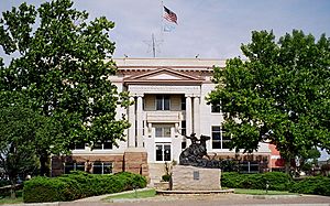
Jackson County Courthouse in Altus
|
|

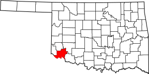
Location within the U.S. state of Oklahoma
|
|
 Oklahoma's location within the U.S. |
|
| Country | |
| State | |
| Founded | 1907 |
| Named for | Stonewall Jackson |
| Seat | Altus |
| Largest city | Altus |
| Area | |
| • Total | 804 sq mi (2,080 km2) |
| • Land | 803 sq mi (2,080 km2) |
| • Water | 1.6 sq mi (4 km2) 0.2%% |
| Population
(2020)
|
|
| • Total | 24,785 |
| • Density | 31/sq mi (12/km2) |
| Time zone | UTC−6 (Central) |
| • Summer (DST) | UTC−5 (CDT) |
| Congressional district | 3rd |
Jackson County is a county in the southwestern part of Oklahoma, a U.S. state. In 2020, about 24,785 people lived here. The main city and government center is Altus.
The county was named after important historical figures. Some say it was named for President Andrew Jackson. Others believe it was named for Confederate General Stonewall Jackson. It is also possible it was named for both of them. Jackson County is part of the Altus, OK area, which is a smaller city area.
Contents
A Look at Jackson County's History
This section explores how Jackson County became what it is today.
How Jackson County Was Formed
Long ago, there was a disagreement between the United States and Texas. They both claimed a large area of land. This land was known as Greer County, Texas.
In 1896, the highest court in the U.S., the Supreme Court, decided the land belonged to the United States. This area then became part of the Oklahoma Territory.
When Oklahoma became the 46th state in 1907, the old "Greer County" was split up. This is how Jackson County was created. Parts of it also became Greer and Beckham counties.
Altus: The County Seat
From the start, Altus was chosen as the main city for Jackson County. Another town, Olustee, tried to become the county seat in 1908. However, Altus remained the county's center.
Exploring Jackson County's Geography
Jackson County covers a total area of about 804 square miles. Most of this is land, with only a small part being water.
Land and Rivers
Most of the county is flat land with reddish soil, known as the Red Bed Plains. The western part has hills made of gypsum. The northeastern part touches the Wichita Mountains.
The county has several important rivers. The Red River flows through it. Its branches, the North Fork of the Red River and the Salt Fork of the Red River, also help drain the land.
Main Roads in Jackson County
These highways help people travel through the county:
Neighboring Counties
Jackson County shares borders with these other counties:
- Greer County (north)
- Kiowa County (northeast)
- Tillman County (east)
- Wilbarger County, Texas (south)
- Hardeman County, Texas (southwest)
- Harmon County (west)
People of Jackson County
| Historical population | |||
|---|---|---|---|
| Census | Pop. | %± | |
| 1910 | 23,737 | — | |
| 1920 | 22,141 | −6.7% | |
| 1930 | 28,910 | 30.6% | |
| 1940 | 22,708 | −21.5% | |
| 1950 | 20,082 | −11.6% | |
| 1960 | 29,736 | 48.1% | |
| 1970 | 30,902 | 3.9% | |
| 1980 | 30,356 | −1.8% | |
| 1990 | 28,764 | −5.2% | |
| 2000 | 28,439 | −1.1% | |
| 2010 | 26,446 | −7.0% | |
| 2020 | 24,785 | −6.3% | |
| U.S. Decennial Census 1790-1960 1900-1990 1990-2000 2010 |
|||
In 2000, there were about 28,439 people living in Jackson County. The population density was about 35 people per square mile. By 2020, the population had decreased to 24,785.
The county has a mix of different groups of people. In 2000, most residents were White. There were also significant numbers of Black, Native American, Asian, and Hispanic or Latino people.
Many households had children under 18 living with them. The average household had about 2.6 people. The average family size was about 3.1 people.
The median age in the county was 33 years old. This means half the people were younger than 33, and half were older.
Jackson County's Economy
The economy of Jackson County has always relied on farming and raising animals.
Main Industries
Farmers in the county grow crops like cotton, wheat, corn, and alfalfa. Hay is also an important crop. In the late 1940s, barley and sorghum became popular too.
People also raise animals such as horses, cattle, mules, pigs, and sheep.
Other Major Employers
Altus Air Force Base is the biggest employer in the county outside of farming. It provides many jobs for local residents.
By the year 2000, there were 16 manufacturing companies in Jackson County. These included companies like Altus Athletic Manufacturing and Bar-S Foods Company.
Education in Jackson County
Students in Jackson County have options for higher education.
Western Oklahoma State College (WOSC) is located in Altus. The Southwest Technology Center, also in Altus, offers technical training.
Communities in Jackson County
This section lists the towns and cities that make up Jackson County.
City
- Altus (This is the county seat, where the main government offices are.)
Towns
Unincorporated Communities
These are smaller communities that are not officially towns or cities.
Ghost Towns
These are places where towns once existed but are now abandoned.
See also
 In Spanish: Condado de Jackson (Oklahoma) para niños
 | Toni Morrison |
 | Barack Obama |
 | Martin Luther King Jr. |
 | Ralph Bunche |

