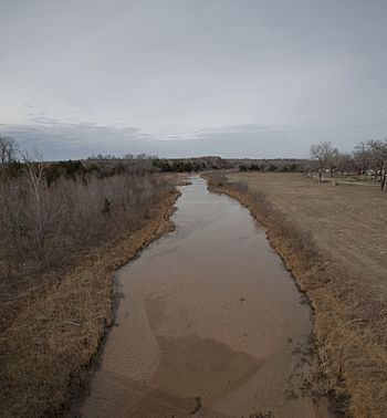
Salt Fork Red River facts for kids
Quick facts for kids Salt Fork Red River |
|
|---|---|

Salt Fork Red River, Collingsworth County, TX
|
|
| Country | United States |
| States | Texas, Oklahoma |
| Physical characteristics | |
| Main source | Llano Estacado 2.9 km (1.8 mi) north of Claude, Armstrong County, Texas 1,040 m (3,410 ft) 35°09′21″N 101°21′44″W / 35.15583°N 101.36222°W |
| River mouth | Confluence Red River 21 km (13 mi) south of Altus, Jackson County, Oklahoma 383 m (1,257 ft) 34°27′00″N 99°21′01″W / 34.45000°N 99.35028°W |
| Length | 311 km (193 mi) |
| Basin features | |
| Basin size | 5,180 km2 (2,000 sq mi) |
The Salt Fork Red River is a river that flows through parts of Texas and Oklahoma in the United States. It's about 311 km (193 mi) long. This river is known for its sandy banks.
It starts in West Texas on a high flat area called the Llano Estacado. This is near a town called Claude. The river then travels east across the Texas Panhandle and into Western Oklahoma. Finally, it joins the larger Red River near Altus.
Where the River Flows
The Salt Fork Red River begins its journey in northern Armstrong County, Texas. It flows towards the southeast. Along its path in Texas, it passes through Donley and Collingsworth County, Texas.
After leaving Texas, the river crosses into Oklahoma. It then flows through Harmon County and Greer County, Oklahoma. Near the town of Mangum, Oklahoma, the river turns south.
It continues its flow through Jackson County, Oklahoma. The Salt Fork Red River eventually meets the Red River. This meeting point is about 21 km (13 mi) south of Altus.
 | Madam C. J. Walker |
 | Janet Emerson Bashen |
 | Annie Turnbo Malone |
 | Maggie L. Walker |

