Donley County, Texas facts for kids
Quick facts for kids
Donley County
|
|
|---|---|

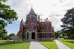
1890 Donley County Courthouse in Clarendon
|
|

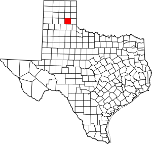
Location within the U.S. state of Texas
|
|
 Texas's location within the U.S. |
|
| Country | |
| State | |
| Founded | 1882 |
| Seat | Clarendon |
| Largest city | Clarendon |
| Area | |
| • Total | 933 sq mi (2,420 km2) |
| • Land | 927 sq mi (2,400 km2) |
| • Water | 6.2 sq mi (16 km2) 0.7% |
| Population
(2020)
|
|
| • Total | 3,258 |
| • Density | 3.4920/sq mi (1.3483/km2) |
| Time zone | UTC−6 (Central) |
| • Summer (DST) | UTC−5 (CDT) |
| Congressional district | 13th |
Donley County is a place in Texas, USA. In 2020, about 3,258 people lived there. The main town, or county seat, is Clarendon. Donley County was officially started in 1876 and set up in 1882.
Contents
History of Donley County
Donley County was created in 1876. It was named after Stockton P. Donley, who was a judge on the state's highest court. You can find several important historical places in Donley County that are listed on the National Register of Historic Places.
Geography of Donley County
Donley County covers about 933 square miles. Most of this area is land. Only a small part, about 5.6 square miles, is covered by water.
Main Roads in Donley County
These are the major highways that go through Donley County:
Neighboring Counties
Donley County shares borders with these other counties:
- Gray County (to the north)
- Wheeler County (to the northeast)
- Collingsworth County (to the east)
- Hall County (to the south)
- Briscoe County (to the southwest)
- Armstrong County (to the west)
- Carson County (to the northwest)
People of Donley County
The number of people living in Donley County has changed over time. In 1880, only 160 people lived here. The population grew a lot by 1930, reaching over 10,000 people. Since then, the population has slowly decreased. In 2020, 3,258 people lived in Donley County.
| Historical population | |||
|---|---|---|---|
| Census | Pop. | %± | |
| 1880 | 160 | — | |
| 1890 | 1,056 | 560.0% | |
| 1900 | 2,756 | 161.0% | |
| 1910 | 5,284 | 91.7% | |
| 1920 | 8,035 | 52.1% | |
| 1930 | 10,262 | 27.7% | |
| 1940 | 7,487 | −27.0% | |
| 1950 | 6,216 | −17.0% | |
| 1960 | 4,449 | −28.4% | |
| 1970 | 3,641 | −18.2% | |
| 1980 | 4,075 | 11.9% | |
| 1990 | 3,696 | −9.3% | |
| 2000 | 3,828 | 3.6% | |
| 2010 | 3,677 | −3.9% | |
| 2020 | 3,258 | −11.4% | |
| U.S. Decennial Census 1850–2010 2010 2020 |
|||
In 2000, there were 3,828 people living in the county. About 91% of the people were White. Around 4% were Black or African American. About 6% of the population was Hispanic or Latino.
The average age in Donley County in 2000 was 43 years old. About 22% of the people were under 18 years old.
Culture in Donley County
The Harold Dow Bugbee Ranch is in Donley County. This ranch used to belong to a famous Western artist named Harold Dow Bugbee. His wife, Olive Vandruff Bugbee, was also an artist.
U.S. Highway 287 goes through Donley County. Along this highway, there is a modern rest area. This rest area is special because it has a tornado shelter in its main building. This provides a safe place during bad weather.
Communities in Donley County
Donley County has a few towns and one unincorporated community.
Cities in Donley County
- Clarendon (This is the main town, also called the county seat)
- Hedley
- Howardwick
Unincorporated Community
- Lelia Lake
Notable Person from Donley County
- U.S. Representative Mac Thornberry
See also
 In Spanish: Condado de Donley para niños
 | DeHart Hubbard |
 | Wilma Rudolph |
 | Jesse Owens |
 | Jackie Joyner-Kersee |
 | Major Taylor |


