
Clarendon, Texas facts for kids
Quick facts for kids
Clarendon, Texas
|
|
|---|---|
|
City
|
|

Clarendon welcome sign on U.S. Highway 287
|
|

Location of Clarendon, Texas
|
|
 |
|
| Country | United States |
| State | Texas |
| County | Donley |
| Area | |
| • Total | 3.01 sq mi (7.79 km2) |
| • Land | 2.90 sq mi (7.52 km2) |
| • Water | 0.10 sq mi (0.27 km2) |
| Elevation | 2,743 ft (836 m) |
| Population
(2020)
|
|
| • Total | 1,877 |
| • Density | 623.6/sq mi (240.95/km2) |
| Time zone | UTC−6 (Central (CST)) |
| • Summer (DST) | UTC−5 (CDT) |
| ZIP code |
79226
|
| Area code(s) | 806 |
| FIPS code | 48-15112 |
| GNIS feature ID | 2409467 |
Clarendon is a small city in Donley County, Texas, in the United States. In 2020, about 1,877 people lived there. It is the main town, or county seat, of Donley County. Clarendon is found on U.S. Highway 287 in the Texas Panhandle. It's about 60 miles (97 km) east of Amarillo.
Contents
History of Clarendon
Clarendon was started in 1878. It was one of the first three settlements in the Texas Panhandle. The other two were Mobeetie and Tascosa. Clarendon had to move from its first spot. This happened because the Fort Worth and Denver Railway train tracks did not pass through the original town.
A Methodist church leader named L.H. Carhart founded the town. He wanted Clarendon to be a "sobriety settlement." This meant it would be a calm place, unlike the wild "boomtowns" of that time. Local cowboys called Clarendon "Saints Roost." This is why the local museum is called the Saints' Roost Museum.
On March 13, 2021, two tornadoes hit the town at the same time. The first tornado caused minor damage west of town. It then grew stronger and caused more serious damage on the north side. The second tornado damaged some homes and sheds in the town.
Geography of Clarendon
Clarendon is located southwest of the middle of Donley County. U.S. Highway 287 goes through the city. This highway leads west about 60 miles (97 km) to Amarillo. It goes southeast about 57 miles (92 km) to Childress. Texas State Highway 70 goes north about 17 miles (27 km) to Interstate 40. It goes south about 42 miles (68 km) to Turkey.
The city covers a total area of about 3.01 square miles (7.8 square kilometers). Most of this area is land. A small part, about 0.10 square miles (0.27 square kilometers), is covered by water.
Population Changes Over Time
The number of people living in Clarendon has changed over the years. Here is a look at the population from 1890 to 2020:
- 1890: 949 people
- 1910: 1,946 people
- 1920: 2,456 people
- 1930: 2,756 people
- 1940: 2,431 people
- 1950: 2,577 people
- 1960: 2,172 people
- 1970: 1,974 people
- 1980: 2,220 people
- 1990: 2,067 people
- 2000: 1,974 people
- 2010: 2,026 people
- 2020: 1,877 people
As of the 2020 United States census, there were 1,877 people living in Clarendon. There were 705 households and 404 families in the city.
Education in Clarendon
The Clarendon Consolidated Independent School District serves the city. The school colors are maroon, white, and black. The school mascot is the Bronco.
Clarendon is also home to Clarendon College. This college started in 1898. It is the oldest center for higher education in the Texas Panhandle. The college was first connected with the Methodist Church. It is located off Highway 287 in north Clarendon. The college mascot is the bulldog. Its colors are green and white.
Images for kids
-

The Sandell Drive-in theater reopened in 2002 after being closed since 1984.
-
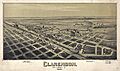
A map of Clarendon from 1890.
-
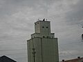
The grain elevator in Clarendon.
-
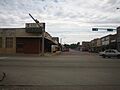
The streets of Clarendon.


See also
 In Spanish: Clarendon (Texas) para niños
