Mobeetie, Texas facts for kids
Quick facts for kids
Mobeetie, Texas
|
|
|---|---|

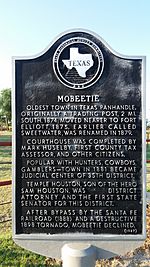
Texas Historical marker for Mobeetie
|
|
 |
|
| Country | United States |
| State | Texas |
| County | Wheeler |
| Area | |
| • Total | 0.61 sq mi (1.58 km2) |
| • Land | 0.61 sq mi (1.58 km2) |
| • Water | 0.00 sq mi (0.00 km2) |
| Elevation | 2,618 ft (798 m) |
| Population
(2020)
|
|
| • Total | 87 |
| • Density | 142.6/sq mi (55.1/km2) |
| Time zone | UTC-6 (Central (CST)) |
| • Summer (DST) | UTC-5 (CDT) |
| ZIP code |
79061
|
| Area code(s) | 806 |
| FIPS code | 48-48852 |
| GNIS feature ID | 2411128 |
Mobeetie is a small city in Wheeler County, Texas, United States. It is located near Sweetwater Creek and State Highway 152. In 2020, about 87 people lived in Mobeetie.
Contents
A Look at Mobeetie's Past
Mobeetie started as a trading post for hunters and trappers. It was near Fort Elliott, a U.S. Army outpost. At first, it was a camp for buffalo hunters, unofficially called "Hidetown." It was connected to Dodge City, Kansas, by a trail, making it a busy spot for stagecoaches and buffalo skinners. As the town grew, it helped nearby cattle ranches by providing supplies.
The first official name for the town was "Sweetwater." It was located on the North Fork Red River. Fort Elliott helped the town grow even more. The fort was built to protect the buffalo trade.
How Mobeetie Got Its Name
When the town wanted a post office in 1879, the name "Sweetwater" was already being used by another place. So, the town chose the new name "Mobeetie." People thought it was a Native American word for Sweetwater. However, it was later found out that the word actually meant "buffalo dung."
Mobeetie's Importance in Texas History
Because Fort Elliott was nearby and Mobeetie was an important trading center, Wheeler County became the first organized county in the Texas Panhandle in 1879. Mobeetie was the first county seat for Wheeler County.
From 1880 to 1883, a famous rancher named Robert Clay Allison lived and ranched with his brothers near Mobeetie. He even got married in Mobeetie in 1881.
Changes Over Time
At its busiest in 1890, Mobeetie had over 400 people. But the town's good times ended when Fort Elliott closed that same year. More problems came with a tornado in 1898. Then, in 1907, Mobeetie lost its role as the county seat to Wheeler.
In 1929, the town of Mobeetie actually moved about two miles. This happened because the Panhandle and Santa Fe Railway built new train tracks nearby. The town grew steadily again until World War II, when its population reached about 500.
Mobeetie is also known as the birthplace of Morrie Rath. He was a baseball player who was born on Christmas Day in 1886. He played for the 1919 World Series champion Cincinnati Reds.
Where is Mobeetie?
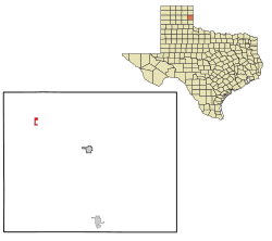
Mobeetie is in the Texas Panhandle. It is northeast of Sweetwater Creek. You can find it along Texas State Highway 152, Farm to Market Road 48, and Farm to Market Road 1046. Pampa is about 30 miles to the west. Wheeler is about 10 miles to the east along Highway 152. The historic site of Fort Elliott is about one mile west of Mobeetie.
The city covers an area of about 0.6 square miles (1.6 square kilometers), and all of it is land.
Population Changes
| Historical population | |||
|---|---|---|---|
| Census | Pop. | %± | |
| 1980 | 291 | — | |
| 1990 | 154 | −47.1% | |
| 2000 | 107 | −30.5% | |
| 2010 | 101 | −5.6% | |
| 2020 | 87 | −13.9% | |
| U.S. Decennial Census 2020 Census |
|||
In 2000, 107 people lived in Mobeetie. About 27% of households had children under 18. The average age of people in the city was 41 years old.
Schools in Mobeetie
The Fort Elliott Consolidated Independent School District serves the city of Mobeetie. The former Mobeetie Independent School District joined with FECISD in 1991.
Mobeetie's Climate
Mobeetie has a semiarid climate. This means it is usually dry, but not a desert.
See also
In Spanish: Mobeetie (Texas) para niños
 | Calvin Brent |
 | Walter T. Bailey |
 | Martha Cassell Thompson |
 | Alberta Jeannette Cassell |

