Greer County, Oklahoma facts for kids
Quick facts for kids
Greer County
|
|
|---|---|

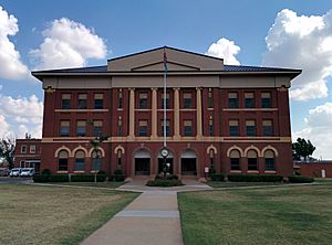
Greer County Courthouse in Mangum
|
|

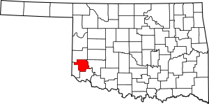
Location within the U.S. state of Oklahoma
|
|
 Oklahoma's location within the U.S. |
|
| Country | |
| State | |
| Founded | 1896 |
| Named for | John Alexander Greer |
| Seat | Mangum |
| Largest city | Mangum |
| Area | |
| • Total | 644 sq mi (1,670 km2) |
| • Land | 639 sq mi (1,660 km2) |
| • Water | 4.3 sq mi (11 km2) 0.7%% |
| Population
(2020)
|
|
| • Total | 5,491 |
| • Density | 8.526/sq mi (3.2921/km2) |
| Time zone | UTC−6 (Central) |
| • Summer (DST) | UTC−5 (CDT) |
| Congressional district | 3rd |
Greer County is a county located in the southwestern part of Oklahoma. In 2020, about 5,491 people lived there. The main town and county seat (where the county government is) is Mangum.
For many years, from 1860 to 1896, the state of Texas thought this area belonged to them. It was called Greer County, Texas. But in 1896, the U.S. Supreme Court decided it was part of Oklahoma Territory.
Greer County is mostly rural, meaning it has a lot of open land and farms. It's home to Quartz Mountain State Park, a beautiful place near Lone Wolf, Oklahoma. It also has the Oklahoma State Reformatory, a prison located in Granite. The number of people living in Greer County has gone down since the 1930s. This is because farming changed, and many people moved to cities to find jobs.
Contents
A Look Back: History of Greer County
For a long time, there was a big argument about who owned the land that is now Greer County. Both the United States government and the state of Texas claimed it. This argument started because of old treaties from 1819 and 1828. The county was named after John Alexander Greer, who used to be a lieutenant governor in Texas.
The argument went all the way to the Supreme Court. In 1896, the Supreme Court decided that the land belonged to the United States, not Texas.
After this decision, on May 4, 1896, the area became part of the Oklahoma Territory. When Oklahoma officially became a state, Greer County was set up with its current borders. The rest of the land that Texas used to claim was divided into other counties like Harmon, Jackson, and part of Beckham counties.
Mangum, which was already the county seat when it was part of Texas, stayed the county seat for Greer County, Oklahoma. For a period, until at least 1903, African Americans were not allowed to live in Greer County.
Greer County was first developed for farming. The most people lived there in 1930. But as farming became more modern with machines, fewer people were needed to work on farms. Because of this, many people moved away to cities to find other types of work.
One of the county's popular spots is Quartz Mountain State Park. It's a great place for outdoor activities and is located near the town of Lone Wolf.
Where is Greer County? Geography
The U.S. Census Bureau says that Greer County covers about 644 square miles. Most of this (about 639 square miles) is land, and a small part (about 4.3 square miles) is water.
The western part of Greer County has rolling hills called the Gypsum Hills. The eastern part is flatter and known as the Red Bed Plains. Several rivers flow through the county, including the North Fork Red River, Elm Fork Red River, and Salt Fork Red River.
Main Roads in Greer County
Neighboring Counties
- Beckham County (north)
- Kiowa County (east)
- Jackson County (south)
- Harmon County (west)
People of Greer County: Demographics
| Historical population | |||
|---|---|---|---|
| Census | Pop. | %± | |
| 1910 | 16,449 | — | |
| 1920 | 15,836 | −3.7% | |
| 1930 | 20,282 | 28.1% | |
| 1940 | 14,550 | −28.3% | |
| 1950 | 11,749 | −19.3% | |
| 1960 | 8,877 | −24.4% | |
| 1970 | 7,979 | −10.1% | |
| 1980 | 7,028 | −11.9% | |
| 1990 | 6,559 | −6.7% | |
| 2000 | 6,061 | −7.6% | |
| 2010 | 6,239 | 2.9% | |
| 2020 | 5,491 | −12.0% | |
| U.S. Decennial Census 1790–1960 1900–1990 1990–2000 2010 |
|||
In 2000, there were 6,061 people living in Greer County. About 2,237 households and 1,442 families called it home. The county had about 10 people per square mile.
About 25.6% of households had children under 18 living with them. Many households (51%) were married couples. About 20% of the population was under 18, and another 20% was 65 or older. The average age in the county was 40 years old.
What Drives the Economy?
Greer County's economy has always been based on farming and raising animals. In the early 1900s, farmers grew crops like cotton, corn, oats, wheat, and alfalfa. They also raised cattle, horses, mules, pigs, sheep, and goats.
The Oklahoma State Reformatory in Granite is a major employer in the county, providing many jobs.
Towns and Communities
Cities
- Mangum (This is the county seat!)
Towns
Small Communities (Unincorporated)
Schools in Greer County
Here are some of the school districts that serve students in Greer County:
- Blair Public Schools
- Duke Public Schools
- Erick Public Schools
- Granite Public Schools
- Hollis Public Schools
- Lone Wolf Public Schools
- Mangum Public Schools
- Merritt Public Schools
- Navajo Public Schools
- Sayre Public Schools
Famous People from Greer County
- Edward Everett Dale (1879–1972) - A well-known historian and professor at the University of Oklahoma.
- William T. Ponder (1891–1947) - A brave pilot who was a flying ace in World War I.
- Victor E. Wickersham (1906–1988) - A U.S. politician who served in the U.S. House of Representatives.
See also
 In Spanish: Condado de Greer para niños
 | Delilah Pierce |
 | Gordon Parks |
 | Augusta Savage |
 | Charles Ethan Porter |

