
National Register of Historic Places listings in Custer County, Oklahoma facts for kids

Custer County, located in Oklahoma, is home to several special places that are listed on the National Register of Historic Places. This register is like a national list of important buildings, sites, and objects that are worth preserving because of their history, architecture, or cultural significance.
These places tell stories about the past of Custer County and the wider United States. There are 14 different properties and areas in Custer County that have been added to this important list. They include old buildings, parks, and even some archaeological sites where people have found clues about ancient times.
Exploring Custer County's Historic Gems
Many of Custer County's historic places are found in its towns, like Clinton, Weatherford, Custer City, and Thomas. Each one has a unique story.
Historic Buildings in Custer City
In Custer City, you can find a few buildings that take you back in time.
- The Broadway Hotel is an old hotel that was once a busy spot for travelers. It's located right off State Highway 33.
- The First National Bank of Custer City is another historic building on State Highway 33. Banks were very important for communities as they grew.
- J.J. Pyeatt's General Store was a general store, which means it sold all sorts of things, from food to tools. It was a central place for people to shop and meet.
Important Sites in Clinton
Clinton has several places on the list:
- The Clinton Armory is a building that was used by the military or local guard. Armories often have unique designs.
- The Crawford House is a historic home that shows how people lived in the past.
- McLain Rogers Park is a park that has been recognized for its historical importance, perhaps for its design or how it was used by the community.
- The Y Service Station and Cafe is a historic gas station and diner. These places were very important when cars became popular, offering a place to refuel and eat.
Weatherford's Historical Spots
In Weatherford, you can find:
- The Owl Blacksmith Shop was where a blacksmith worked, making and repairing metal items. Blacksmiths were essential before modern factories.
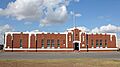
- The Science Building at Southwestern Oklahoma State University is a significant building on the university campus.
- The Weatherford Armory is another armory building, similar to the one in Clinton, showing the history of local defense.
Thomas Community Building
The Thomas Community Building in Thomas is a place where people gathered for events and meetings. Community buildings are often the heart of a town.
Ancient History: Archaeological Sites
Some listings are not buildings but important archaeological sites. These are places where scientists study the remains of ancient cultures. Their exact locations are kept secret to protect them.
- The Heerwald Site near Clinton.
- The Hodge Site near Hammon.
- The Little Deer Site near Weatherford.
These sites help us learn about the people who lived in Custer County thousands of years ago.
Images for kids
-
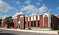
The Clinton Armory building.
-
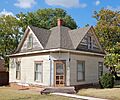
The historic Crawford House in Clinton.
-
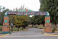
A view of McLain Rogers Park.
-

The Science Building at Southwestern Oklahoma State University.
-
The Weatherford Armory.

.JPG)


