
National Register of Historic Places listings in Seminole County, Oklahoma facts for kids

This page is all about special places in Seminole County, Oklahoma, United States! These places are so important that they are listed on the National Register of Historic Places. Think of it like a special hall of fame for buildings, sites, and objects that have played a big part in history.
The National Register of Historic Places is a list kept by the United States government. It helps protect and celebrate places that are important to American history, architecture, archaeology, engineering, or culture. When a place is on this list, it means it's recognized as a valuable part of our past.
In Seminole County, there are 18 amazing places that have earned a spot on this important list. You can even see where some of these places are on a map!
Discovering Seminole County's Historic Treasures
Seminole County is home to many buildings and sites that tell stories from long ago. Let's explore some of these cool places that are protected because of their history.
Homes with History
Some of the historic places are old homes that belonged to important people.
Alice Brown House
The Alice Brown House is located on Chestnut Street in Sasakwa. It was added to the list in 1982. This house is special because it connects us to the history of the area.
Jackson Brown House
In Wewoka, you can find the Jackson Brown House at 1200 S. Muskogee Place. This house became a historic site in 1980. It's a great example of the homes built in the past.

Silas L. Brown House
Another historic home in Wewoka is the Silas L. Brown House, found at 107 S. Seminole. It was added to the list in 1985. These homes help us imagine what life was like many years ago.
W.E. Grisso Mansion
The W.E. Grisso Mansion is a very grand house located at 612 State Highway 9E in Seminole. It was listed in 1975. This mansion shows us the fancy architecture of its time.

Important Buildings and Businesses
Many historic places are buildings that were once busy centers for business or community life.
Home Stake Oil and Gas Company Building
The Home Stake Oil and Gas Company Building, at 315 E. Broadway in Seminole, was added to the list in 1986. This building reminds us of the oil boom days in Oklahoma.

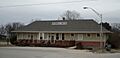
Hotel Aldridge
The Hotel Aldridge, located at 3rd Street and Wewoka Avenue in Wewoka, became a historic site in 1986. Hotels like this were once very important places for travelers and community events.

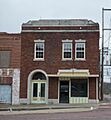
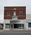
J. Coody Johnson Building
The J. Coody Johnson Building, at 124 N. Wewoka Street in Wewoka, was listed in 1985. This building likely played a role in the local economy and community.

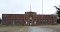
Konawa Armory
The Konawa Armory, found at 625 N. State Street in Konawa, was added to the list in 1994. Armories are buildings used by military or guard units, and this one has historical importance.

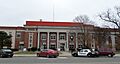
Seminole County Courthouse
The Seminole County Courthouse, at 120 S. Wewoka Avenue in Wewoka, was listed in 1984. Courthouses are very important buildings where laws are made and justice is served for the county.

Seminole Municipal Building
The Seminole Municipal Building, located at 401 N. Main Street in Seminole, is a more recent addition to the list, from 2015. This building serves as the center for city government.

Sinclair Loading Rack
The Sinclair Loading Rack, found along U.S. Route 270 in Seminole, was listed in 1985. This structure was used to load oil or other products onto trains, showing the industrial history of the area.

Unique Historic Sites
Some places on the list are not just buildings, but unique sites with special stories.
Mekasukey Academy
The Mekasukey Academy site is located southwest of Seminole and was listed in 1974. Academies like this were important schools, often for Native American children, playing a big role in education history.
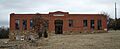
Rosenwald Hall
Rosenwald Hall, on College Street in Lima, was added to the list in 1984. Rosenwald Schools were special schools built for African American children in the early 20th century, and this hall is a reminder of that important history.

Roulston-Rogers Site
The Roulston-Rogers Site near Sasakwa is a place where archaeological discoveries have been made. Its exact location is kept private to protect its historical value, but it was listed in 1978.
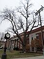
Seminole Whipping Tree
The Seminole Whipping Tree, located at 120 S. Wewoka Avenue in Wewoka, was listed in 1981. This site has a complex and important history related to justice and law enforcement in the past.

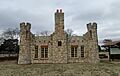
Strother Memorial Chapel
The Strother Memorial Chapel is inside the Maple Grove Cemetery at 1201 Van Drive in Seminole. It was added to the list in 2003. Chapels in cemeteries are often beautiful and peaceful places for remembrance.

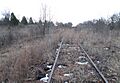
Wewoka Switch and Side Tracks
The Wewoka Switch and Side Tracks, located along State Highway 56 in Wewoka, were listed in 1985. These railway features are important for understanding how goods and people moved around in the past.

Images for kids
-
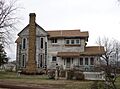
The historic Jackson Brown House in Wewoka.
-
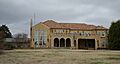
The impressive W.E. Grisso Mansion.
-
The Home Stake Oil and Gas Company Building.
-
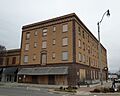
The historic Hotel Aldridge.
-
The J. Coody Johnson Building.
-
The Konawa Armory building.
-
Rosenwald Hall in Lima.
-

Image for a site with a restricted address.
-
The Seminole County Courthouse.
-

The Seminole Municipal Building.
-
The Seminole Whipping Tree.
-
The Sinclair Loading Rack.
-
The Strother Memorial Chapel.
-
The Wewoka Switch and Side Tracks.

