Seminole County, Oklahoma facts for kids
Quick facts for kids
Seminole County
|
|
|---|---|

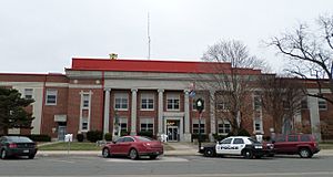
Seminole County Courthouse in Wewoka
|
|

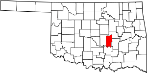
Location within the U.S. state of Oklahoma
|
|
 Oklahoma's location within the U.S. |
|
| Country | |
| State | |
| Founded | 1907 |
| Seat | Wewoka |
| Largest city | Seminole |
| Area | |
| • Total | 640 sq mi (1,700 km2) |
| • Land | 633 sq mi (1,640 km2) |
| • Water | 7.6 sq mi (20 km2) 1.2%% |
| Population
(2020)
|
|
| • Total | 23,556 |
| • Density | 36.81/sq mi (14.21/km2) |
| Congressional district | 5th |
Seminole County is a county located in the state of Oklahoma in the United States. In 2020, about 23,556 people lived there. The main town, or county seat, is Wewoka.
A big part of Seminole County was once a special area, or reservation, for the Seminole Nation of Oklahoma. They still have control over some land in the county today. A smaller piece of land on the east side belonged to the Muscogee (Creek) Nation.
Seminole County is famous for something called the Greater Seminole Field. This was one of the most important places where oil was ever found, and it still produces oil! It even stretches into other nearby counties. When the "oil boom" happened, lots of workers and people looking for adventure came to the county. This made the population grow very quickly. Later, when less oil was found, many jobs and people left.
Contents
History of Seminole County
Seminole County has been very important for the oil industry in Oklahoma and the United States for over 80 years. The Greater Seminole Field was a huge discovery. It is still producing oil today.
Oil companies found many oil fields one after another in 1926. They decided to give them a group name. Paul Hedrick, an oil editor for the Tulsa World newspaper, suggested the name "Greater Seminole Field."
Some of the first oil discoveries in the area were the Wewoka oil field and the Cromwell oil field. Both of these were found in 1923. Then, on July 16, 1926, the Fixico No. 1 well found oil deep underground. This started the Seminole City Field.
The Greater Seminole area includes 6 of Oklahoma's 22 biggest oil fields. These are Earlsboro, St. Louis, Seminole, Bowlegs, Little River, and Allen. Between 1926 and 1936, this area produced a huge amount of oil. It made up 18% of all the oil produced in Oklahoma during that time.
In 1927, the Maud field was discovered. This was special because it was the first time a new method called reflection seismology was used to find oil. This method uses sound waves to map what's underground. It was a big step forward for the oil industry.
The Seminole County Courthouse was built in 1927.
Geography of Seminole County
Seminole County covers about 640 square miles. Most of this is land, about 633 square miles. The rest, about 7.6 square miles, is water.
The North Canadian River forms the northern border of the county. The Canadian River forms the southern border.
Neighboring Counties
- Okfuskee County (to the northeast)
- Hughes County (to the east)
- Pontotoc County (to the south)
- Pottawatomie County (to the west)
Population of Seminole County
| Historical population | |||
|---|---|---|---|
| Census | Pop. | %± | |
| 1910 | 19,964 | — | |
| 1920 | 23,808 | 19.3% | |
| 1930 | 79,621 | 234.4% | |
| 1940 | 61,201 | −23.1% | |
| 1950 | 40,672 | −33.5% | |
| 1960 | 28,066 | −31.0% | |
| 1970 | 25,144 | −10.4% | |
| 1980 | 27,473 | 9.3% | |
| 1990 | 25,412 | −7.5% | |
| 2000 | 24,894 | −2.0% | |
| 2010 | 25,482 | 2.4% | |
| 2020 | 23,556 | −7.6% | |
| U.S. Decennial Census 1790-1960 1900-1990 1990-2000 2010 |
|||
In 2000, there were about 24,894 people living in Seminole County. By 2020, the population was 23,556.
The population changed a lot over the years. In 1930, during the oil boom, the population jumped to almost 80,000 people! After the oil production slowed down, the number of people living in the county went down.
Towns and Cities
Seminole County has several communities, from larger cities to smaller towns.
Cities
- Konawa
- Maud (partly in Pottawatomie County)
- Seminole
- Wewoka (This is the county seat)
Towns
Unincorporated Communities
These are smaller communities that are not officially organized as cities or towns.
Ghost Town
- Dewright (a town that no longer has people living in it)
Education
There are several school districts in Seminole County. These districts manage the public schools for children in different areas.
- Bowlegs Public Schools
- Butner Public Schools
- Konawa Public Schools
- Maud Public Schools
- New Lima Public Schools
- Sasakwa Public Schools
- Seminole Public Schools
- Strother Public Schools
- Varnum Public Schools
- Wewoka Public Schools
There is also one elementary school district called Justice Public School.
Images for kids
See also
 In Spanish: Condado de Seminole (Oklahoma) para niños
 | Roy Wilkins |
 | John Lewis |
 | Linda Carol Brown |


