Cromwell, Oklahoma facts for kids
Quick facts for kids
Cromwell, Oklahoma
|
|
|---|---|

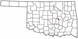
Location of Cromwell, Oklahoma
|
|
| Country | United States |
| State | Oklahoma |
| County | Seminole |
| Area | |
| • Total | 0.59 sq mi (1.53 km2) |
| • Land | 0.59 sq mi (1.53 km2) |
| • Water | 0.00 sq mi (0.00 km2) |
| Elevation | 961 ft (293 m) |
| Population
(2020)
|
|
| • Total | 238 |
| • Density | 401.35/sq mi (155.08/km2) |
| Time zone | UTC-6 (Central (CST)) |
| • Summer (DST) | UTC-5 (CDT) |
| ZIP code |
74837
|
| Area code(s) | 405 |
| FIPS code | 40-18450 |
| GNIS feature ID | 2412388 |
Cromwell is a small town in Seminole County, Oklahoma, United States. It is part of the Muscogee (Creek) Nation. In 2020, about 238 people lived there. The town was named after Joe I. Cromwell, an oilman who helped start the town in 1923.
When Cromwell first started, many people moved there quickly. It became a very busy place. To help keep order, a famous old-time lawman named Bill Tilghman became the Town Marshal. A sad event happened the next year when Tilghman passed away. This was a very important moment in Cromwell's early history.
Contents
History of Cromwell
Cromwell was founded in 1923. It was named after Joe I. Cromwell, who was a Muscogee oilman. The town got its own post office on May 17, 1924.
In the early 1920s, Cromwell was a very active town. It was known for being a place where many different kinds of people lived.
On Halloween night in 1924, Cromwell's Town Marshal, Bill Tilghman, was involved in a serious incident. Tilghman was a well-known lawman from the Old West. He had been asked to help bring more order to the town. He passed away in the early morning hours of November 1st. About a month later, a large fire damaged many buildings in Cromwell. The town changed a lot after that fire and never grew back to its earlier size.
Where is Cromwell?
Cromwell is located in Oklahoma. The United States Census Bureau says the town covers about 1.1 square miles (2.8 square kilometers). All of this area is land.
People in Cromwell
| Historical population | |||
|---|---|---|---|
| Census | Pop. | %± | |
| 1930 | 249 | — | |
| 1940 | 451 | 81.1% | |
| 1950 | 313 | −30.6% | |
| 1960 | 269 | −14.1% | |
| 1970 | 287 | 6.7% | |
| 1980 | 337 | 17.4% | |
| 1990 | 268 | −20.5% | |
| 2000 | 265 | −1.1% | |
| 2010 | 286 | 7.9% | |
| 2020 | 238 | −16.8% | |
| U.S. Decennial Census | |||
In the year 2000, there were 265 people living in Cromwell. The town had 97 households and 77 families. The population density was about 247.7 people per square mile.
The people living in Cromwell were of different ages. About 29.1% were under 18 years old. About 15.1% were 65 years old or older. The average age in the town was 40 years.
Schools in Cromwell
Cromwell is part of the Butner Public Schools school district. This district provides education for the children living in the town.
About Schoolton
Schoolton is a place that is now inside Cromwell's official town limits. It is located about 4 miles north of central Cromwell. You can find it on Oklahoma State Highway 56, just north of Interstate 40.
Schoolton had its own post office for a while, from 1907 to 1917. Before that, another post office called Irene was in the same area. The name Schoolton was chosen by a local teacher, William P. Weston. He picked the name because he hoped the town would have a great school system.
See also
 In Spanish: Cromwell (Oklahoma) para niños

