
National Register of Historic Places listings in Cleveland County, Oklahoma facts for kids

Welcome to Cleveland County, Oklahoma! This page is all about special places in the county that are listed on the National Register of Historic Places. Think of the National Register as an official list of buildings, sites, and objects across the United States that are important to history, architecture, archaeology, engineering, or culture. When a place is on this list, it means it's recognized for its unique value and efforts are made to protect it.
In Cleveland County, there are 24 amazing places on this list. One of them is even a National Historic Landmark, which is an even higher level of historical importance! Some places were once on the list but have since been removed. Let's explore some of these cool historic spots!
Historic Places in Cleveland County
Many of Cleveland County's historic places are found in the city of Norman, which is home to the University of Oklahoma. These sites tell stories about the past, from old school buildings to grand libraries and unique homes.
University of Oklahoma Landmarks
The University of Oklahoma has several buildings listed on the National Register. These places are not just old; they played a big part in the university's history.
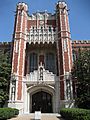
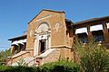
Bizzell Memorial Library
The Bizzell Memorial Library is a very important building. It's not just on the National Register; it's also a National Historic Landmark. This means it's one of the most significant historic places in the entire country! Located at 401 W. Brooks St. in Norman, it was added to the list in 2001. It's a beautiful and grand building that has served students for many years.
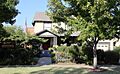
Beta Theta Pi Fraternity House
The Beta Theta Pi Fraternity House is another historic building on the University of Oklahoma campus. You can find it at 800 S. Chautauqua Ave. in Norman. This house was recognized for its history in 1982.
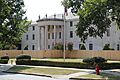
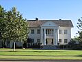
President's House
The President's House at the University of Oklahoma, also known as the Boyd House, is where the university's president lives. This historic home at 401 W. Boyd St. in Norman was added to the Register in 1976.
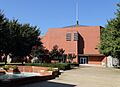
Oklahoma Center for Continuing Education Historic District
This district includes several buildings important for ongoing learning and events at the university. It's bounded by Asp Ave., Kellogg Dr., Maple, and 4th Sts. in Norman. It became a historic district in 2011.
University of Oklahoma Armory
The University of Oklahoma Armory is located at 103 W. Brooks St. in Norman. This building, important for military training and activities at the university, was listed in 2015.
Norman's Downtown and Neighborhood Gems
Beyond the university, many other buildings and areas in Norman have historical significance.
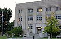
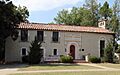
Cleveland County Courthouse
The Cleveland County Courthouse is a key building for the county's government. Located at 200 S. Peters Ave. in Norman, it was added to the National Register in 2000. It's where many important county decisions are made.
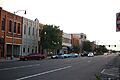
Downtown Norman Historic District
The Downtown Norman Historic District covers a large part of the city's main business area. It includes buildings along Main Street and nearby areas. This district was first listed in 1978 and expanded in 2012. It shows how Norman's downtown has grown over time.
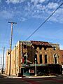
Sooner Theater Building
The Sooner Theater Building at 101 E. Main St. in Norman is a classic movie theater and performance venue. It was listed in 1978 and is still a popular spot for entertainment today.
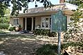
Norman Public Library
The Norman Public Library building at 329 S. Peters Ave. was an important community hub. It was recognized for its history in 2000.
United States Post Office-Norman
The United States Post Office-Norman building at 207 E. Gray St. served the community for many years. It was added to the Register in 2000.
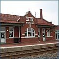
Santa Fe Depot
The Santa Fe Depot is an old train station located at the junction of Abner Norman Dr. and Comanche St. in Norman. This depot, listed in 1991, was once a busy place for travelers and goods arriving by train.
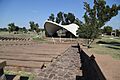
Norman City Park New Deal Resources
This historic area within Norman City Park includes structures built during the "New Deal" era in the 1930s. These projects helped people find work during tough economic times. It's located at the junction of Daws St. and Webster Ave. and was listed in 2000.
Historic Homes in Norman
Several individual homes in Norman are also on the National Register, each with its own unique story and architectural style.
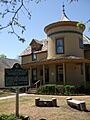
- Casa Blanca: This home at 103 W. Boyd was listed in 1990.
- Patricio Gimeno House: Located at 800 Elm St., this house was recognized in 1991.
- Oscar B. Jacobson House: Found at 609 S. Chatauqua Ave., it was listed in 1986.
- H.E. Ledbetter House: This home at 701 W. Brooks was added to the Register in 2001.
- Logan Apartments: These apartments at 720 W. Boyd St. were listed in 2014.
- Moore-Lindsay House: Located at 508 N. Peters, this house was listed in 1985.
DeBarr Historic District
The DeBarr Historic District is a neighborhood area roughly bounded by Boyd St., DeBarr Ave., Duffy St., and old railroad tracks. This district was recognized in 1991 for its collection of historic homes and buildings.
Historic Places Outside Norman
Cleveland County has historic sites beyond Norman, too!
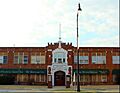
Moore Public School Building
The Moore Public School Building in Moore is an important part of that city's history. Located at NW. 1st and Broadway, it was listed in 1984.
Mardock Mission
The Mardock Mission is located southeast of Stella off State Highway 9. This site was added to the Register in 1983.
US Highway 77 Bridge at Canadian River
This bridge, also known as the James C. Nance Memorial Bridge, carries U.S. Route 77 over the Canadian River. It connects Cleveland County with McClain County. It was listed in 2003.
Union School District 19 1/2
This historic school building is located at the SW. corner of 149th St. & S. Luther Rd. near Newalla. It was listed in 2014, showing the importance of old schoolhouses.
Former Listings
Sometimes, a place that was once on the National Register of Historic Places is removed from the list. This can happen for different reasons, like if the building is changed too much or is no longer standing.
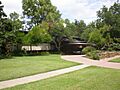
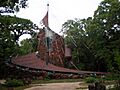
Eugene Bavinger House
The Eugene Bavinger House in Norman was a unique and famous home. It was listed in 2001 but was later removed from the Register in 2017.
Images for kids
-
The Beta Theta Pi Fraternity House
-
Bizzell Memorial Library
-
Casa Blanca in Norman
-
The Cleveland County Courthouse
-
A home in the DeBarr Historic District
-
East Main Street in the Downtown Norman Historic District
-
The Patricio Gimeno House
-
The Oscar B. Jacobson House
-
The H.E. Ledbetter House
-

The Logan Apartments
-
The Moore Public School Building
-
The Moore-Lindsay House
-
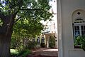
Amphitheater in Norman City Park
-
The old Norman Public Library building
-
Thurman J. White Forum in the Oklahoma Center for Continuing Education Historic District
-
The President's House at the University of Oklahoma
-
The Santa Fe Depot in Norman
-
The Sooner Theater Building
-

The James C. Nance Memorial Bridge
-

The old Norman Post Office
-
The exterior of the Eugene Bavinger House


