
National Register of Historic Places listings in Jackson County, Oklahoma facts for kids

Welcome to Jackson County, Oklahoma! Did you know that some buildings, places, and objects here are super special? They are so important that they are listed on the National Register of Historic Places. This is like a special list kept by the United States government. It helps protect places that tell us about America's past.
In Jackson County, there are 10 amazing places on this list. They include old homes, a ranch, a cemetery, and even a train station! Each one has a unique story to tell about the history of this area. Let's explore some of these cool historic spots!
Discovering Jackson County's Historic Treasures
The National Register of Historic Places is a list of buildings, districts, objects, sites, and structures that are important in American history. When a place is added to this list, it means it's recognized for its special history, architecture, or culture. This helps people understand and protect these valuable parts of our past.
Historic Homes and Buildings
Many of the places on the list in Jackson County are old homes or important buildings. They show us how people lived and worked many years ago.
W. C. Baker House

The W. C. Baker House is located at 301 East Commerce Street in Altus. It was added to the National Register in 2005. This house is a great example of the architecture from its time. It helps us imagine what life was like in Altus in the early 1900s.
Elmer and Lela Garnett House

Another interesting home is the Elmer and Lela Garnett House. You can find it at 801 East Commerce Street in Altus. This house joined the historic list in 2011. It's special because it shows us more about the homes built in this area long ago.
Jackson County Courthouse and Jail

The Jackson County Courthouse and Jail are very important buildings in Altus. They are located on Main Street and Broadway. These buildings were added to the National Register in 1984. Courthouses are often central to a county's history, as they are where important decisions are made. The jail also tells a story about law and order in the past.
Olustee Public Library and Park

In Olustee, the Public Library and Park are also on the historic list. They are on the southern side of 4th Street between C and D Streets. This spot became historic in 2006. Libraries are important places for learning and community gatherings, and this one has a long history of serving the people of Olustee.
Wichita Falls & Northwestern Railroad Passenger Depot

The Wichita Falls & Northwestern Railroad Passenger Depot is at 523 South Main Street in Altus. This old train station was added to the list in 2008. Train depots were once very busy places, connecting towns and bringing people and goods. This depot reminds us of the important role railroads played in developing Oklahoma.
Historic Ranches and Sites
Jackson County also has historic ranches and other unique sites that tell stories about the area's past.
Cross S Ranch Headquarters
The Cross S Ranch Headquarters is located near Olustee. It's about 1.3 miles west and 0.4 miles north of the junction of County Roads N199 and E1750. This ranch was added to the National Register in 2006. Ranches are a big part of Oklahoma's history, showing how people worked the land and raised livestock.
Frazer Cemetery

The Frazer Cemetery is a historic burial ground near Altus. It's about 0.5 miles south of the junction of County Road 202 and US 62. This cemetery was added to the list in 2011. Cemeteries can be important historical sites because they hold the graves of early settlers and tell us about the community's past.
Fullerton Dam
The Fullerton Dam is an interesting historic site located about 7 miles northwest of Olustee. It was recognized as historic in 1976. Dams are important structures that help manage water resources, and this one likely played a key role in the area's development.
Perryman Ranch Headquarters
Another historic ranch is the Perryman Ranch Headquarters, located near East Duke. It's about 0.2 miles east of the junction of County Roads N193 and E159. This ranch joined the National Register in 2007. Like the Cross S Ranch, it represents the rich ranching history of Jackson County.
Images for kids
-
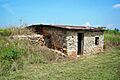
A half-dugout structure, possibly from the Perryman Ranch.

