Texola, Oklahoma facts for kids
Quick facts for kids
Texola, Oklahoma
|
|
|---|---|

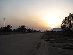
5th Street (Historic Route 66) in Texola
|
|
| Nickname(s):
Beerola
|
|

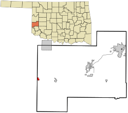
Location in Beckham County and the state of Oklahoma.
|
|
| Country | United States |
| State | Oklahoma |
| County | Beckham |
| Area | |
| • Total | 0.61 sq mi (1.59 km2) |
| • Land | 0.61 sq mi (1.59 km2) |
| • Water | 0.00 sq mi (0.00 km2) |
| Elevation | 2,152 ft (656 m) |
| Population
(2020)
|
|
| • Total | 43 |
| • Density | 70.26/sq mi (27.11/km2) |
| Time zone | UTC-6 (Central (CST)) |
| • Summer (DST) | UTC-5 (CDT) |
| ZIP code |
73668
|
| Area code(s) | 580 |
| FIPS code | 40-73150 |
| GNIS feature ID | 2413380 |
Texola is a small town located in Beckham County, Oklahoma, United States. In 2020, the town had a population of 43 people. This was a small increase from the 36 people counted in the 2010 census.
Contents
History of Texola
The story of Texola began in the early 1900s. Before it was called Texola, the area had other names like Texokla and Texoma. Because of its special location near the 100th Meridian, the town was surveyed many times. This meant some early residents actually lived in both Texas and Oklahoma without ever moving their homes!
Texola was first part of northern Greer County. Later, Beckham County was created after Oklahoma became a state in 1907. A post office opened in Texola on December 12, 1901. Reuben H. Grimes was the first postmaster.
In 1902, a railroad called the Choctaw, Oklahoma and Gulf Railroad was built through the town. This railroad later became part of the Chicago, Rock Island and Pacific Railway. A local newspaper, the Texola Herald, started in 1902 and was printed until the early 1920s.
By 1909, Texola had two cotton gins and a mill for corn. The town's economy was mostly based on farming. Many businesses opened to support the local farmers.
Growth and Decline
In 1910, 361 people lived in Texola. A small jail was built that same year. After a slight drop in population, Texola grew a lot in the 1920s. The town's population reached its highest point in 1930, with 581 people.
When Route 66 (also known as 5th Street) came through town, it helped the local economy. More cotton was grown, so two more cotton gins were needed. Texola also had a ten-acre park and an auditorium that could hold 300 people.
However, the population started to go down in the 1940s and kept falling. By 1980, only 106 people lived in Texola. In 1990, the population dropped even more to just 45 people. The number of residents remains low today, with 43 people in 2020.
Historic Places to See
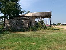
The Magnolia Service Station in Texola is a special building. It is listed on the National Register of Historic Places listings in Beckham County, Oklahoma. The station was built in 1930 by the Magnolia Petroleum Company right on Route 66.
Another interesting spot in Texola is the One Room Jail. This unique jail was built in the late 1800s from cinder blocks. It has only one room with a metal-barred door and window.
Geography of Texola
Texola covers about 0.6 square miles (1.59 square kilometers) of land. There is no water area within the town limits.
Texola is not directly on Oklahoma's main highway system. However, you can reach the town from I-40 at Exit 1. For many years, Route 66 passed through Texola, bringing many travelers. But in 1975, I-40 was finished to the north, and Route 66 became less used.
Population Information
| Historical population | |||
|---|---|---|---|
| Census | Pop. | %± | |
| 1910 | 361 | — | |
| 1920 | 298 | −17.5% | |
| 1930 | 581 | 95.0% | |
| 1940 | 337 | −42.0% | |
| 1950 | 265 | −21.4% | |
| 1960 | 202 | −23.8% | |
| 1970 | 144 | −28.7% | |
| 1980 | 106 | −26.4% | |
| 1990 | 45 | −57.5% | |
| 2000 | 47 | 4.4% | |
| 2010 | 36 | −23.4% | |
| 2020 | 43 | 19.4% | |
| U.S. Decennial Census | |||
In 2000, Texola had 47 people living in 21 households. Most of the people were White (65.96%), with smaller numbers of African American, Native American, and Asian residents. About 8.51% of the population identified as being of two or more races.
The average household had about 2.24 people. About 23.8% of households had children under 18. The median age in Texola was 46 years old. This means half the people were younger than 46, and half were older.
Education in Texola
Students in Texola attend schools in the Erick Public Schools district. This school district is based in the city of Erick. The district has two schools: an elementary school and a high school.
See also
 In Spanish: Texola (Oklahoma) para niños
 | Sharif Bey |
 | Hale Woodruff |
 | Richmond Barthé |
 | Purvis Young |


