Sayre, Oklahoma facts for kids
Quick facts for kids
Sayre, Oklahoma
|
|
|---|---|

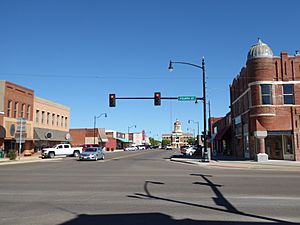
Buildings in Sayre, 2016
|
|
| Motto(s):
"Main Street On Historic Route (66)"
|
|

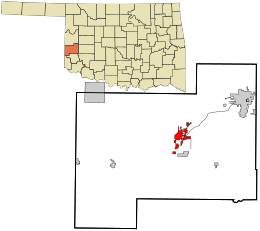
Location in Beckham County and the state of Oklahoma
|
|
| Country | United States |
| State | Oklahoma |
| County | Beckham |
| Government | |
| • Type | Aldermanic |
| Area | |
| • Total | 5.41 sq mi (14.00 km2) |
| • Land | 5.39 sq mi (13.95 km2) |
| • Water | 0.02 sq mi (0.05 km2) |
| Elevation | 1,893 ft (577 m) |
| Population
(2020)
|
|
| • Total | 4,809 |
| • Density | 892.87/sq mi (344.72/km2) |
| Time zone | UTC-6 (Central (CST)) |
| • Summer (DST) | UTC-5 (CDT) |
| ZIP code |
73662
|
| Area code(s) | 580 |
| FIPS code | 40-65700 |
| GNIS feature ID | 2411836 |
Sayre is a city in western Oklahoma, United States. It is the main town, or county seat, of Beckham County. Sayre is located right between Oklahoma City and Amarillo, Texas. You can find it along Interstate 40 and the famous old U.S. Route 66.
In 2020, about 4,809 people lived in Sayre. This was more than the 4,375 people counted in 2010. It was also the largest population Sayre has ever had!
Contents
History of Sayre
How Sayre Began: Railroads and New Towns
After the American Civil War, the U.S. government wanted to help the country grow. They encouraged building railroads across the western United States. These railroads helped move goods and people.
Around the early 1900s, new train tracks were built through Indian Territory, which is now Oklahoma. In July 1901, a new rail line was extended to Texola. Smart business people bought land near these new tracks and close to water sources.
The Choctaw Town Site and Improvement Company did this. When the Choctaw, Oklahoma and Gulf Railroad crossed the North Fork of the Red River, a new town quickly appeared. This town officially became a city on September 14, 1901.
Building a New Community
The Choctaw Townsite & Improvement Company started selling land to new settlers. These settlers were often called "Sooners" in Oklahoma. They came to start fresh lives. Businesses opened to sell things to the new townspeople. Within just one year, about 1,000 people lived in Sayre.
The town was named after Pennsylvanian Robert Heysham Sayre. He was an important investor in the railroad.
The Chicago, Rock Island and Pacific Railway Company, also known as the "Rock Island," leased this new rail line. They continued building tracks all the way to Tucumcari, New Mexico.
Sayre Becomes a County Seat
From 1901 to 1907, Sayre was part of Roger Mills County in Oklahoma Territory. When Oklahoma became a state, Beckham County was created. Sayre was chosen as the temporary county seat, which means it was the main town for the county government.
In 1908, people voted to make Sayre the permanent county seat. They chose Sayre over the town of Erick. The Beckham County Courthouse was finished in 1911. It is still used today and is listed on the National Register of Historic Places. This means it's a very important historical building!
Growth and Famous Connections
Between 1920 and 1930, Sayre's population grew a lot. This was because oil and natural gas were discovered nearby. In the 1930s, the famous U.S. Route 66 came through Sayre. This highway helped the town by bringing travelers who needed gas and food.
In 1940, a famous film director named John Ford used Sayre's Beckham County Courthouse in his movie The Grapes of Wrath. This movie was based on a very well-known book by John Steinbeck.
During the 1970s, Sayre also benefited from the oil and natural gas industry. The nearby Panhandle-Hugoton field is one of the largest gas fields in the world. It's also the biggest known source of helium.
Sayre's Location and Environment
Sayre is located on the North Fork of the Red River. It sits at an elevation of about 1,800 feet (550 m). This is about 128 miles (206 km) west of Oklahoma City. The area around Sayre has gentle, rolling hills made of red clay.
The city covers a total area of about 5.6 square miles (14.5 km2). Only a very small part of this, about 0.019 square miles (0.05 km2), is water.
Population of Sayre
| Historical population | |||
|---|---|---|---|
| Census | Pop. | %± | |
| 1910 | 1,881 | — | |
| 1920 | 1,703 | −9.5% | |
| 1930 | 3,157 | 85.4% | |
| 1940 | 3,037 | −3.8% | |
| 1950 | 3,362 | 10.7% | |
| 1960 | 2,913 | −13.4% | |
| 1970 | 2,712 | −6.9% | |
| 1980 | 3,177 | 17.1% | |
| 1990 | 2,881 | −9.3% | |
| 2000 | 4,114 | 42.8% | |
| 2010 | 4,375 | 6.3% | |
| 2020 | 4,809 | 9.9% | |
| U.S. Decennial Census | |||
Let's look at the numbers of people who have lived in Sayre over the years. This information comes from the census, which counts people every ten years.
In 2000, there were 4,114 people living in Sayre. There were 1,132 households, which are groups of people living together. About 26.7% of these households had children under 18. Many households were married couples living together.
The population included people from different backgrounds. About 75% were White, 18% were African American, and 2.5% were Native American. About 5% of the population was Hispanic or Latino.
The average age of people in Sayre in 2000 was 35 years old.
Sayre's Economy
Sayre's economy has always depended on farming and producing oil and gas. By the 1930s, Sayre had five oil companies and a plant that made gasoline. A company called United Carbon Company also built a carbon black plant there.
Around the year 2000, a large Flying J truck stop opened in Sayre. It was built on a 28-acre (11 ha) piece of land along Interstate 40. In 2001, this truck stop paid $150,000 in sales taxes each year and had 117 employees. The city government helped make this happen by buying the land and selling it to the company. This helped bring new jobs and money to Sayre.
The North Fork Correctional Facility, a privately owned prison, opened in 1998. In 2001, this prison had 270 employees. It helped boost Sayre's economy and community spirit.
Education in Sayre
Sayre offers several educational opportunities for students and adults.
Southwestern Oklahoma State University at Sayre
Southwestern Oklahoma State University at Sayre, or SWOSU@Sayre, is a junior college. It helps students in western Oklahoma get a college education. It started in 1938 as Sayre Junior College. Later, in 1987, it became part of SWOSU.
Western Technology Center
The Western Technology Center has a campus in Sayre. It helps both high school students and adults learn skills for specific jobs. Sayre Public Schools is part of this technology center district.
Sayre Public Schools
Sayre Public Schools is the school district for Sayre and Elk City. It includes:
- Sayre Elementary School
- Sayre Middle School
- Sayre High School
Historic Places in Sayre
Many places in and around Sayre are listed on the National Register of Historic Places. This means they are important historical sites. Some of these include:
- Beckham County Courthouse (NR 84002968)
- J. W. Danner House (NR 02000169)
- Sayre Champlin Service Station (NR 04000130)
- Sayre Rock Island Depot (also known as the Shortgrass Country Museum, NR 00000654)
- Sayre City Park (NR 04000127)
- Sayre Downtown Historic District (NR 02000972)
Notable People from Sayre
- Maxie Anderson: A hot air balloonist who was part of the first team to cross the Atlantic Ocean in a balloon.
- Leo Meyer: He served as the mayor of Sayre from 1905 to 1906. Later, he became the first assistant Secretary of State for Oklahoma.
See also
 In Spanish: Sayre (Oklahoma) para niños
 | Bessie Coleman |
 | Spann Watson |
 | Jill E. Brown |
 | Sherman W. White |

