
Kingfisher County, Oklahoma facts for kids
Quick facts for kids
Kingfisher County
|
|
|---|---|
.jpg)
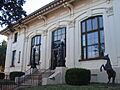
Post Office in Kingfisher (2014)
|
|

Location within the U.S. state of Oklahoma
|
|
 Oklahoma's location within the U.S. |
|
| Country | |
| State | |
| Founded | May 2, 1890 |
| Seat | Kingfisher |
| Largest city | Kingfisher |
| Area | |
| • Total | 906 sq mi (2,350 km2) |
| • Land | 898 sq mi (2,330 km2) |
| • Water | 7.9 sq mi (20 km2) 0.9%% |
| Population
(2020)
|
|
| • Total | 15,184 |
| • Density | 16.759/sq mi (6.471/km2) |
| Time zone | UTC−6 (Central) |
| • Summer (DST) | UTC−5 (CDT) |
| Congressional district | 3rd |
Kingfisher County is a county in Oklahoma, a state in the United States. In 2020, about 15,184 people lived here. The main town and county seat is Kingfisher. The county was created in 1890. Its name, Kingfisher, was chosen by the people living there.
This land was first given to the Creek Nation by the government. But it was taken back after the American Civil War.
Contents
History of Kingfisher County
Scientists have found signs that people lived in this area a very long time ago. These early groups, like the Paleo-Indians, used the land for hunting and gathering food. Later, tribes such as the Osage, Cheyenne, and Comanche traveled across these grasslands.
Before Kingfisher County was officially formed, the famous Chisholm Trail passed through it. This trail had many paths. It was used to move cattle. There were important stops along a road next to the trail. These stops included Dover Station and King Fisher Station.
How the Land Became Kingfisher County
The government first gave this land to the Creek Nation. This happened after they were forced to move from Georgia. After the American Civil War, the Creeks had to give the land back. This was because they had sided with the Confederacy. The land then became part of the "Unassigned Lands".
On April 22, 1889, these lands were opened for new settlers. This event was called the land run. Many towns, including Kingfisher, Oklahoma, quickly grew after this.
Naming Kingfisher County
When Oklahoma Territory was created in 1890, this area was called County 5. On August 5, 1890, people voted to name it "Kingfisher." They chose this over "Hennessey" and "Harrison."
No one is completely sure how the name "Kingfisher" came about. One idea is that it honored a local rancher named David King Fisher. Another idea is that "King" and "Fisher" were two different settlers. A third story says the name came from a rancher named John Fisher.
Geography of Kingfisher County
Kingfisher County covers about 906 square miles. Most of this is land, about 898 square miles. The rest, about 7.9 square miles, is water. The main river flowing through the county is the Cimarron River. It runs from the northwest to the east.
Main Roads in the County
 U.S. Highway 81
 State Highway 3
 State Highway 33
 State Highway 51
 State Highway 132
Neighboring Counties
- Garfield County (north)
- Logan County (east)
- Canadian County (south)
- Blaine County (west)
- Major County (northwest)
- Oklahoma County (southeast)
People of Kingfisher County
| Historical population | |||
|---|---|---|---|
| Census | Pop. | %± | |
| 1910 | 18,825 | — | |
| 1920 | 15,671 | −16.8% | |
| 1930 | 15,960 | 1.8% | |
| 1940 | 15,617 | −2.1% | |
| 1950 | 12,860 | −17.7% | |
| 1960 | 10,635 | −17.3% | |
| 1970 | 12,857 | 20.9% | |
| 1980 | 14,187 | 10.3% | |
| 1990 | 13,212 | −6.9% | |
| 2000 | 13,926 | 5.4% | |
| 2010 | 15,034 | 8.0% | |
| 2020 | 15,184 | 1.0% | |
| 2023 (est.) | 15,481 | 3.0% | |
| U.S. Decennial Census 1790-1960 1900-1990 1990-2000 2010 |
|||

In 2000, there were 13,926 people living in Kingfisher County. This number grew to 15,184 people by 2020. The county had 5,247 households. Many of these were married couples living together. About 35% of households had children under 18.
The average age of people in the county was 38 years old. About 27% of the population was under 18. And about 15% were 65 years or older.
Towns and Communities
Economy of Kingfisher County
Farming has been the most important part of the county's economy since 1899. Wheat and rye are the main crops grown here.
In the 1920s, finding oil and natural gas became very important. This was especially true around the towns of Hennessey, Cashion, and Dover. Roxana was a "boomtown" during this time. A boomtown is a town that grows very quickly because of a sudden economic opportunity. Roxana's population reached 1,000 people, but then it quickly shrank. Now, it is considered a ghost town.
Education in Kingfisher County
Kingfisher Academy was a school started in Kingfisher before Oklahoma became a state. It was open from 1890 to 1894. Later, in 1895, a group called the Association of Congregational Churches of Oklahoma Territory started Kingfisher College. It opened its doors on September 2, 1895.
Historic Places
Many places in Kingfisher County are listed on the National Register of Historic Places. This means they are important historical sites. Some of these include:
- Burrus Mills Elevator C, Kingfisher
- Dow Grain Company Elevator, Okarche
- Farmers and Merchants National Bank, Hennessey
- Farmers Co-op Elevator, Hennessey
- Kiel-Dover Farmers Elevator, Dover
- Kingfisher Armory, Kingfisher
- Kingfisher College, Kingfisher
- Kingfisher Post Office, Kingfisher
- Seay Mansion, Kingfisher
Images for kids
-
Post Office in Kingfisher (2014)
See also
 In Spanish: Condado de Kingfisher para niños
