Seiling, Oklahoma facts for kids
Quick facts for kids
Seiling, Oklahoma
|
|
|---|---|

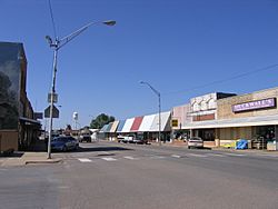
Downtown Seiling
|
|
| Nickname(s):
Crossroads of Northwest Oklahoma
|
|

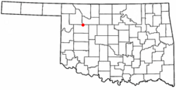
Location of Seiling, Oklahoma
|
|
| Country | United States |
| State | Oklahoma |
| County | Dewey |
| Area | |
| • Total | 1.19 sq mi (3.07 km2) |
| • Land | 1.19 sq mi (3.07 km2) |
| • Water | 0.00 sq mi (0.00 km2) |
| Elevation | 1,736 ft (529 m) |
| Population
(2020)
|
|
| • Total | 850 |
| • Density | 716.69/sq mi (276.65/km2) |
| Time zone | UTC-6 (Central (CST)) |
| • Summer (DST) | UTC-5 (CDT) |
| ZIP code |
73663
|
| Area code(s) | 580 |
| FIPS code | 40-66250 |
| GNIS feature ID | 2411861 |
Seiling is a city in Dewey County, Oklahoma, United States. In 2020, about 850 people lived there. The city was named in 1899 after Louis Seiling. He was a local store owner who got land during the Cheyenne-Arapaho land run in 1892.
Before it was called Seiling, a company tried to start a town named Hobson. But in January 1899, the name was changed to Seiling. The city officially became a town in 1909. Today, Seiling is the biggest city in Dewey County. The girls' basketball team from Seiling is very successful. They won the Oklahoma State Championship four times in a row from 2016 to 2019!
Contents
History of Seiling
Seiling grew into an important farming area for the region. It became the largest town in Dewey County. This happened even though the closest train station was far away in Canton, about 25 miles (40 km) from Seiling. Also, there were no bridges over the Canadian rivers until 1906. A horse racing track was built in Seiling in 1903.
Where is Seiling Located?
Seiling is located just south of the North Canadian River. It is also about 7 miles (11 km) north of the Canadian River. The city is about 10 miles (16 km) from Taloga, which is the county seat.
The United States Census Bureau says that Seiling covers about 0.8 square miles (2.1 square kilometers) of land. There is no water area within the city limits.
People of Seiling
| Historical population | |||
|---|---|---|---|
| Census | Pop. | %± | |
| 1910 | 352 | — | |
| 1920 | 323 | −8.2% | |
| 1930 | 568 | 75.9% | |
| 1940 | 629 | 10.7% | |
| 1950 | 700 | 11.3% | |
| 1960 | 910 | 30.0% | |
| 1970 | 1,033 | 13.5% | |
| 1980 | 1,103 | 6.8% | |
| 1990 | 1,031 | −6.5% | |
| 2000 | 875 | −15.1% | |
| 2010 | 860 | −1.7% | |
| 2020 | 850 | −1.2% | |
| U.S. Decennial Census | |||
In 2010, there were 860 people living in Seiling. There were 325 households, and 216 of them were families. The city had about 1,000 people per square mile (386 per square kilometer).
Most residents, about 95.1%, identified as white. About 12.7% were Native American. Some people, 4.9%, were of mixed heritage. A smaller number were Asian (1.6%) or African American (0.1%). About 3.7% of the population identified as Hispanic or Latino.
About 29.5% of households had children under 18 living with them. Nearly half, 48.9%, were married couples. The average household had 2.58 people, and the average family had 3.24 people. The median age in the city was 37.9 years old.
The median income for a household in Seiling was $45,650. For a family, it was $58,466. The average income per person in the city was $24,410. About 9.7% of people lived below the poverty line.
Economy and Jobs
Since the land was opened for settlement, farming has been the main part of Seiling's economy. At first, the main crops were broomcorn and cotton. Seiling quickly got a cotton gin and a feed mill to process these crops.
Before World War I, wheat and rye also became important crops. In 1918, the Seiling Milling Company opened a flour mill. They sold "White Rose Special" flour until the mill closed in 1952.
Getting Around Seiling
Seiling is a hub for several major roads. US-60, US-270, US-281, SH-3, and SH-51 all pass through the town. Some of these roads even run together for a bit. US-183 is also very close, just to the west. Because so many roads meet here, the town calls itself the "Crossroads of Northwest Oklahoma."
Seiling also has its own airport, called Seiling Airport (FAA Identifier: 1S4). It is located right next to the city on the northwest side.
Fun Things to Do
Seiling offers several places for recreation and fun:
- Seiling City Park: This park is located within the town, right on Seiling Creek. It's a great place to relax outdoors.
- Seiling Golf Course: If you like golf, there's a 9-hole course that was built in 1980.
- Seiling Swimming Pool: The city swimming pool is open to everyone. You can also rent it for special events.
- Canton Lake: Just east of Seiling, you'll find Canton Lake. It's a popular spot for water activities and fishing.
- Little Sahara State Park: About a half-hour drive north of Seiling is Little Sahara State Park. This park is famous for its large sand dunes, where people enjoy riding ATVs and dune buggies.
There are also two historic places in Seiling listed on the National Register of Historic Places listings in Dewey County, Oklahoma:
- The McAllister House at 311 N. Locust Ave.
- The Seiling Milling Company at 4th and Orange St.
Famous People from Seiling
Several notable people have connections to Seiling:
- Gary England: A well-known meteorologist for KWTV-News 9.
- Jordy Mercer: A professional Major League baseball player.
- Carrie Nation: A famous advocate for Prohibition, which was a time when alcohol was banned.
- Tom L. Ward: A successful businessman in the oil and gas industry.
See also
In Spanish: Seiling (Oklahoma) para niños
 | Bayard Rustin |
 | Jeannette Carter |
 | Jeremiah A. Brown |

