Camargo, Oklahoma facts for kids
Quick facts for kids
Camargo, Oklahoma
|
|
|---|---|

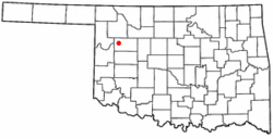
Location of Camargo, Oklahoma
|
|
| Country | United States |
| State | Oklahoma |
| County | Dewey |
| Area | |
| • Total | 0.25 sq mi (0.64 km2) |
| • Land | 0.25 sq mi (0.64 km2) |
| • Water | 0.00 sq mi (0.00 km2) |
| Elevation | 1,942 ft (592 m) |
| Population
(2020)
|
|
| • Total | 193 |
| • Density | 775.10/sq mi (299.84/km2) |
| Time zone | UTC-6 (Central (CST)) |
| • Summer (DST) | UTC-5 (CDT) |
| ZIP code |
73835
|
| Area code(s) | 580 |
| FIPS code | 40-11150 |
| GNIS feature ID | 2413152 |
Camargo is a small town located in Dewey County, Oklahoma, in the United States. In 2020, about 193 people lived there. This was a bit more than the 178 people counted in 2010, and much more than the 115 people in 2000.
Contents
History of Camargo
The land where Camargo is now was once part of the Cheyenne and Arapaho Reservation. This was a special area set aside for Native American tribes. On April 19, 1892, the land was opened for other people to settle there.
A post office was set up in Camargo on September 16, 1892. People have two ideas about how the town got its name. One story says it was named after a town in Illinois. Another story suggests that "Camargo" meant "little dog" in the Cheyenne language.
Early Economy and Railroads
In its early days, Camargo's economy was mostly about farming and ranching. People grew crops and raised animals to make a living.
A railroad line was built through Camargo in 1912. This line was part of the Wichita Falls and Northwestern Railway. Later, it became known as the Missouri, Kansas and Texas Railway, or "Katy." This railroad helped connect Camargo to other towns like Leedey and Forgan.
Mining and Famous Residents
A mineral called Bentonite was mined in the area around Camargo. This mineral was then shipped out using the railroad. The railroad stopped running in 1972 or 1973.
A famous person named Sylvan Ambrose Hart was born in Camargo. He was known as one of the last "mountain men." He was the oldest of six children.
Geography of Camargo
Camargo is located in a convenient spot in Oklahoma. It is about halfway between the towns of Leedey and Vici. You can find it along State Highway 34.
The United States Census Bureau is a government agency that collects information about places. They say that Camargo covers about 0.2 square miles (0.64 square kilometers). All of this area is land, with no large bodies of water.
Population and People
| Historical population | |||
|---|---|---|---|
| Census | Pop. | %± | |
| 1930 | 291 | — | |
| 1940 | 289 | −0.7% | |
| 1950 | 315 | 9.0% | |
| 1960 | 254 | −19.4% | |
| 1970 | 236 | −7.1% | |
| 1980 | 264 | 11.9% | |
| 1990 | 185 | −29.9% | |
| 2000 | 115 | −37.8% | |
| 2010 | 178 | 54.8% | |
| 2020 | 193 | 8.4% | |
| U.S. Decennial Census | |||
According to the census from 2000, there were 115 people living in Camargo. These people lived in 57 different homes, and 33 of those were families.
Most of the people in Camargo were White (99.13%). A small number (0.87%) were from two or more racial backgrounds. About 1.74% of the population identified as Hispanic or Latino.
Households and Age Groups
Out of the 57 homes, about 22.8% had children under 18 living there. Many homes (42.1%) were married couples living together. Some homes (10.5%) had a female head of household with no husband present. About 42.1% of all homes were made up of single individuals. Of these, 24.6% had someone living alone who was 65 years old or older.
The average number of people in a home was 2.02, and the average family size was 2.76.
The population was spread out across different age groups. About 20.9% of the people were under 18 years old. About 11.3% were between 18 and 24. Another 17.4% were between 25 and 44. The largest group, 27.8%, was between 45 and 64 years old. Finally, 22.6% of the people were 65 years old or older. The average age in Camargo was 45 years.
For every 100 females, there were about 91.7 males. If you looked at just adults 18 and over, there were about 78.4 males for every 100 females.
See also
 In Spanish: Camargo (Oklahoma) para niños
 | Jackie Robinson |
 | Jack Johnson |
 | Althea Gibson |
 | Arthur Ashe |
 | Muhammad Ali |

